Börtlingen
| coat of arms | Germany map | |
|---|---|---|

|
Coordinates: 48 ° 45 ' N , 9 ° 38' E |
|
| Basic data | ||
| State : | Baden-Württemberg | |
| Administrative region : | Stuttgart | |
| County : | Goeppingen | |
| Height : | 450 m above sea level NHN | |
| Area : | 8.26 km 2 | |
| Residents: | 1688 (December 31, 2018) | |
| Population density : | 204 inhabitants per km 2 | |
| Postal code : | 73104 | |
| Area code : | 07161 | |
| License plate : | GP | |
| Community key : | 08 1 17 011 | |
| Address of the municipal administration: |
Hauptstrasse 54 73104 Börtlingen |
|
| Website : | ||
| Mayor : | Franz Wenka | |
| Location of the municipality of Börtlingen in the district of Göppingen | ||
Börtlingen is a municipality in the district of Göppingen , Baden-Württemberg ( Germany ). It belongs to the Stuttgart region (until 1992 the Middle Neckar region ) and the peripheral zone of the European metropolitan region of Stuttgart .
geography
Geographical location
Börtlingen is located in the Schurwald at an altitude of 334 to 498 meters, as the crow flies about 10 km north of the district town of Göppingen on a ridge between the valley of the Marbach in the east and an upper course of the Herrenbach in the west. In the east, the municipality extends beyond the forest valley basin of the Marbach, in the north it ends near the top left edge of the slope of the Remstal .
Börtlingen belongs to the outskirts of the Stuttgart metropolitan region .
geology
Börtlingen is essentially located on a Black Jurassic plateau in the eastern Schurwald. Tuber marl (calcareous clays) stand between the Stubensandstein underneath and the Schwarzjuraplatte .
Community structure
Börtlingen includes the village of Börtlingen, the hamlets of Breech (north of Börtlingen) and Zell (east towards Birenbach ), the Ödweiler and Schweizerhof farms and the Schneiderhof house as well as the abandoned village of Oedweiler.
Division of space

According to data from the State Statistical Office , as of 2014.
history
Until the 19th century
Börtlingen was first mentioned in a document in 1202 . For a long time it was under the control of the Adelberg Monastery . When this was dissolved in the course of the Reformation in 1535, Börtlingen came under the rule of the Protestant monastery office Adelberg . Börtlingen itself was the seat of a staff in this monastery office. With the dissolution of the monastery offices in 1807, the place came to the Oberamt Göppingen , the forerunner of today's district .
Population development
Source: Baden-Württemberg State Statistical Office for data from 1970
| date | Residents |
|---|---|
| 1837 | 669 |
| 1907 | 660 |
| May 17, 1939 | 651 |
| September 13, 1950 | 935 |
| May 27, 1970 | 1311 |
| December 31, 1983 | 1571 |
| May 25, 1987 | 1657 |
| December 31, 1991 | 1749 |
| December 31, 1995 | 1766 |
| December 31, 2000 | 1767 |
| December 31, 2005 | 1798 |
| December 31, 2010 | 1754 |
| December 31, 2015 | 1699 |
politics
Administrative association
Börtlingen belongs with Birenbach , Adelberg and Rechberghausen to the community administration association "Eastern Schurwald" , which has its seat in Rechberghausen.
Municipal council
The local council in Börtlingen has ten members. The local elections on May 26, 2019 led to the following final result. The municipal council consists of the elected voluntary councilors and the mayor as chairman. The mayor is entitled to vote in the municipal council.
| Parties and constituencies |
% 2019 |
Seats 2019 |
% 2014 |
Seats 2014 |
||
| FWV | Börtlingen Free Electoral Association | 55.10 | 6th | 65.46 | 7th | |
| ALLES | Independent voter association Börtlingen | 44.90 | 4th | 34.54 | 3 | |
| total | 100.0 | 10 | 100.0 | 10 | ||
| voter turnout | 75.00% | 61.26% | ||||
coat of arms
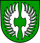
The blazon of the municipal coat of arms of Börtlingen reads: In green an open silver flight .
It was established in 1947 and goes back to the research of the former local pastor Hermann, according to which the original local nobility of the Lords of Bertnang should have carried this coat of arms. The coat of arms was awarded by the Ministry of the Interior on January 27, 1948, the white and green municipal flag on June 30, 1959.
Economy and Infrastructure
traffic
The easiest way to get to Börtlingen is by car via the B 297 and the K 1408 district road (junction between Rechberghausen and Birenbach ) from Lorch and Göppingen. Breech also has a connection to Rattenharz and the Remstal through the K 1408 . There are local connecting roads to Zachersmühle and Oberwälden as well as via the Kaisersträßle to Adelberg and Oberberken .
There is also a bus connection to and from Göppingen. Final stop at Göppingen train station .
Börtlingen was previously connected to the rail network by the now closed Hohenstaufenbahn ( Schwäbisch Gmünd - Göppingen ). However, the Adelberg-Börtlingen train station is approx. 3.5 km from the town center and is now privately owned.
education
With the Paul Roth School, Börtlingen has its own elementary school , and there is also a Protestant kindergarten . Secondary schools can be reached by bus in Rechberghausen and Göppingen.
Buildings
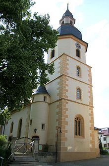
Located in the upper part of Börtlingen is the Johanneskirche , which was first mentioned in a document in 1202. The original late Gothic building of today's church was built around 1500 and was later probably modified in Baroque style in the 18th century . The parish mentioned in 1271 was incorporated into the Adelberg Monastery. From 1595 Börtlingen was a branch of Oberwälden. In 1844 Börtlingen became its own parish again. Today's Protestant parish of Börtlingen -Birenbach in the church district of Göppingen includes the communities of Börtlingen and Birenbach . The core of the Börtlinger church is late Gothic (around 1500), but has been changed several times. The tower was built in 1819. A Johannis bowl from the 14th century and a Vespers picture from 1500 have been preserved in the choir . As part of the major church renovation in 1956, the Stuttgart glass painter Adolf Valentin Saile created the choir window with motifs around John the Baptist and John the Evangelist.
Between the district of Breech and Rattenharz , on the district road K 1408, ( 48 ° 46 ′ 10 ″ N , 9 ° 38 ′ 29 ″ E ) is the Reinhold Maier Tower , which is colloquially known as the lighthouse long Franz . The observation tower, a former pendulum water tower , is around 25 m high and can also be seen from Börtlingen. It was built in 1914 and was used as a water tower until 2008, after which it was retained as a tower on the initiative of the mayor and some citizens and was not torn down. After a public survey and positive feedback, the tower was converted into a lookout tower in 2009.
Personalities
Honorary citizen
- Georg Ganzenberg (* July 14, 1914, † December 22, 2006) was a long-time village schoolmaster in Börtlingen and a founding member and honorary member of several Börtlinger associations.
Sons and daughters of the church
- Fritz Schwegler (1935–2014), artist
Web links
Individual evidence
- ↑ State Statistical Office Baden-Württemberg - Population by nationality and gender on December 31, 2018 (CSV file) ( help on this ).
- ↑ Kultur-Almanach Landkreis Göppingen , ISBN 978-3-00-019196-1 .
- ^ The state of Baden-Württemberg. Official description by district and municipality. Volume III: Stuttgart District, Middle Neckar Regional Association. Kohlhammer, Stuttgart 1978, ISBN 3-17-004758-2 , p. 340.
- ↑ State Statistical Office, area since 1988 according to actual use for Börtlingen.
- ↑ Brochure Börtlinger Weg
- ↑ Website of the Evangelical Church Community Börtlingen-Birenbach
- ↑ Marlies Barteit-Klopp: The John Church in Börtlingen. Flashlights into the past ; in: Hohenstaufen / Helfenstein. Historical yearbook for the Göppingen district 13; Hg. Geschichts- und Altertumsverein Göppingen eV; Art and History Association Geislingen eV, Walter Ziegler, Göppingen 2005
- ^ M. Brandstätter: The Johannes Church in Börtlingen ; Börtlingen 1986
- ↑ leaflet: Annette Imkampe: A church tour in the footsteps of Jesus ; Börtlingen o. J. (around 2000)
- ↑ Börtlingen local newspaper
- ↑ SWP Schurwald January 16, 2010 ( Memento of the original from September 11, 2012 in the web archive archive.today ) Info: The archive link was inserted automatically and has not yet been checked. Please check the original and archive link according to the instructions and then remove this notice.


