
Bad Ditzenbach
| coat of arms | Germany map | |
|---|---|---|

|
Coordinates: 48 ° 35 ' N , 9 ° 42' E |
|
| Basic data | ||
| State : | Baden-Württemberg | |
| Administrative region : | Stuttgart | |
| County : | Goeppingen | |
| Height : | 509 m above sea level NHN | |
| Area : | 25.45 km 2 | |
| Residents: | 3741 (Dec. 31, 2018) | |
| Population density : | 147 inhabitants per km 2 | |
| Postal code : | 73342 | |
| Primaries : | 07334, 07335 | |
| License plate : | GP | |
| Community key : | 08 1 17 006 | |
| LOCODE : | DE BDZ | |
| Address of the municipal administration: |
Hauptstrasse 44 73342 Bad Ditzenbach |
|
| Website : | ||
| Mayor : | Herbert Juhn (independent) | |
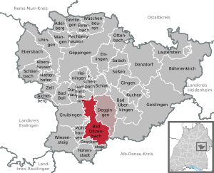
| Location of the municipality of Bad Ditzenbach in the district of Göppingen | ||
  |
||

Bad Ditzenbach is a municipality in Baden-Württemberg and belongs to the administrative district of Stuttgart . The state-recognized spa is located in the district of Göppingen .
geography
Geographical location
Bad Ditzenbach is located in the Upper Filstal in the north of the Swabian Alb between 498 and 781 meters above sea level . In Bad Ditzenbach the Ditz flows into the Fils .
Neighboring communities
The neighboring communities are (clockwise from the north) Heiningen , Schlat , Deggingen (all districts of Göppingen), Nellingen , Merklingen (both Alb-Donau district ), Drackenstein , Mühlhausen im Täle , Gruibingen and Gammelshausen (all districts of Göppingen).
Community structure

The three districts of Auendorf , Bad Ditzenbach and Gosbach belong to Bad Ditzenbach . The boundaries of the districts are identical to the former communities of the same name. The districts are officially named by prefixing the name of the municipality and followed by the name of the districts connected by a hyphen. The Auendorf district includes the village of Auendorf and the Hardtmühle. The Bad Ditzenbach district includes the village of Bad Ditzenbach and the Schonterhöhe homestead as well as the abandoned village of Hiltenburg. The Gosbach district includes the village of Gosbach, a large part of the new “Klingenbrunnen” building area and the Großmannshof homestead and the abandoned Leimberg Castle .
Division of space

According to data from the State Statistical Office , as of 2014.
history
In 861 the place Tizzenbach was first mentioned in a document from the Wiesensteig monastery .
In the Middle Ages , the Counts of Helfenstein ruled Bad Ditzenbach and the surrounding communities. The Hiltenburg castle ruins on the Schlossberg above Bad Ditzenbach still bear witness to this today .
The carbonated mineral springs were first mentioned in 1560 . This resulted in the establishment of the Ditzenbach mineral bath. In 1929 the title of a state-recognized spa was awarded.
At the time of Eduard Mörike , the then owner of the springs, Thomas Fritton, sold around 200,000 bottles per year. In a letter to his friend Karl Wolf in 1863, Mörike praised: “The benefits for my health that have been gained here have become apparent especially since the regular use of Dizenbacher water….” And confidently reported “the last remnant of the slimy being hopefully take away the Dizenbacher water. "
Incorporations
- September 1, 1973: incorporation of Auendorf (the former goose-less) into Bad Ditzenbach
- January 1, 1975: Merger of Bad Ditzenbach and Gosbach to form the new municipality of Bad Ditzenbach
Population development
Source: Baden-Württemberg State Statistical Office for data from 1961

| date | Residents |
|---|---|
| 1871 | 1636 |
| 1900 | 1560 |
| 1933 | 1732 |
| 1939 | 1785 |
| 1950 | 2336 |
| December 31, 1961 | 2794 |
| December 31, 1970 | 3081 |
| December 31, 1980 | 2976 |
| December 31, 1990 | 3263 |
| December 31, 1995 | 3555 |
| December 31, 2000 | 3666 |
| December 31, 2005 | 3737 |
| December 31, 2010 | 3674 |
| December 31, 2015 | 3652 |
| December 31, 2017 | 3725 |

Districts
Gosbach


In 1143 the Gosbach, crossed by the Gos brook , was first mentioned in a document. The coat of arms of the formerly independent community of Gosbach shows the Kreuzkapelle on the Leimberg.
Auendorf


Auendorf used to be called Ganslosen, which was first mentioned in 1137. The name was changed in 1849, as Ganslosen was one of the so-called fool's places (the most famous of which is Schilda, the home of the Schildbürger ), whose simple-minded inhabitants were ridiculed. Auendorf today has around 570 inhabitants. Auendorf is famous not only because of its earlier name and reputation, but also because of its rosehip pulp, which is still produced here in the traditional raw process.
Auendorf is the only district in the Bad Ditzenbach community with a predominantly Protestant population. While the upper Filstal was part of Württemberg only since 1806, Auendorf (Ganslosen) has belonged to Württemberg since 1418 and became Protestant with it in 1534. The Evangelical Church Community of Auendorf is still the only public body in Auendorf.
The Auendorfer coat of arms shows a green rose hip branch with two red fruits in gold. The local colors are red and gold.
politics
Municipal council
In Bad Ditzenbach, the municipal council is elected using the spurious selection of a part of town. The number of local councils can change due to overhang mandates . The local election on May 29, 2019 led to the following final result. The turnout was 62.0% (2014: 57.0%). The municipal council consists of the elected voluntary councilors and the mayor as chairman. The mayor is entitled to vote in the municipal council.
| Political party | be right | Seats | 2014 result |
| Citizen List | 82.71% | 11 | 0.0%, 0 seats |
| Green list | 17.29% | 2 | 0.0%, 0 seats |
| CDU | 0.0% | 0 | 49.6%, 6 seats |
| Free community of voters | 0.0% | 0 | 50.4%, 7 seats |
coat of arms
The blazon of the municipal coat of arms of Bad Ditzenbach reads: In gold, a green three mountain raised to close to the upper edge topped with a golden bowl fountain with rising and divided silver water jet .
The coat of arms thus symbolically shows the community's spa and the surrounding Alb landscape. A scarf fountain was used in an early coat of arms of Bad Ditzenbach. The current form was only introduced after the incorporation of Auendorf and Gosbach. The local colors are green and yellow. The coat of arms and flag was awarded on August 17, 1977 by the Göppingen District Office.
The old coat of arms showed a red bowl fountain with a rising and divided blue water jet above a shield base in silver, roughened diagonally to the right with cross-division .
The base of the shield with the Bavarian diamonds should remind that the place belonged to Bavaria until 1806. Silver and red were the colors of the Counts of Helfenstein.
The flag was blue and white.
The coat of arms and flag were awarded by the Ministry of the Interior on October 28, 1959.
 Bad Ditzenbach |
 Bad Ditzenbach old coat of arms |
|---|
Culture and sights


Bad Ditzenbach is located on the Swabian Albstraße , which leads past many sights. The Tiersteinfels above Gosbach forms the edge between the Alb plateau and the eastern slope of the Gos valley . This natural monument of the White Jura is a rock group with platforms, vertical crevices and vertical walls. Like the Oberbergfels, it grants a good view of the Upper Filstal.
building
- The Hiltenburg castle ruins
- Old village church of St. Laurentius (15th century)
- The Josef Chapel in Gosbach
- The Catholic parish church of St. Magnus in Gosbach
- The Protestant St. Stephen's Church in Auendorf with the oldest still played organ in the Göppingen district
- The Kreuzkapelle on the Leimberg in Gosbach
sport and freetime
- The Vinzenz Therme thermal mineral movement bath
Economy and Infrastructure
traffic
Bad Ditzenbach is on federal highway 466 . This leads via the Mühlhausen junction to the A8 Stuttgart - Munich motorway to the west .
The community belongs to the traffic community Stauferkreis . The bus line 56 connects the place with the nearest train station in Geislingen (Steige) . There is a connection to the large district town of Göppingen with lines 31 and 32. In addition to these, line 35 also offers a connection to Deggingen , the headquarters of the school center ( special needs school , secondary school and secondary school ).
Bad Ditzenbach was connected to the rail network from 1903 to 1968 by the valley railway from Geislingen to Wiesensteig ( Täleskäther ).
education
In Bad Ditzenbach there are two primary schools, the Hiltenburg School and the Ulrich Schiegg School in the Gosbach district . There is a kindergarten in each of the three districts .
literature
- Municipality of Bad Ditzenbach: Bad Ditzenbach: Spa on the Swabian Alb Horb am Neckar 1996.
- Karl Kirschmer: Chronicle of Auendorf-Ganslosen. Bad Ditzenbach-Auendorf 1984.
- u. a. Hyacinth Rink: Ditzenbach mineral bath and its healing springs. Ditzenbach 1931.
- Bad Ditzenbach community, Klaus Limmer: Gosbach in words and pictures: a home book with contributions to the past and present. Horb am Neckar 1994.
- Municipality of Bad Ditzenbach: From Ganslosen to Auendorf: a local chronicle; on the occasion of the 150th anniversary of the name change from Ganslosen in Auendorf in 1849. Horb am Neckar 1999.
Web links
Individual evidence
- ↑ State Statistical Office Baden-Württemberg - Population by nationality and gender on December 31, 2018 (CSV file) ( help on this ).
- ↑ Main statute of the municipality of Bad Ditzenbach from September 16, 1993, last changed on February 1, 2001 ( Memento from April 2, 2015 in the Internet Archive ) (PDF; 114 kB)
- ^ The state of Baden-Württemberg. Official description by district and municipality. Volume III: Stuttgart District, Middle Neckar Regional Association. Kohlhammer, Stuttgart 1978, ISBN 3-17-004758-2 . Pp. 291-293
- ↑ State Statistical Office, area since 1988 according to actual use for Bad Ditzenbach.
- ^ Federal Statistical Office (ed.): Historical municipality directory for the Federal Republic of Germany. Name, border and key number changes in municipalities, counties and administrative districts from May 27, 1970 to December 31, 1982 . W. Kohlhammer, Stuttgart / Mainz 1983, ISBN 3-17-003263-1 , p. 461 .
- ^ Federal Statistical Office (ed.): Historical municipality directory for the Federal Republic of Germany. Name, border and key number changes in municipalities, counties and administrative districts from May 27, 1970 to December 31, 1982 . W. Kohlhammer, Stuttgart / Mainz 1983, ISBN 3-17-003263-1 , p. 462 .
- ↑ Eberhard Gönner and Heinz Baruda: "Wappenbuch des Landkreises Göppingen" , published by the Landkreis Göppingen and the Stuttgart Archive Directorate, Verlag W. Kohlhammer, Stuttgart 1966
- ^ State film collection Baden-Württemberg: Bad Ditzenbach train station

Adelberg | Aichelberg | Albershausen | Bad Boll | Bad Ditzenbach | Bad Ueberkingen | Birenbach | Böhmenkirch | Börtlingen | Deggingen | Donzdorf | Drackenstein | Dürnau | Ebersbach an der Fils | Eislingen / Fils | Eschenbach | Gammelshausen | Geislingen an der Steige | Went to the Fils | Göppingen | Gruibingen | Hattenhofen | Heiningen | Hohenstadt | Cake | Lauterstein | Mühlhausen im Täle | Ottenbach | Rechberghausen | Salach | Schlat | Schlierbach | Cuties | Uhingen | Cheeks | Waschenbeuren | Wiesensteig | Zell under Aichelberg