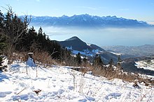
Le Folly
| Le Folly | ||
|---|---|---|
|
Vevey with Le Folly in the background |
||
| height | 1730 m above sea level M. | |
| location | Canton of Vaud , Switzerland | |
| Mountains | Freiburg Pre-Alps | |
| Dominance | 0.76 km → Le Molard | |
| Notch height | 110 m ↓ La Forcla | |
| Coordinates | 562 533 / 147 645 | |
|
|
||
| Normal way | Mountain hiking | |
Le Folly is 1730 m above sea level. M. high mountain of the Freiburg Pre-Alps on the border of the communities Blonay and Montreux in the Swiss canton of Vaud .
Surname
The name Folly is a common name in French- speaking Switzerland for, among other things, mountain slopes on which there were originally bushes or groups of hardwood trees.
location

The largely forested peak lies between three valleys: the Ruisseau de Saudanne in the north flows after a few kilometers into the Veveyse de Fégire, tributary of the Veveyse . In the southeast lies the valley of the Avessan torrent, which after a few kilometers flows into the Baye de Clarens , whose valley lies in the southwest of Le Folly. The watercourses flow into Lake Geneva at Vevey and Clarens .
Le Folly rises with about 110 meters saddle height above the pass La Forcla (about 1620 m above sea level. M. ) to the east, through which a mountain trail to Molard ( 1751 m above sea level. M. leads).
The mountain lies on the border of the Parc naturel régional Gruyère Pays-d'Enhaut , a park of national importance .
Ascent
The ascent, classified as a mountain hike (T2) according to the SAC hiking scale, is possible from Villard-sur-Chamby , Les Avants , Les Pléiades or Les Paccots near Châtel-Saint-Denis .
In the Geographical Lexicon of Switzerland from 1904, the mountain is mentioned as a destination for the spa guests from Les Avants and Montreux with a beautiful view of Lake Geneva .
Web links
- Tours and photos of Le Folly at hikr.org
Individual evidence
- ↑ a b c d Le Folly on the national map of Switzerland .
- ↑ Freiburg Pre-Alps at geofinder.ch
- ^ Charles Knapp, Maurice Borel, Victor Attinger, Heinrich Brunner, Société neuchâteloise de geographie (editor): Geographical Lexicon of Switzerland . Volume 2: Emmenholz - Kraialppass . Verlag Gebrüder Attinger, Neuenburg 1904, p. 132, keyword Folly ( scan of the lexicon page ).
- ^ Charles Knapp, Maurice Borel, Victor Attinger, Heinrich Brunner, Société neuchâteloise de geographie (editor): Geographical Lexicon of Switzerland . Volume 2: Emmenholz - Kraialppass . Verlag Gebrüder Attinger, Neuchâtel 1904, p. 133, keyword Folly, Le ( scan of the lexicon page ).

