
Lendorf (Drautal)
|
Lendorf
|
||
|---|---|---|
| coat of arms | Austria map | |
 |
|
|
| Basic data | ||
| Country: | Austria | |
| State : | Carinthia | |
| Political District : | Spittal an der Drau | |
| License plate : | SP | |
| Surface: | 34.37 km² | |
| Coordinates : | 46 ° 50 ′ N , 13 ° 25 ′ E | |
| Height : | 584 m above sea level A. | |
| Residents : | 1,703 (January 1, 2020) | |
| Population density : | 50 inhabitants per km² | |
| Postal code : | 9811 | |
| Area code : | 0 47 62 | |
| Community code : | 2 06 16 | |
| NUTS region | AT212 | |
| Address of the municipal administration: |
Feicht 2a 9811 Lendorf |
|
| Website: | ||
| politics | ||
| Mayoress : | Marika Lagger-Pöllinger ( SPÖ ) | |
|
Municipal Council : ( 2015 ) (15 members) |
||
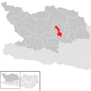
| Location of Lendorf in the Spittal an der Drau district | ||
  |
||
 Church with rectory and parish barn, in which the Teurnia Roman Museum is located. |
||
| Source: Municipal data from Statistics Austria | ||


Lendorf is a municipality with 1703 inhabitants (as of January 1, 2020) in the Spittal an der Drau district in Carinthia .
geography
Lendorf is located on the Lurnfeld and borders in the east on Spittal an der Drau and in the west on the municipality of Lurnfeld . The municipality extends from the Hohe Tauern (Hohe Leier) in the north over the hillside terraces of the Hühnersberg to the bottom of the Drau valley.
Community structure
The community is divided into the two cadastral communities Lendorf and Hühnersberg, the community area comprises the following nine districts (population in brackets as of January 1, 2020):
- Feicht (97)
- Feichtendorf (51)
- Freßnitz (27)
- Chicken Hill (403)
- Lendorf (928)
- Litzlhof (0)
- Rojach (87)
- St. Peter in Wood (86)
- Wind Cord (24)
history
Finds on the Holzer Berg in the district of Sankt Peter in Holz have shown that there were settlements here as early as the Bronze Age .
At the time of the Romans grew here from around 50 BC. The city of Teurnia , which was the capital of the Roman province of Noricum from the 5th century and existed until around the year 600. Extensive excavations have uncovered numerous facilities and finds from this period, which can be seen in the "Museum Teurnia", which opened in 1913.
Teurnia was last mentioned as a bishopric in 591, after which it went under in the course of the Slavic immigration. In the high Middle Ages , the important mother parish of St. Peter in wood was built near the ancient ruins. In the Middle Ages, this church was next to Molzbichl , St. Athanas near Berg im Drautal and Kühweg in Gailtal a place of worship of St. Nonnosus .
A local community in Lendorf was first established in 1850, but was incorporated into Spittal as early as 1864 . On February 12, 1887, Lendorf became independent again and has been an independent municipality ever since.
population
According to the 2001 census, Lendorf has 1,776 inhabitants, 96.1% of whom are Austrian and 1.5% Turkish citizens. 88.0% of the population profess the Roman Catholic , 7.3% the Protestant Church and 1.9% Islam , 4.5% are without religious belief.
Culture and sights
- Museum Teurnia in St. Peter in Holz (Roman excavations)
- Litzlhof
- Parish church of St. Peter in wood
- Filial church Maria am Bichl
Economy and Infrastructure
The community is traditionally strongly influenced by agriculture and has an agricultural college in Litzlhof .
The Drautal Straße (B 100) and a feeder to the Spittal / Millstätter See junction of the Tauern Autobahn (A 10) run through the municipality . From the Drautalbahn , which has a train station in Lendorf, the Tauernbahn branches off at Pusarnitz in the direction of the Tauern tunnel .
politics
Municipal council
The municipal council of Lendorf has 15 members and has been composed as follows since the municipal council election in 2015 :
The directly elected mayor is Marika Lagger-Pöllinger (SPÖ).
coat of arms
The municipal coat of arms of Lendorf shows the motifs of two finds from late antiquity and thus alludes to the importance of Teurnia at that time. The braided tape comes from a barrier plate from the cemetery church, which separated the priestly area from the parish area. The soaring eagle is a motif from the eastern row in the mosaic of the church and a symbol of Christ who protects his children like an eagle in the nest. The T in the clutches of the eagle stands for the submerged Teurnia.
The coat of arms was awarded to the community on May 22, 1987 with the following blazon : “In the black head of the shield a silver, two-stranded, circularly entwined braided ribbon filled with silver rosettes, set off by a silver thread below in red, a silver fly-up, modeled on the mosaic of Teurnia Bird with head turned to the left, holding a silver T in its claws. "
The flag is red and white with an incorporated coat of arms.
Personalities
Sons and daughters of the church
- Josef Gritschacher (1883–1963), politician ( CSP , ÖVP )
- John Lindsay-Theimer (1884–1952), composer of light music
Web links
- Lendorf community
- 20616 - Lendorf (Drautal). Community data, Statistics Austria .
Individual evidence
- ↑ Statistics Austria: Population on January 1st, 2020 by locality (area status on January 1st, 2020) , ( CSV )
- ^ Statistics Austria, population census, demographic data. May 15, 2001, accessed March 3, 2019 .
- ^ Quoted from Wilhelm Deuer: The Carinthian municipal coat of arms . Verlag des Kärntner Landesarchivs, Klagenfurt 2006, ISBN 3-900531-64-1 , p. 168
Bad Kleinkirchheim | Baldramsdorf | Berg im Drautal | Dellach im Drautal | Flattach | Gmünd in Carinthia | Greifenburg | Großkirchheim | Heiligenblut am Großglockner | Irschen | Kleblach-Lind | Krems in Carinthia | Lendorf | Lurnfeld | Mallnitz | Malta | Millstatt am See | Mörtschach | Mühldorf | Oberdrauburg | Obervellach | Radenthein | Rangersdorf | Reisseck | Rennweg am Katschberg | Sachsenburg | Seeboden am Millstätter See | Spittal an der Drau | Stall | Steinfeld | Trebesing | Weissensee | Winklern