
Marloffstein
| coat of arms | Germany map | |
|---|---|---|

|
Coordinates: 49 ° 37 ' N , 11 ° 4' E |
|
| Basic data | ||
| State : | Bavaria | |
| Administrative region : | Middle Franconia | |
| County : | Erlangen-Höchstadt | |
| Management Community : | Uttenreuth | |
| Height : | 355 m above sea level NHN | |
| Area : | 6.62 km 2 | |
| Residents: | 1542 (Dec. 31, 2019) | |
| Population density : | 233 inhabitants per km 2 | |
| Postal code : | 91080 | |
| Area code : | 09131 | |
| License plate : | ERH, HÖS | |
| Community key : | 09 5 72 141 | |
| LOCODE : | DE MSX | |
| Community structure: | 6 districts | |
| Association administration address: | Erlanger Str. 40 91080 Uttenreuth |
|
| Website : | ||
| Mayor : | Eduard Walz (Free voters of the mountain community Marloffstein eV) | |
| Location of the municipality of Marloffstein in the Erlangen-Höchstadt district | ||
  |
||

.jpg)
Marloffstein (colloquially: Moʳlaschdā ) is a municipality in the Central Franconian district of Erlangen-Höchstadt and a member of the Uttenreuth administrative community .
geography
Geographical location
The community is located on a ridge seven kilometers northeast of Erlangen . Because of the proximity to Erlangen and the wide view from the Marloffstein Pass into the Regnitz valley , into Franconian Switzerland and to the south to Nuremberg , the height is a popular destination.
Neighboring communities
Neighboring municipalities are (starting in the north in a clockwise direction):
Langensendelbach , Neunkirchen am Brand , Uttenreuth , Spardorf , Erlangen , Bubenreuth
Community structure
The municipality of Marloffstein has six districts :
- Adlitz
- Atzelsberg
- Marloffstein
- Rathsberg
- Schneckenhof
- Wonder castle
The wasteland of Lug ins Land was in the municipality . The district has been extinct since 1982.
history
As early as 1288 a "Count Herman Celarius de Marrolstein" (Maurolfstein) was mentioned in a document, which is also the first mention of the place. The castle and village were initially the property of the Reichsministeriale von Gründlach and after they died out in 1314/15 they passed to Hohenlohe-Brauneck . This continued the family of Strobel as governors , which also with the neighboring Adlitz and Atzelsberg invested were and residences in Spardorf and Uttenreuth had.
The Wunderburg near Marloffstein was a Streitberg fiefdom until 1690, then a Stauffenberg fiefdom, awarded to patricians from Nuremberg.
The administrative affiliation of the place is closely connected with Marloffstein Castle , which was temporarily the official seat of the administration.

Since 1003 the area belonged to the diocese of Bamberg and was administered as Hofmark .
In 1341 the Hofmark Marloffstein was incorporated into the Hofmark Neunkirchen am Brand . Marloffstein lost his high court (including the associated gallows) but retained the lower jurisdiction .
In 1396, after the official residence was relocated to Schellenberg Castle ( Kleinsendelbach ), the Hofmark Neunkirchen became the Hofmark Schellenberg.
After Schellenberg Castle was destroyed in the Thirty Years' War in 1632 and never rebuilt afterwards, the Marloffstein and Neunkirchen Oberamt was temporarily administered from Regensberg . From 1655 the chief bailiff was back in Marloffstein. The district court was still in Neunkirchen.
At the end of the 18th century there were 34 properties in Marloffstein. The high court was exercised by the Bamberg center office in Neunkirchen . The Marloffsteiner Oberamtmann held the village and community rulership. The Neunkirchen caste office was the sole landlord of all properties (1 castle, 1 half courtyard, the castle property, the adhesive property, 5 goods, 24 houses, the parish hall).
In 1803 the Diocese of Bamberg became part of the Electorate of Bavaria ( Kingdom of Bavaria from 1806 ). The district court of Neunkirchen, which was dissolved again in 1810, became the Oberamt Marloffstein and Neunkirchen .
As part of the municipal edict, Marloffstein was assigned to the tax district and the rural community of Mittelehrenbach in 1808 . With the second community edict (1818) the rural community Marloffstein was formed. In administration and jurisdiction, it was subordinate to the Graefenberg regional court and in financial administration to the Neunkirchen Rent Office . In 1839 Marloffstein was transferred to the regional court and rent office for Forchheim . Wunderburg was moved to Marloffstein after 1840, but before 1861. Lug ins Land was founded in 1854 in the municipality. On October 1, 1857, Marloffstein was transferred to the Erlangen Regional Court and Rent Office ( Erlangen tax office from 1920 ). From 1862 Marloffstein was administered by the Erlangen District Office (renamed the Erlangen District in 1938 ). The jurisdiction remained until 1879 the District Court Erlangen, from 1880 at the district court Erlangen . The community originally had an area of 2.623 km².
Incorporations
On May 1, 1978, the previously independent communities of Adlitz and Atzelsberg were incorporated.
Population development
Marloffstein community
| year | 1827 | 1840 | 1852 | 1861 | 1867 | 1871 | 1875 | 1880 | 1885 | 1890 | 1895 | 1900 | 1905 | 1910 | 1919 | 1925 | 1933 | 1939 | 1946 | 1950 | 1961 | 1970 | 1987 | 2008 | 2013 | 2017 |
|---|---|---|---|---|---|---|---|---|---|---|---|---|---|---|---|---|---|---|---|---|---|---|---|---|---|---|
| Residents | 250 | 310 | 314 | 311 | 336 | 358 | 366 | 371 | 358 | 347 | 344 | 353 | 361 | 353 | 366 | 365 | 404 | 400 | 549 | 514 | 492 | 637 | 1499 | 1623 | 1557 | 1556 |
| Houses | 52 | 52 | 57 | 64 | 80 | 90 | 421 | 563 | ||||||||||||||||||
| source |
Marloffstein municipality
| year | 1827 | 1861 | 1871 | 1885 | 1900 | 1925 | 1950 | 1961 | 1970 | 1987 |
|---|---|---|---|---|---|---|---|---|---|---|
| Residents | 250 | 304 | 349 | 347 | 342 | 357 | 486 | 468 | 629 | 833 |
| Houses | 50 | 55 | 62 | 76 | 88 | 237 | ||||
| source |
politics
Municipal council
The municipality of Marloffstein has twelve members, plus the first mayor.
| CSU | SPD | Free voters of the mountain community Marloffstein eV | Voting group of the mountain community of Marloffstein | total | |
| 2008 | 6th | 2 | 4th | n / A | 12 seats |
| 2014 | 5 | 2 | 5 | n / A | 12 seats |
| 2020 | 4th | 1 | 3 | 4th | 12 seats |
(Status: local election on March 15, 2020 )
mayor
Mayor has been Eduard Walz (Free Voters of the Höhenzugsgemeinde Marloffstein eV) since May 1, 2014. He was confirmed in office in the 2020 local elections.
badges and flags
The municipality of Marloffstein has had a coat of arms since 1982.
|
|
Blazon : “Splitunder the head of the shield, divided by black and silver in a tin cut ; in front a golden lion in red, behind five times diagonally divided by black and gold. "
Yellow and red municipal flag |
| Foundation of the coat of arms: Marloffstein was founded by the Reichsministeriale von Gründlach in the late 12th century. The diagonal division in the rear half of the shield comes from the coat of arms of this noble family . In the 14th century the castle came to the bishops of Bamberg. Until 1802 this was the residence of the Bamberg bailiffs. The lion from the Hochstift coat of arms reminds of this . The head of the shield with the battlements indicates the aristocratic residences of Adlitz, Atzelsberg and Rathsberg in the municipality, which were either directly owned by the Margraves of Brandenburg-Bayreuth. The colors silver and black are the colors of the Zollernvierung and are reminiscent of the margravial rule. |
Architectural monuments
Worth seeing include Marloffstein Castle , Adlitz Castle, Atzelsberg Castle, Rathsberg Castle and the old well.
Soil monuments
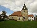
St. James Church

Adlitz Castle

Atzelsberg Castle

Rathsberg Castle

Draw well from 1730


Sports
- TSV Marloffstein
traffic
The national road 2242 goes according Spardorf (1.25 km south west) or via Adlitz according Langensendelbach (2.5 km north). The district road ERH 7 runs past Atzelsberg to Rathsberg (2.5 km west) or to Rosenbach (2.5 km south-east). A community road leads to Ebersbach .
Personalities
- Johann Gottfried Freiherr von und zu Guttenberg (1645–1698) Prince-Bishop of the Würzburg Monastery
- Wolfgang Philipp Freiherr von und zu Guttenberg (1647–1733), German Knight of Malta, Grand Bailiff of the German tongue on Malta
- Gerhard Kittel (1925–2011) physician, phoniatrist and pediatric audiologist
- Günter G. Seip (1935–2017) German engineer, President of the ZVEI, Founding President of the EIBA
- Karl-Heinz Hiersemann (1944–1998) German politician of the SPD, member and vice-president of the Bavarian state parliament
- Elke Sommer (* 1940), German actress
literature
- Ingomar Bog : Forchheim (= Historical Atlas of Bavaria, part of Franconia . I, 5). Komm. Für Bayerische Landesgeschichte, Munich 1955, DNB 450540367 , p. 69 ( digitized version ). Ibid. S. 121 ( digitized version ).
- Johann Kaspar Bundschuh : Marlofstein . In: Geographical Statistical-Topographical Lexicon of Franconia . tape 3 : I-Ne . Verlag der Stettinische Buchhandlung, Ulm 1801, DNB 790364301 , OCLC 833753092 , Sp. 454 ( digitized version ).
- Dorothea Fastnacht: Erlangen: former city and district (= historical book of place names of Bavaria, Middle Franconia . Volume 7 ). Commission for Bavarian State History, Munich 2015, ISBN 978-3-7696-6869-8 , p. 191-198 .
- August Gebeßler : City and district of Erlangen (= Bavarian art monuments . Volume 14 ). Deutscher Kunstverlag, Munich 1962, DNB 451450949 , p. 135-136 .
- Bertold Frhr. von Haller: Marloffstein . In: Christoph Friederich, Bertold Freiherr von Haller, Andreas Jakob (Hrsg.): Erlanger Stadtlexikon . W. Tümmels Verlag, Nuremberg 2002, ISBN 3-921590-89-2 , p. 481 f . ( Complete edition online ).
- Franz Krug (ed.): The district of Erlangen-Höchstadt . Publishing house for authorities a. Wirtschaft, Hof (Saale) 1979, ISBN 3-921603-00-5 , p. 155-156 .
- Manfred Mayer: Marloffstein 1288–1988. History, records, narratives . Druckhaus und Verlag Mayer, Erlangen, 1988, 319 pp.
- Wolf-Armin von Reitzenstein : Lexicon of Franconian place names. Origin and meaning . Upper Franconia, Middle Franconia, Lower Franconia. CH Beck, Munich 2009, ISBN 978-3-406-59131-0 , p. 144-145 .
Web links
- Marloffstein in the Topographia Franconiae of the University of Würzburg , accessed on September 27, 2019.
- Marloffstein: Official statistics of the LfStat
Individual evidence
- ↑ "Data 2" sheet, Statistical Report A1200C 202041 Population of the municipalities, districts and administrative districts 1st quarter 2020 (population based on the 2011 census) ( help ).
- ↑ D. Fastnacht, p. 196.
- ^ Community of Marloffstein in the local database of the Bayerische Landesbibliothek Online . Bayerische Staatsbibliothek, accessed on September 27, 2019.
- ↑ Bertold Freiherr von Haller: Article about Marloffstein in the Erlanger Stadtlexikon , [1]
- ↑ Bertold Freiherr von Haller: Article about the von Strobel family in the Erlanger Stadtlexikon , [2]
- ↑ According to W.-A. v. Reitzenstein, p. 144 f., First documented mention in 1302 as "Movrolfstein". The defining word of the place name is the personal name Maorolf, Morolf .
- ↑ www.dieter-zoeberlein.de, Die von Streitberg, History of a Franconian Aristocratic Family (accessed on October 19, 2018)
- ^ A b c Franz Wenceslaus Goldwitzer (chaplain): History of the market in Neunkirchen am Brand and the former monastery: with consideration for the parish there; together with a topography; in three compartments; with two and thirty supplements as an attempt at a local story , Erlangen, 1814 on books.google.de
- ↑ nordbayern.de, Nürnberg, Germany: From proud castle to small village . ( nordbayern.de [accessed October 29, 2018]).
- ↑ I. Bog, p. 69.
- ^ I. Bog, p. 121.
- ↑ a b c Bavarian State Statistical Office (ed.): Official city directory for Bavaria, territorial status on October 1, 1964 with statistical information from the 1961 census . Issue 260 of the articles on Bavaria's statistics. Munich 1964, DNB 453660959 , Section II, Sp. 772 ( digitized version ).
- ^ Federal Statistical Office (ed.): Historical municipality directory for the Federal Republic of Germany. Name, border and key number changes in municipalities, counties and administrative districts from May 27, 1970 to December 31, 1982 . W. Kohlhammer, Stuttgart / Mainz 1983, ISBN 3-17-003263-1 , p. 711 .
- ↑ a b Only inhabited houses that were designated as residential buildings are given.
- ^ A b Karl Friedrich Hohn (Hrsg.): Geographical-statistical description of the Upper Main district . J. Dederich, Bamberg 1827, p. 125 ( digitized version ).
- ↑ a b c d e f g h i j k l m Bavarian State Statistical Office (Hrsg.): Historical municipality register: The population of the municipalities of Bavaria from 1840 to 1952 (= contributions to Statistics Bavaria . Issue 192). Munich 1954, DNB 451478568 , p. 170 , urn : nbn: de: bvb: 12-bsb00066439-3 ( digitized version ).
- ↑ a b Joseph Heyberger, Chr. Schmitt, v. Wachter: Topographical-statistical manual of the Kingdom of Bavaria with an alphabetical local dictionary . In: K. Bayer. Statistical Bureau (Ed.): Bavaria. Regional and folklore of the Kingdom of Bavaria . tape 5 . Literary and artistic establishment of the JG Cotta'schen Buchhandlung, Munich 1867, Sp. 1016 , urn : nbn: de: bvb: 12-bsb10374496-4 ( digitized version ).
- ↑ a b Kgl. Statistical Bureau (ed.): Complete list of localities of the Kingdom of Bavaria. According to districts, administrative districts, court districts and municipalities, including parish, school and post office affiliation ... with an alphabetical general register containing the population according to the results of the census of December 1, 1875 . Adolf Ackermann, Munich 1877, 2nd section (population figures from 1871, cattle figures from 1873), Sp. 1182 , urn : nbn: de: bvb: 12-bsb00052489-4 ( digitized version ).
- ↑ a b K. Bayer. Statistical Bureau (Ed.): Localities directory of the Kingdom of Bavaria. According to government districts, administrative districts, ... then with an alphabetical register of locations, including the property and the responsible administrative district for each location. LIV. Issue of the contributions to the statistics of the Kingdom of Bavaria. Munich 1888, Section III, Sp. 1113 ( digitized version ).
- ↑ a b K. Bayer. Statistical Bureau (Ed.): Directory of localities of the Kingdom of Bavaria, with alphabetical register of places . LXV. Issue of the contributions to the statistics of the Kingdom of Bavaria. Munich 1904, Section II, Sp. 1180 ( digitized version ).
- ↑ a b Bavarian State Statistical Office (ed.): Localities directory for the Free State of Bavaria according to the census of June 16, 1925 and the territorial status of January 1, 1928 . Issue 109 of the articles on Bavaria's statistics. Munich 1928, Section II, Sp. 1218 ( digitized version ).
- ↑ a b Bavarian State Statistical Office (ed.): Official place directory for Bavaria - edited on the basis of the census of September 13, 1950 . Issue 169 of the articles on Bavaria's statistics. Munich 1952, DNB 453660975 , Section II, Sp. 1051 ( digitized version ).
- ↑ a b Bavarian State Statistical Office (Hrsg.): Official local directory for Bavaria . Issue 335 of the articles on Bavaria's statistics. Munich 1973, DNB 740801384 , p. 173 ( digitized version ).
- ↑ a b Bavarian State Office for Statistics and Data Processing (Ed.): Official local directory for Bavaria, territorial status: May 25, 1987 . Issue 450 of the articles on Bavaria's statistics. Munich November 1991, DNB 94240937X , p. 335 ( digitized version ).
- ↑ a b c LfStat : Marloffstein: Official statistics. In: statistik.bayern.de. Pp. 6 and 12 , accessed on November 5, 2019 .
- ^ Entry on the coat of arms of Marloffstein in the database of the House of Bavarian History
- ↑ Marloffstein. In: Kommunalflaggen.eu. Retrieved July 9, 2020 .
- ^ Official website of Elke Sommer ; accessed on September 20, 2018

Adelsdorf | Aurachtal | Baiersdorf | Bubenreuth | Buckenhof | Eckental | Gremsdorf | Großenseebach | Hemhofen | Heroldsberg | Herzogenaurach | Hessdorf | Höchstadt an der Aisch | Kalchreuth | Lonnerstadt | Marloffstein | Möhrendorf | Mulhouse | Oberreichenbach | Röttenbach | Savings Village | Uttenreuth | Vestenbergsgreuth | Wachenroth | Weisendorf
Unregulated areas in the district of Erlangen-Höchstadt
Birkach |
Buckenhofer Forest |
Dormitzer Forest |
Erlenstegen Forest |
Forest Tennenlohe |
Geschaidt |
Kalchreuther Forest |
Kraftshofer Forest |
Mark |
Neunhofer Forest