
Herzogenaurach
| coat of arms | Germany map | |
|---|---|---|

|
Coordinates: 49 ° 34 ' N , 10 ° 53' E |
|
| Basic data | ||
| State : | Bavaria | |
| Administrative region : | Middle Franconia | |
| County : | Erlangen-Höchstadt | |
| Height : | 301 m above sea level NHN | |
| Area : | 47.62 km 2 | |
| Residents: | 23,373 (Dec. 31, 2019) | |
| Population density : | 491 inhabitants per km 2 | |
| Postal code : | 91074 | |
| Area code : | 09132 | |
| License plate : | ERH, HÖS | |
| Community key : | 09 5 72 132 | |
| City structure: | 19 parts of the community | |
City administration address : |
Marktplatz 11 91074 Herzogenaurach |
|
| Website : | ||
| Mayor : | German Hacker ( SPD ) | |
| Location of the city of Herzogenaurach in the Erlangen-Höchstadt district | ||
  |
||

.jpg)
Herzogenaurach is a Franconian city in the Central Franconian district of Erlangen-Höchstadt and is located on the Middle Aurach .
geography
The city is located west of Erlangen and Nuremberg within the Nuremberg Metropolitan Region .
Neighboring communities
Neighboring communities are:
| Weisendorf | Großenseebach , Heßdorf | |
| Aurach Valley |
.svg)
|
gain |
| Emskirchen | Obermichelbach , Tuchenbach , Puschendorf |
City structure
There are six districts and 19 officially named districts , 14 of which are inhabited:
|
|

history


Until the 19th century
Originally the settlement was called "Uraha", which meant for example cattle trough on the river (ur for cattle, aha for flowing water). This later became Aurach, a place and river name that is common in Bavaria. To distinguish it from many other places of the same name, it became Herzogenaurach, possibly because of the dukes of Andechs-Meranien , who were wealthy there in the Middle Ages. The settlement emerged from a Frankish royal court .
The place was first mentioned in 1002 as "Uraha", when King Heinrich II , the later German Emperor, gave the settlement together with other settlements, including Erlangen, to the Haug monastery in Würzburg . In this document the words "pertinens at Uraha" appear (bordering on Uraha) and forest bee care carried out on Zeidel pastures is mentioned. "aqumque pascius pue vulgo dicuntur (which are called) cidaluueidis" (bee pastures). The beekeeping industry in Herzogenaurach therefore already existed in 1002 and was mentioned in a document accordingly.
Just nine years later, Herzogenaurach came to the Bamberg Monastery . In 1228 the city became the seat of a Bamberg bailiff who moved into his residence in the newly built castle. In the following centuries the city grew and developed into a center of the cloth-making trade , in 1450 the city fortifications were expanded. Herzogenaurach was hit several times by plague epidemics, in the 17th century the city suffered from the Thirty Years' War. According to data from the Society for Leprology in Herzogenaurach is a medieval leper detectable, which was "out of town". The year it was founded is unclear, in 1706 the leprosy was in disrepair.
At the end of the 18th century there were 203 properties in Herzogenaurach. The high court exercised the Bamberg center office Herzogenaurach . The village and community rulership held office and city council Herzogenaurach. The landlords were the Bamberg caste office in Herzogenaurach (castle, 5 church buildings, a hospital, 3 public buildings, 4 taverns, 181 houses, 2 baths, 1 mill, 2 forges) and the Nuremberg hospital office (1 courtyard and Zehentstadel).
In 1803, the prince-bishopric of Bamberg, which belonged to the Franconian Empire from 1500 , was dissolved in the course of secularization and initially fell to Prussia . After three years of foreign rule by France, the former territory of the prince-bishopric with the city of Herzogenaurach became part of the Kingdom of Bavaria in 1810 .
As part of the municipal edict , the Herzogenaurach tax district was formed in 1811 , to which Eichelmühle , Haundorf , Heinrichsmühle , Lohhof and Niederndorf belonged. With the second community edict (1818), the places were assigned to the following newly formed communities:
- Haundorf rural community
- Municipal municipality with magistrate III. Herzogenaurach class with acorn and Heinrich mill
- Rural community of Niederndorf with Lohhof.
The administration and jurisdiction of the municipality of Herzogenaurach was subordinate to the district court of Herzogenaurach and the financial administration to the Erlangen tax office . On October 1, 1847, the financial management was taken over by the Rentamt Herzogenaurach . From 1862, Herzogenaurach was administered by the district office of Höchstadt an der Aisch (renamed the district of Höchstadt an der Aisch in 1938 ) and continued to be administered by the Herzogenaurach Rent Office (1920–1929: Herzogenaurach tax office , from 1929: Erlangen tax office ). The jurisdiction remained with the district court of Herzogenaurach until 1879, 1880–1959 district court of Herzogenaurach , from 1959 district court of Erlangen . The community originally had an area of 12.522 km².
In the 20th century, the shoe and clothing industry in particular developed in Herzogenaurach. After the Second World War, the two sports shoe and clothing groups adidas and Puma were founded.
20th and 21st centuries
On July 1, 1972, Herzogenaurach and the new district of Erlangen-Höchstadt were incorporated into the Central Franconia administrative region . In 2002, Herzogenaurach celebrated its millennial city anniversary.
Herzogenaurach is the largest city in the Erlangen-Höchstadt district and, thanks to its well-known companies, is an important business location in Germany with many jobs.
Incorporations
On January 1, 1972, the previously independent municipality of Burgstall and parts of the municipality of Hammerbach were incorporated. Zweifelsheim was added on July 1, 1972. Haundorf followed on January 1, 1974. Finally, on May 1, 1978, Niederndorf and a small part of the Aurachtal community ( Dondörflein and Eckenmühle with about 50 inhabitants at that time) were added.
Population statistics
Herzogenaurach community
| year | 1972 | 1978 | 1987 | 1991 | 1995 | 1999 | 2005 | 2010 | 2015 | 2016 | 2017 |
|---|---|---|---|---|---|---|---|---|---|---|---|
| Residents | 13939 | 16349 | 18451 | 20910 | 22534 | 23125 | 22875 | 23050 | 23095 | 23081 | 23098 |
| Houses | 4014 | 5805 | 5822 | 5846 | |||||||
| source |
District of Herzogenaurach with oak and Heinrichsmühle (= municipality of Herzogenaurach until 1972)
| year | 1818 | 1840 | 1852 | 1855 | 1861 | 1867 | 1871 | 1875 | 1880 | 1885 | 1890 | 1895 | 1900 | 1905 | 1910 | 1919 | 1925 | 1933 | 1939 | 1946 | 1950 | 1952 | 1961 | 1970 | 1987 | 2019 |
|---|---|---|---|---|---|---|---|---|---|---|---|---|---|---|---|---|---|---|---|---|---|---|---|---|---|---|
| Residents | 1468 | 1863 | 1981 | 1931 | 1865 | 1940 | 2062 | 2174 | 2520 | 2533 | 2531 | 2623 | 2823 | 3159 | 3313 | 3357 | 3710 | 4059 | 4940 | 6568 | 7174 | 7707 | 9941 | 12450 | 13416 | 16938 |
| Houses | 215 | 279 | 319 | 346 | 486 | 737 | 1208 | 5265 | ||||||||||||||||||
| source |

Denomination statistics
According to the 2011 census , 47.5% of the population were Roman Catholic , 26.4% Protestant, and 26.1% were non-denominational , belonged to another religious community or did not provide any information. The number of Protestants and Catholics has fallen since then. In July 2020, of the 24,975 inhabitants, 9,652 (38.6%) are Roman Catholic, 5,511 (22.1%) are Protestant, and 9,822 (39.3%) are non-denominational or belong to another religious community.
military
In the course of armament and war preparations during the Nazi era, a military airfield was set up in 1934 on the formerly agricultural area of Bei der Zweimarterlinde , which the Wehrmacht expanded until 1940. The air base was set up as a "peace location". The core was an airfield (670 meters in north-south direction, 915 meters in east-west direction), which was paved with bricks and overgrown with grass; the longest taxi route was about a thousand meters.
Towards the end of the Second World War, parts of the Panzerschreck were assembled in the factories of the shoe manufacturers Adolf and Rudolf Dassler - later Adidas and Puma .
The last close-up reconnaissance squadron left Herzogenaurach in March 1945, and Fighter Wing 104 was withdrawn in April 1945 because of the rapidly advancing American ground troops . The Wehrmacht had prepared to blow up the buildings, but it was not carried out. When American units occupied Herzogenaurach on April 16, only one hangar and two wooden barracks at the air base were destroyed.
The Allied troops had refrained from bombing the air base , the location and facilities of which were known to the Royal Air Force in detail. It is believed that it was intended for use by the Allies. The US Army took over the site in 1945 and used it as a military base for artillery. In 1990/91 the American troops stationed in Herzogenaurach were assigned to a war mission. By January 15, 1992, the withdrawal of the 210th Artillery Brigade had been completed; Around 400 soldiers of the 5th Battalion of the 17th Field Artillery dissolved the site by March 16, 1992. Today the headquarters of Adidas AG are located there.
Attractions

lock

City parish church

Old Town Hall
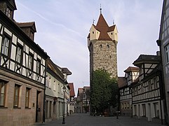
Main street with Fehnturm


The baroque castle , which served as the residence of the bailiffs of the Bamberg prince-bishopric, was built in 1720 on the site of a medieval complex that was destroyed in the Thirty Years War. The Herzogenaurach town hall was added to the castle in 1967. The city library and tourist information are also located in the castle. This extension was demolished in 2019 and will be replaced by a modern new town hall by 2022.
The core of the old town hall dates from the Middle Ages. In addition to the council and the court, the building also housed the bread and meat market and the city's arsenal. The police were also housed here until April 2003. In 2005 the old town hall was completely renovated and now houses a restaurant.
The city's two gate towers from the 13th century are visible from afar. The Türmersturm in the west of the old town can be recognized by its rounded tower dome and its four tower clocks. The Fehnturm with its four side watchtowers in the east of the old town is named after the former gatekeeper family and was used as a city prison and city treasury. The two towers used to be part of the city wall, which was gradually dismantled from 1825.
The Catholic parish church of St. Magdalena is located a little off the central main street and was also outside the city wall until the end of the 15th century. The church is a high Gothic hall church with baroque furnishings, with the choir dating from the 13th century. The extremely wide nave is spanned by a large, wooden barrel vault.
In the vicinity of the parish church is the Pfründner hospital from 1508 (today the city museum ), the classicistic rectory and the Marienkapelle built around 1200 . At the entrance from the main street to the parish church is the Kiliansbrunnen , which has existed as a spring since the Middle Ages and where, according to legend, the Franconian apostle Kilian preached in 686 .
In addition to the sights already mentioned, the old town has numerous medieval half-timbered houses, especially in the area of the main street, the church square and the historic market square.
politics
City council
The city council of Herzogenaurach consists of 30 city council members and the first mayor as a member of the city council.
In the 2014–2020 term of office there was cooperation between the SPD and the Greens.
On April 4, 2020, the members of the SPD, Die Grünen, FDP and DIE PARTTEI signed a cooperation agreement and formed a majority for the 2020–2026 city council period.
| choice | SPD | CSU | Green | Free voters | FDP | Others | |||||||
|---|---|---|---|---|---|---|---|---|---|---|---|---|---|
| Elective | Result | Seats | Result | Seats | Result | Seats | Result | Seats | Result | Seats | Result | Seats | |
| 2002 | 10 | 15 + 1 | 1 | 1 | 1 | BfB | 2 | ||||||
| 2008 | 65.92% | 40.04% | 13 + 1 | 36.89% | 11 | 6.62% | 2 | 6.61% | 2 | 5.03% | 1 |
BfB
4.90% |
1 |
| 2014 | 57.25% | 42.37% | 13 + 1 | 34.93% | 10 | 11.82% | 4th | 6.66% | 2 | 4.22 | 1 | ||
| 2020 | 61.75% | 26.34% | 8 + 1 | 28.14% | 8th | 16.79% | 5 | 12.27% | 4th | 3.28% | 1 |
JU
6.52% POLITICAL PARTY 3.49 AfD 3.17% |
2
|
mayor
First mayor of Herzogenaurach since 1945:
- 1945–1970: Hans Maier (SPD)
- 1970–1990: Hans Ort (CSU)
- 1990-2008: Hans Lang (CSU)
- since 2008: German Hacker (SPD)
In the 2014–2020 term of office, Renate Schroff (SPD) was second mayor, third mayor was Georgios Halkias (Bündnis 90 / Die Grünen).
Since May 7, 2020, the Green Georgios Halakias has been the second mayor and Michael Dassler (FDP) is the third mayor. It caused displeasure among some that the city council with the fewest votes was elected to the office of 3rd mayor.
| Political party | candidate | 1st ballot | 2nd ballot |
|---|---|---|---|
| Local election 2008 | |||
| SPD | German hacker | 58.1% | - |
| CSU | Walter Nussel | 31.9% | - |
| Green | Retta Müller-Schimmel | 1.1% | - |
| Free voters | Manfred Welker | 4.1% | - |
| FDP | Britta Dassler | 3.7% | - |
| Local election 2014 | |||
| SPD | German hacker | 67.0% | - |
| CSU | Matthias Düthorn | 21.4% | - |
| Green | Peter Maier | 4.0% | - |
| Free voters | Manfred Welker | 6.0% | - |
| FDP | Ralf Markert | 1.6% | - |
| Local election 2020 | |||
| SPD | German hacker | 48.8% | 64.3% |
| CSU | Sabine Hanisch | 18.4% | 35.7% |
| Green | Georgios Halkias | 10.1% | - |
| Free voters | Manfred Welker | 17.1% | - |
| FDP | Michael Dassler | 2.4% | - |
| THE PARTY | Steffen Moroskow | 3.2% | - |
badges and flags
Herzogenaurach has had a coat of arms since the 14th century.
|
|
Blazon : "In gold, a red armored black lion covered with a silver sloping bar."
Yellow and black municipal flag |
| Founding of the coat of arms: The former royal court of Herzogenaurach belonged to the Bamberg diocese from 1021 to 1803 . An imprint of a seal with the Bamberg lion has come down to us from 1343 . Since then it has been in all seals, in a shield or free. In depictions of seals from the 17th century, the lion sits riding on the sloping beam. |
Town twinning
Herzogenaurach maintains partnerships with the following cities:
-
 Wolfsberg ( Austria ), since 1968
 -
 Kaya ( Burkina Faso ), since 1972
 -
 Nova Gradiška ( Croatia ), since 1980
 -
 Sainte-Luce-sur-Loire ( France ), since 1988
Economy and Infrastructure
traffic
Street
Herzogenaurach is located directly on the highway A 3 at the junction of Erlangen-Frauenaurach. The A 73 motorway can be reached from Herzogenaurach in 10 to 15 minutes.
The national road 2244 runs north around Herzogenaurach and low village. It leads west via Falkendorf and Münchaurach to a junction of the federal road 8 near Emskirchen or east to junction 82 of the A 3 and on to Frauenaurach to Bruck to state road 2242 . The state road 2263 runs northwest over Welkenbach to Hammerbach or east over Niederndorf and Neuses to the St 2244. The district road ERH 14 runs from the St 2244 north to Beutelsdorf or from the St 2263 southwest to Dondörflein . A community road runs south to Burgstall .
rail
The nearest train stop is Puschendorf on the Nuremberg – Würzburg railway line , the distance to the city center is around 6 kilometers. Puschendorf can be reached by bus line 123 in 14 minutes. The nearest long-distance train station is about 9 kilometers away in Erlangen , there is bus line 201 of Omnibusverkehr Franken (OVF) with a journey time of about 30 minutes. The bus routes operated by Herzo Bäder- und Verkehrs GmbH operate in the city. The Erlangen-Bruck-Herzogenaurach railway line , which was in operation from 1894 to 1984, is largely still there, but no longer passable. The planning of a siding to the closer Nuremberg-Würzburg railway via Obermichelbach was rejected in 1883.
According to current (2020) planning, the city-surrounding railway Erlangen will connect Herzogenaurach to Nuremberg via Erlangen. The reactivation of the Aurachtalbahn was also brought back into discussion by the cooperation agreement of the new city government. The StUB project should not be affected by this.
aviation
The Herzogenaurach airfield is located north of the city center . A 700 meter long runway enables air traffic for aircraft up to 3700 kg takeoff weight.
Hiking trails
The Franconian Marienweg runs through Herzogenaurach .
Established businesses


Herzogenaurach is the headquarters of Adidas and Puma as well as the Schaeffler Group .
Adidas and Puma, two of the world's largest sporting goods manufacturers, have made the city a nationwide center of attraction for sporting goods. In the area of the northern bypass (Hans-Ort-Ring) there are large factory outlets from Adidas, Puma, s.Oliver, Nike and a large sports shop.
The Schaeffler Group, a manufacturer of roller and plain bearings, engine elements and linear technology, which in addition to its headquarters also has research, development and production in the city, gained special public attention from July 2008 through the takeover battle for the much larger Continental AG .
education
Herzogenaurach has three primary schools , two secondary schools , a support center , a vocational school specializing in metal technology and business / administration, a state secondary school and a grammar school , which emerged in 1978 from a branch of the Höchstadt grammar school and, like the mother school, is a natural science, technological and linguistic grammar school .
Hospitals
The Herzogenaurach Clinic for Physical Medicine and Medical Rehabilitation, part of the m & i Clinic Group Enzensberg, is located in the west of the city on the bypass road .
media
Herzogenaurach has its own television station with Herzo.TV. There are regional editions for Herzogenaurach of the two local daily newspapers, Nordbayerische Nachrichten and Fränkischer Tag .
Culture and leisure

Museums
- The city museum in the Pfründnerspital was opened in autumn 2000 in the former hospital of the Holy Spirit on Kirchenplatz.
- The Nativity Scene Museum is open from the first Sunday in October until Easter of the following year.
Regular events
- Old town festival
- hin & herzo cultural festival
- Ökofest
- Run for Kaya! (every two years since 2005)
- Baserock (until 2009: U-Turn Festival)
- Summer church fair
- School's Out Festival
- Medieval Festival
- Martini parish fair
- Hobby artist market
- Christmas Market
- Public viewing (Adidas Outlet)
- White night of the advertising community
leisure
The city has a large municipal outdoor pool in the immediate vicinity of the old town and the Atlantis leisure pool , a large leisure pool with extensive water and sauna facilities in the west of the city, as well as the rabatz youth center .
Soccer World Cup 2006 and EM 2020
During the 2006 World Cup, the Argentine national soccer team was based in Herzogenaurach. For the 2020 European Football Championship, which has now been postponed by a year, the German national team had planned to move into their team quarters in Herzogenaurach.
Personalities
Honorary citizen
sons and daughters of the town
- Hieronymus Nopp (around 1495–1541), Protestant theologian, scholar and reformer from Regensburg
- Veit Ludwig von Seckendorff (1626–1692), scholar and statesman
- Anna Herrmann (1892–1980), local politician
- Rudolf Dassler (1898–1974), entrepreneur, Puma founder
- Adolf Dassler (1900–1978), entrepreneur, adidas founder
- Elmar Klinger (* 1938), fundamental theologian
- Lutz Braun (* 1966), soccer player
- Mareike Wiening (* 1987), jazz musician
Personalities associated with the city
- Otto Brixner (* 1943), presiding judge in the criminal case against Gustl Mollath , lives in the Niederndorf district
- Lothar Matthäus (* 1961), soccer player, national record player
- Günter Güttler (* 1961), soccer player
- Mathias Hartmann (* 1966), German pastor, rector and chairman of the Diakonie Neuendettelsau
literature
- Johann Kaspar Bundschuh : Herzogenaurach . In: Geographical Statistical-Topographical Lexicon of Franconia . tape 2 : El-H . Verlag der Stettinische Buchhandlung, Ulm 1800, DNB 790364298 , OCLC 833753081 , Sp. 636-642 ( digitized version ).
- Georg Daßler (Ed.): District of Höchstadt ad Aisch. Past and present . Verl. F. Authorities and Wirtschaft Hoeppner, Aßling-Munich 1970, DNB 457004320 , p. 77-81 .
- Hanns Hubert Hofmann : Höchstadt-Herzogenaurach (= Historical Atlas of Bavaria, part Franconia . I, 1). Commission for Bavarian State History, Munich 1951, DNB 452071143 , p. 69 ( digitized version ). Ibid. S. 143 ( digitized version ).
- Franz Krug (ed.): The district of Erlangen-Höchstadt . Publishing house for authorities a. Wirtschaft, Hof (Saale) 1979, ISBN 3-921603-00-5 , p. 115-124 .
- Wolf-Armin von Reitzenstein : Lexicon of Franconian place names. Origin and meaning . Upper Franconia, Middle Franconia, Lower Franconia. CH Beck, Munich 2009, ISBN 978-3-406-59131-0 , p. 101 .
- Pleikard Joseph Stumpf : Herzogenaurach . In: Bavaria: a geographical-statistical-historical handbook of the kingdom; for the Bavarian people . Second part. Munich 1853, p. 588 ( digitized version ).
Web links
- City website
- Herzogenaurach in the Topographia Franconiae of the University of Würzburg , accessed on September 27, 2019.
- Herzogenaurach: Official statistics of the LfStat
Individual evidence
- ↑ "Data 2" sheet, Statistical Report A1200C 202041 Population of the municipalities, districts and administrative districts 1st quarter 2020 (population based on the 2011 census) ( help ).
- ^ Municipality of Herzogenaurach in the local database of the Bavarian State Library Online . Bayerische Staatsbibliothek, accessed on September 27, 2019 .. 18 parts of the community there, as Herzo Base was not taken into account.
- ↑ a b c d e f g City of Herzogenaurach: Figures ( Memento from April 11, 2007 in the Internet Archive )
- ↑ Herzogenaurach in figures, population figures by part of the municipality , source: City of Herzogenaurach, status: January 2017 (accessed on May 16, 2017, figures from the population register )
- ↑ a b W.-A. v. Reitzenstein, p. 101.
- ↑ Erik Busch, et. al .: Beekeeping in Herzogenaurach . Ed .: Beekeeping Association Herzogenaurach. 1st edition. epubli.de, Berlin 2020, ISBN 978-3-7529-6822-4 , pp. 88 .
- ↑ See Medieval Leprosories in Today's Bavaria, Documentation, in: Die Klapper 1995, accessed February 10, 2018 ( Memento of the original from March 4, 2016 in the Internet Archive ) Info: The archive link was inserted automatically and has not yet been checked. Please check the original and archive link according to the instructions and then remove this notice.
- ^ HH Hofmann, p. 69.
- ^ Address and statistical manual for the Rezatkreis in the Kingdom of Baiern . Buchdruckerei Chancellery, Ansbach 1820, p. 49 ( digitized version ).
- ^ HH Hofmann, p. 143.
- ↑ a b Bavarian State Statistical Office (ed.): Official city directory for Bavaria, territorial status on October 1, 1964 with statistical information from the 1961 census . Issue 260 of the articles on Bavaria's statistics. Munich 1964, DNB 453660959 , Section II, Sp. 679 ( digitized version ).
- ^ City of Herzogenaurach: From the 1000 year history of the city of Herzogenaurach. ( Memento of the original from March 31, 2013 in the Internet Archive ) Info: The archive link was inserted automatically and has not yet been checked. Please check the original and archive link according to the instructions and then remove this notice. (PDF)
- ^ Wilhelm Volkert (ed.): Handbook of Bavarian offices, communities and courts 1799–1980 . CH Beck, Munich 1983, ISBN 3-406-09669-7 , p. 484 .
- ^ Federal Statistical Office (ed.): Historical municipality directory for the Federal Republic of Germany. Name, border and key number changes in municipalities, counties and administrative districts from May 27, 1970 to December 31, 1982 . W. Kohlhammer, Stuttgart / Mainz 1983, ISBN 3-17-003263-1 , p. 711 and 712 .
- ↑ a b Only inhabited houses are given. In 1818 these were called fire places, from 1871 to 2017 as residential buildings.
- ↑ a b Bavarian State Office for Statistics and Data Processing (Ed.): Official local directory for Bavaria, territorial status: May 25, 1987 . Issue 450 of the articles on Bavaria's statistics. Munich November 1991, DNB 94240937X , p. 335 ( digitized version ).
- ↑ a b c d LfStat : Herzogenaurach: Official statistics. (PDF) In: statistik.bayern.de. Pp. 6 and 12 , accessed on October 9, 2019 .
- ↑ Alphabetical index of all the localities contained in the Rezatkkreis according to its constitution by the newest organization: with indication of a. the tax districts, b. Judicial Districts, c. Rent offices in which they are located, then several other statistical notes . Ansbach 1818, p. 40 ( digitized version ). For the municipality of Herzogenaurach plus the residents and fireplaces of Eichenmühle (p. 21) and Heinrichsmühle (p. 38).
- ↑ a b c d e f g h i j k l m n o Bavarian State Statistical Office (Hrsg.): Historical municipality register: The population of the municipalities of Bavaria from 1840 to 1952 (= contributions to Statistics Bavaria . Issue 192). Munich 1954, DNB 451478568 , p. 145 , urn : nbn: de: bvb: 12-bsb00066439-3 ( digitized version ).
- ^ Joseph Heyberger, Chr. Schmitt, v. Wachter: Topographical-statistical manual of the Kingdom of Bavaria with an alphabetical local dictionary . In: K. Bayer. Statistical Bureau (Ed.): Bavaria. Regional and folklore of the Kingdom of Bavaria . tape 5 . Literary and artistic establishment of the JG Cotta'schen Buchhandlung, Munich 1867, Sp. 876–877 , urn : nbn: de: bvb: 12-bsb10374496-4 ( digitized version ).
- ↑ Kgl. Statistical Bureau (ed.): Complete list of localities of the Kingdom of Bavaria. According to districts, administrative districts, court districts and municipalities, including parish, school and post office affiliation ... with an alphabetical general register containing the population according to the results of the census of December 1, 1875 . Adolf Ackermann, Munich 1877, 2nd section (population figures from 1871, cattle figures from 1873), Sp. 1049-1050 , urn : nbn: de: bvb: 12-bsb00052489-4 ( digital copy ).
- ↑ K. Bayer. Statistical Bureau (Ed.): Localities directory of the Kingdom of Bavaria. According to government districts, administrative districts, ... then with an alphabetical register of locations, including the property and the responsible administrative district for each location. LIV. Issue of the contributions to the statistics of the Kingdom of Bavaria. Munich 1888, Section III, Sp. 994 ( digitized version ).
- ↑ K. Bayer. Statistical Bureau (Ed.): Directory of localities of the Kingdom of Bavaria, with alphabetical register of places . LXV. Issue of the contributions to the statistics of the Kingdom of Bavaria. Munich 1904, Section II, Sp. 1043 ( digitized version ).
- ↑ Bavarian State Statistical Office (ed.): Localities directory for the Free State of Bavaria according to the census of June 16, 1925 and the territorial status of January 1, 1928 . Issue 109 of the articles on Bavaria's statistics. Munich 1928, Section II, Sp. 1077 ( digitized version ).
- ↑ Bavarian State Statistical Office (ed.): Official place directory for Bavaria - edited on the basis of the census of September 13, 1950 . Issue 169 of the articles on Bavaria's statistics. Munich 1952, DNB 453660975 , Section II, Sp. 923 ( digitized version ).
- ^ Bavarian State Statistical Office (ed.): Official place directory for Bavaria . Issue 335 of the articles on Bavaria's statistics. Munich 1973, DNB 740801384 , p. 173 ( digitized version ).
- ↑ Numbers and facts on the website herhabenaurach.de
- ^ City of Herzogenaurach Religion , 2011 census
- ↑ Population by religious affiliation , accessed on July 19, 2020
- ↑ mirror - Panzerschreck in the shoe empire
- ↑ [1]
- ↑ [2]
- ↑ Mayor. City of Herzogenaurach, accessed on August 16, 2020 .
- ^ Entry on the coat of arms of Herzogenaurach in the database of the House of Bavarian History
- ↑ Herzogenaurach. In: Kommunalflaggen.eu. Retrieved July 1, 2020 .

Adelsdorf | Aurachtal | Baiersdorf | Bubenreuth | Buckenhof | Eckental | Gremsdorf | Großenseebach | Hemhofen | Heroldsberg | Herzogenaurach | Hessdorf | Höchstadt an der Aisch | Kalchreuth | Lonnerstadt | Marloffstein | Möhrendorf | Mulhouse | Oberreichenbach | Röttenbach | Savings Village | Uttenreuth | Vestenbergsgreuth | Wachenroth | Weisendorf
Unregulated areas in the district of Erlangen-Höchstadt
Birkach |
Buckenhofer Forest |
Dormitzer Forest |
Erlenstegen Forest |
Forest Tennenlohe |
Geschaidt |
Kalchreuther Forest |
Kraftshofer Forest |
Mark |
Neunhofer Forest
Beutelsdorf | Burgstall | Dondörflein | Corner mill | Acorn mill | Galgenhof | Hammerbach | Haundorf | Main village | Heinrichsmühle | Herzo Base | Herzogenaurach | Courtyards | Lohhof | Niederndorf | Grinding mill | Steinbach | Welkenbach | Home of doubt