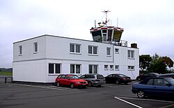
Herzogenaurach airfield
| Herzogenaurach airfield |
|
|---|---|

|
|
| Characteristics | |
| ICAO code | EDQH |
| Coordinates | |
| Height above MSL | 326 m (1070 ft ) |
| Transport links | |
| Distance from the city center | 2 km north of Herzogenaurach, 25 km north-west of Nuremberg |
| Street |
|
| Basic data | |
| opening | October 14, 1962 |
| operator | Herzogenaurach Airfield GmbH |
| Start-and runway | |
| 08/26 | 700 m × 20 m asphalt |
The Herzogenaurach Airport is a commercial airport and is located about two kilometers north of Herzogenaurach .
geography
The airfield is located on the northwestern edge of Herzogenaurach am Birkenbühl at an altitude of 326 m above sea level. NN . In terms of its natural surroundings, it is located on a plateau exposed 30 meters in altitude above the Middle Aurach valley . The Aischgrund lies to the north and the Rangau to the south .
history
The first airfield was built in Herzogenaurach as a military airfield and opened on October 1, 1935. It served to train fighter pilots and from 1939 to 1945 fighter squadrons of the Luftwaffe were stationed there. The approximately one kilometer long grass runway running in an east-west direction was additionally fortified with a brick layer and was located around today's Qlympiaring .
After the occupation by Allied troops in April 1945, the area there became the Herzo Base and the Germans were initially prohibited from flying.
The Aero-Club Herzogenaurach e.V., founded after the flight ban was lifted in 1951 . V. set about looking for a suitable location for a new airfield in 1960, as the air base site was only returned to the Federal Republic of Germany in 1992. This was found in a piece of land about half a kilometer north of the city limits of Herzogenaurach. In autumn 1961, a 700 meter long grass runway was removed by the authorities, but it was not officially inaugurated until October 14, 1962. In 1970 the airfield was expanded into a commercial airfield. In the course of this, the railway, which was opened on June 28, 1970, was paved.
Airfield and equipment
The airfield is for gliders and powered aircraft up to 3700 kg MTOW and for helicopters up to 5700 kg and is usually operated from 9:00 to half an hour after sunset. The owner of the airfield is Flugplatz GmbH Herzogenaurach .
There are several farm buildings, a tower , a hangar, a restaurant and there is a refueling facility.
Incidents
- On March 4, 1963, a Douglas DC-3A-191 ( aircraft registration number N16067 ) rolled over the end of the runway on landing, fell into a ditch and was irreparably damaged. People were not harmed.
- On June 15, 2010, a Piper PA-28-140 Cherokee (D-EFSO) touched down only about 140 to 120 meters before the end of the runway . When trying to leave the runway on a taxiway , the left wing rammed a lamp of the runway lighting , and the machine slipped into a ditch.
- On September 16, 2014, a twin-engine Piper PA-30-160 Twin Comanche (D-GAST) crash-landed , the landing gear of which had not been extended.
- On August 7, 2015, another two-seater propeller plane crashed and landed without extending the landing gear.
traffic
A municipal road opens up the airfield to the five kilometers to the east running federal motorway 3 . The public transport not operated the airfield, the nearest pick-up points consist about 500 meters south of the city bus lines 201, 279 and 273 on the bulk of the route network of regional transport system Nürnberg connect.
Web links
- Flugplatz-Herhabenaurach.de - Official site
- Aero-Club Herzogenaurach e. V.
- Fliegerclub Nürnberg e. V. - Motor flight group
- Airfield information for pilots
- Aviation map for Herzogenaurach Airfield on SkyVector.com
Individual evidence
- ↑ Herzogenaurach Air Base
- ↑ Herzogenaurach Airport 1945 on historical measuring table sheet
- ↑ accident report DC-3 N16067 , Aviation Safety Network (English), accessed on January 26 of 2019.
- ^ BFU: Investigation report. Federal Office for Aircraft Accident Investigation, accessed on December 20, 2019 (German).
- ↑ Press report InFranken.de 2016
- ^ BFU: Bulletin. Federal Bureau of Aircraft Accident Investigation, September 2014, accessed on December 20, 2019 (German).
- ↑ Press report Nordbayern.de 2015


