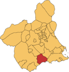
Mazarron
| Mazarrón municipality | ||
|---|---|---|
 Puerto de Mazarron district
|
||
| coat of arms | Map of Spain | |

|
|
|
| Basic data | ||
| Autonomous Community : | Murcia | |
| Province : | Murcia | |
| Comarca : | Bajo Guadalentín | |
| Coordinates | 37 ° 36 ′ N , 1 ° 19 ′ W | |
| Height : | 55 msnm | |
| Area : | 318.7 km² | |
| Residents : | 32,209 (Jan 1, 2019) | |
| Population density : | 101.06 inhabitants / km² | |
| Postal code : | 30 870 | |
| Municipality number ( INE ): | 30026 | |
| administration | ||
| Mayor : | Francisco Blaya Blaya ( PP ) | |
| Website : | www.mazarron.es | |
| Location of the municipality | ||

|
||
Mazarrón is a place in Spain. It is located on the Mediterranean coast in the southeast of the country in the Murcia region between the autonomous region of Valencia and Andalusia .
location
Mazarrón is located in the bay of the same name from Mazarrón between Cabo Tiñoso and Cabo Cope. The place has a fishing port, two marinas, and a large sandy beach (35 km) with a palm promenade and sheltered bays. The mountainous hinterland, which is up to 600 m high, delimits the town, which is about 2.5 km from the coast, to the north. The center of Mazarrón is a few kilometers from the coast, the districts of Puerto de Mazarrón and Bolnuevo are directly on the coast.
history
Rock paintings in the area testify to a prehistoric settlement. In addition, buildings from Roman times, Arab fortifications and churches from the Romanesque and Gothic epochs demonstrate a varied historical significance. Wrecks of Phoenician ships have also been found off the coast .
Attractions
Mention should be made of the town hall from the 19th century, which is a national historical-artistic building under monument protection. The "San Andrés" church, the tower of the "Santa Elena" church, the tower of "Santa Isabel", the tower "de los Caballo", the castle de "Los Vélez" and "El Molinete" were declared cultural assets .
In Bolnuevo bizarre rock formations, mushroom rocks , created by wind erosion, can be seen. There are several nudist beaches nearby.
Reconstruction of one of the two Phoenician Mazarrón ships
economy
In addition to the numerous tourist activities (hotels, restaurants, etc.), the vegetable growing areas and fishing also bring economic income. The numerous sandy beaches (Playa del Mojón - Playa de La Raja - Playa Negra - Playa del Alamillo - Playa El Rihuete - Playa del Puerto de Mazarrón - Playa de La Isla - Playa de La Ermita - Playa de Bahía - Playa de La Reya - Playa de La Pava - Playa de Nares - Playa del Castellar - Playa de Bolnuevo - Playa del Rincón - Playa de Piedra Mala - Playa Cueva de Lobos - Playa Amarilla - Playa de La Grúa - Playa Cala de Leño - Cala Desnuda - Playa del Barranco Ancho - Playa Hondón del Fondo - Playa Cabezo de Pelea - Playa Cobaticas - Playa de Las Chapas - Playa del Ballenato - Playa de Percheles - Playa de Las Minas - Playa del Palomarico - Playa Parazuelos) in the immediate vicinity generate income from diving, sailing and others Free time activities.
Web links
Individual evidence
- ↑ Cifras oficiales de población resultantes de la revisión del Padrón municipal a 1 de enero . Population statistics from the Instituto Nacional de Estadística (population update).
- ↑ Mazarrón: Barcos fenicios ( Memento of the original of May 5, 2009 in the Internet Archive ) Info: The archive link was automatically inserted and not yet checked. Please check the original and archive link according to the instructions and then remove this notice.
- ↑ Negueruela, I. Pinedo, J., Gomez, M., Mifiano, A. Arellano, I., Barba, JS, 1995: Seventh-Century BC Phoenician vessel discovered at Playa de la Isla. Mazarron, Spain. International Journal of Nautical Archeology 24: 189-197.


