Menden-Holthausen
|
Menden-Holthausen District 6 of Mülheim an der Ruhr |
|
|---|---|
| location | |
| Basic data | |
| Area : | 17.30 km² |
| Residents : | 13,600 (December 31, 2017) |
| Population density : | 777 inhabitants per km² |
| Incorporated on: | January 1, 1904: Holthausen July 1, 1920: Menden and Raadt |
|
District before incorporation: |
Mülheim (Holthausen) Essen (Menden and Raadt) |
| Average Altitude : | 96 m above sea level NHN |
| Postal code : | 45470 |
| Area code : | 0208 |
| structure | |
| District : | Rechtsruhr-Süd |
| District number: | 6th |
| image | |
|
The Bismarck Tower |
|
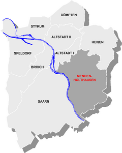
Menden-Holthausen is a district of the independent North Rhine-Westphalian city of Mülheim an der Ruhr . In addition to Menden and Holthausen, the districts of Ickten and Raadt also belong to it . Menden-Holthausen is strongly characterized by agriculture.
location
The most populous district of Mülheim is in the Rechtsruhr-Süd district. It borders in the north on Altstadt I , in the northeast on Heißen , in the east and south on the Essen districts of Haarzopf , Schuir and Kettwig . To the west, on the other side of the Ruhr , is the Saarn district , which is connected by the Mendener Bridge ( B1 ). In Menden-Holthausen, more precisely on the Raadter Heights at the Essen / Mülheim airfield, the highest point in the Mülheim urban area is 152.7 m above sea level .
history
Menden was named as Menethinna in a register of Werden Abbey for the first time on October 27, 811 , when Abbot Hildegrim acquired six acres of land here. Menden and Holthausen belonged to the Broich rule in the late Middle Ages and in the early modern period . Up until the beginning of the 20th century, there were three independent communities in the area of what is now the district:
- The municipality of Holthausen had an area of 4.9 km². Its population in 1895 was 2,566. Holthausen was incorporated into the city of Mülheim an der Ruhr in 1904.
- The municipality of Menden had an area of 6.0 km². Its population in 1910 was 787. After the dissolution of the Mülheim an der Ruhr district in 1910, Menden was temporarily part of the Essen district and in 1920 was incorporated into the city of Mülheim an der Ruhr.
- The municipality of Raadt had an area of 2.2 km². Its population in 1910 was 260. After the dissolution of the Mülheim an der Ruhr district in 1910, Raadt was temporarily part of the Essen district and in 1920 was incorporated into the city of Mülheim an der Ruhr.
Attractions
The Essen / Mülheim airfield is located on the city limits to Essen . The Ruhrtalbrücke Mülheim spans the Ruhrtal from the Raadter Heights to the Auberg as part of the federal highway 52 . Above the Ruhr valley, the Bismarck tower and the Urge house were built on the heights of the Kahlenberg . The building, which was used as the Mülheim youth hostel until 2010 , is located below these cultural monuments, directly on the banks of the Ruhr. It opened in 1890 (the foundation stone was laid in 1889) as a restaurant on Kahlenberg and was converted into a youth hostel in 1952. The youth hostel has been closed since the end of 2010 and eight luxury apartments with a direct view of the Ruhr are to be built in the listed building.
Other buildings that are classified as cultural monuments due to their structural or historical importance are listed in the list of architectural monuments in Menden-Holthausen .
traffic
Holthausen is connected to the old town by two tram routes (104, 112) . These end at the main cemetery, where there is a break point to the 130 bus line that begins there to Essen-Haarzopf and the Rhein-Ruhr-Zentrum . Menden is only accessible via bus route 151 which connects Mülheim-Zentrum and Essen-Kettwig . Then the Tangentiale bus line 753 of the Rheinbahn runs in Menden-Holthausen , which crosses the trams at Oppspring and the 151 at the Mendener Bridge and runs from the main station through the Rumbachtal to Saarn and Ratingen Mitte .
Menden-Holthausen is connected to the federal trunk road network via the Essen-Kettwig motorway junction of federal motorway 52 near the Essen / Mülheim airfield.
Green spaces
The Witthausbusch is the largest public park in the city of Mülheim an der Ruhr. The Mülheim main cemetery with its listed portal is located on Zeppelinstrasse . The Holthausen cemetery is much smaller, but worth seeing because of some old graves .
literature
- Andreas ter Brink: Menden in Mülheim an der Ruhr. 1200 years of history . 2017.
Web links
Individual evidence
- ↑ Population on December 31, 2017. December 31, 2017 .
- ^ Community encyclopedia for the Kingdom of Prussia 1885
- ↑ gemeindeververzeichnis.de: District of Mülheim an der Ruhr
- ↑ Timeline of Mülheim's history. Kulturbetrieb Mülheim an der Ruhr, accessed on March 7, 2012 .
- ↑ Youth hostel in Mülheim gives way to luxury apartments. DerWesten.de, December 16, 2010, accessed on March 7, 2012 .
Coordinates: 51 ° 24 ' N , 6 ° 55' E


