
Mont-Saint-Michel and its bay
| Mont-Saint-Michel and its bay | |
|---|---|
|
UNESCO world heritage |
|

|
|
| View of Mont-Saint-Michel from the surrounding salt marshes |
|
| National territory: |
|
| Type: | Culture |
| Criteria : | (i) (iii) (vi) |
| Surface: | 6,560 ha |
| Buffer zone: | 191,858 ha |
| Reference No .: | 80th |
| UNESCO region : | Europe and North America |
| History of enrollment | |
| Enrollment: | 1979 ( session 3 ) |
| Extension: | 2007, 2018 |
Mont-Saint-Michel and its bay is one of the UNESCO -listed site of World Heritage in France . It includes the rocky island of Mont Saint-Michel with the abbey of the same name and the surrounding bay in the English Channel off the coast of Normandy . The Moidrey mill (19th century) on the mainland has also been a World Heritage Site since 2007 .
history
The island was originally called Mont-Tombe , but became known as Mont-Saint-Michel in the 8th century when the Bishop of Avranches built a Chapel of St. Michael, which became one of the most visited pilgrimage sites in France. In 966 the Duke of Normandy Richard I founded a Benedictine abbey in its place. This was partially burned down in 1203 when King Philip II of France tried to take the mountain. He compensated the monks by paying for the construction of the monastery known as La Merveille ("The Miracle").

In 1254 the island became a royal fortress and withstood sieges during the Hundred Years War (1337-1453) and the French Huguenot Wars (1562-1598). In the 18th century the monastery fell into disrepair, and when it was disbanded during the French Revolution , only seven monks remained there. Under Napoleon I it was used as a penal institution until 1863 , after which it was listed as a historical monument and restored in 1874 .
description

The island of Mont-Saint-Michel is almost circular (about 900 meters in circumference) and consists of a granite rock that rises steeply up to 78 meters from the bay of Mont-Saint-Michel. Most of the time it is surrounded by extensive sandbanks and only becomes an island when the tides are very high . Before the construction of the approximately 2 km long road dam that connected the island to the mainland, it was particularly difficult to reach because of the quicksand and the very rapidly rising tides. However, the dam has become an obstacle to the evacuation of sediments , which has resulted in higher sandbars between the island and the coast.
The abbey church , which overlooks the island, has an imposing Romanesque nave from the 11th and 12th centuries and a late Gothic choir in the flamboyant style . The tower and the spire , crowned by a statue of St. Michael , were added in the 19th century. The church rests on three crypts , the oldest of which probably dates from the Carolingian period . The three-storey monastery La Merveille , built in 1228, includes the four-aisled knight's hall, the large refectory with its tall, narrow windows and the cloister with five colonnades open to one side of the sea .
From the medieval walls from the 13th to 15th centuries on the south and east side of the mountain there is a panoramic view of the bay. Some of the houses along the narrow street that leads up to the abbey date from the 15th century.

Abbey church

refectory

Knight hall
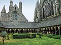
Cloister

Village below the monastery


Registration as a world heritage site
In 1979, Mont-Saint-Michel and its bay were inscribed on the UNESCO World Heritage List as a World Heritage Site in France, following a decision of the third session of the World Heritage Committee.
The World Heritage Site covers an area of 6,560 hectares with a buffer zone of 191,858 hectares.
The reason for the entry states, among other things:
The Mont-Saint-Michel, a sanctuary located in a difficult-to-reach place and in keeping with the tradition of the places of worship dedicated to Saint Michael, a pilgrimage site frequently visited throughout the Middle Ages and later the seat of a Benedictine abbey with a strong intellectual influence, is in its characteristic aspects one of the most important places of Christian civilization in the Middle Ages.
The entry was made on the basis of criteria (i), (iii) and (vi).
(i): Due to the unique combination of natural surroundings and architecture, the Mont-Saint-Michel represents a unique aesthetic success.
(iii): Mont-Saint-Michel is an incomparable ensemble, both because of the juxtaposition of the abbey and the fortified village within the narrow confines of a small island and because of the originality of the arrangement of the buildings, which correspond to its unforgettable silhouette.
(vi): The Mont Saint-Michel is one of the most important sites of medieval Christian civilization.
integrity
The restorations of the 19th century gave the buildings their value and their symbolic aspect back, especially with the construction of the spire in 1897. Despite the silting of the bay, the value of the site was increased by natural phenomena and above all by the construction of an access dam in 1879 preserved, whereby the Mont lost its insular character. After the extensive work by the French state was completed in 2015, the maritime character of Mont Saint-Michel was restored.
authenticity

The relationship between the Mont and the vast surrounding bay has remained intact for centuries. The buildings of the abbey and the surrounding village, which have been appropriately maintained, restored or renewed since the 17th century, are of remarkable authenticity in their substance, development or arrangement . The abbey, which was dissolved in 1789 and converted into a prison until 1863, is now a monument that bears witness to the Christian past. Monastic life is guaranteed by a small community. The visual characteristics of the Mont, with its topography and its status as a highly visible landmark related, are very susceptible to interference with the landscape that could change the landscape and from the site. There is also the risk that the high number of visitors (3 million tourists per year) will affect the character of the place.
Hazards and protective measures
The natural and architectural ensemble is protected at national level either under the Monument Protection Act or the Environmental Act. The abbey, its fortress walls and outbuildings belong to the state and have been a listed building since 1862. The coastline, which is a World Heritage Site, is protected by coastal law, and the bay has been protected by the Ramsar Convention since 1994 .
The state has entrusted the management of the abbey to the National Center for Monuments, an institution under the Ministry of Culture. It benefits from important and regular restoration work. Consolidation work on the rocks is carried out periodically, taking into account the geological nature of the site.

Since the restoration of the maritime character of Mont-Saint-Michel, the dam has been replaced by a footbridge and a shuttle service ensures the transport of visitors from the town of La Caserne to the foot of the Mont. The establishment of this infrastructure has made it possible to regulate the flow of tourists. Hydraulic structures such as the dam of Couesnon where the waters, the sediments rinses off the coast, also combat the silting of Mont.
The buffer zone proposed in 2018 includes almost 130 municipalities. Its limit was determined on the basis of a landscape study and is based on the visibility of Mont-Saint-Michel, the main panoramas and the so-called montjoies .
Web links
- Entry on the UNESCO World Heritage Center website ( English and French ).
- Nomination file (English, French)
Individual evidence
- ↑ Moulin de Moidrey. Pays de la Baie du Mont-Saint-Michel, archived from the original on December 12, 2019 ; accessed on May 28, 2020 (French).
- ↑ Decision: CONF 003 XII.46 - Consideration of Nominations to the World Heritage List. UNESCO World Heritage Center, 1979, accessed May 28, 2020 .
- ↑ a b c d e f g h i Entry on the website of the UNESCO World Heritage Center ( English and French ).
- ↑ Viewpoints up to 42 km away, from which the Mont is just visible. These points were already known to pilgrims in the Middle Ages. Le Mont Saint-Michel , www.cndp.fr

Historic city centers:
Episcopal city of Albi (2010) |
Roman and Romanesque Monuments of Arles (1981) |
Papal Palace , Cathedral and Avignon Bridge (1995) |
Bordeaux , Port de la Lune (2007) |
Carcassonne (1997) |
Le Havre (2005) |
Lyon (1998) |
Stanislas, de la Carrière and d'Alliance squares in Nancy (1983) |
Seine River from Paris (1991) |
Provins , city of medieval fairs (2001) |
Strasbourg: from Grande-Île to New Town (1988, 2017) |
Vézelay abbey church and hill (1979)
Structures: Fontenay Abbey (1981) | Saint-Savin Abbey (1983) | Belfries in Belgium and France (2005) | Canal du Midi (1996) | The architectural work of Le Corbusier (2016) | Vauban's fortifications (2008) | Great Saltworks of Salins-les-Bains and Royal Saltworks of Arc-et-Senans (1982) | Amiens Cathedral (1981) | Bourges Cathedral (1992) | Chartres Cathedral (1979) | Mont-Saint-Michel and its bay (1979) | Pont du Gard (1985) | Notre Dame Cathedral, former Saint-Remi Abbey and Palais du Tau in Reims (1991) | Fontainebleau Castle and its Park (1981) | Palace and Park of Versailles (1979) | Orange Theater and Arc de Triomphe (1981)
Archaeological sites:
Chauvet grotto near Vallon-Pont-d'Arc (2014) |
Prehistoric pile dwellings around the Alps (2011) |
Vézère valley: sites and cave paintings (1979)
Cultural and natural landscapes: Nord-Pas de Calais mining area (2012, K) | District Saint-Emilion (1999 K) | Causses and Cevennes (2011, K) | Climats - vineyards in Burgundy (2015, K) | French Southern and Antarctic Lands (2019, N) | Way of the pilgrims in France (1998, K) | Gulf of Porto: Piana Calanche, Gulf of Girolata and Scandola Nature Reserve (1983, N) | Mont Perdu (1997, K / N) | New Caledonia lagoons (2008, N) | Loire Valley - Between Sully-sur-Loire and Chalonnes-sur-Loire (2000, K) | Taputapuātea (2017, K) | Volcanic landscape on La Réunion (2010, N) | Vineyards, wine houses and wine cellars of Champagne (2015, K)
Coordinates: 48 ° 38 ′ 10 " N , 1 ° 30 ′ 40" W.