Prümzurlay
| coat of arms | Germany map | |
|---|---|---|

|
Coordinates: 49 ° 52 ' N , 6 ° 26' E |
|
| Basic data | ||
| State : | Rhineland-Palatinate | |
| County : | Eifel district Bitburg-Prüm | |
| Association municipality : | South Eifel | |
| Height : | 181 m above sea level NHN | |
| Area : | 3.88 km 2 | |
| Residents: | 572 (Dec. 31, 2019) | |
| Population density : | 147 inhabitants per km 2 | |
| Postal code : | 54668 | |
| Area code : | 06523 | |
| License plate : | BIT, PRÜ | |
| Community key : | 07 2 32 108 | |
| LOCODE : | DE PR8 | |
| Association administration address: | Pestalozzistraße 7 54673 Neuerburg |
|
| Website : | ||
| Local Mayor : | Alfred bubbles | |
| Location of the local community of Prümzurlay in the Eifel district of Bitburg-Prüm | ||
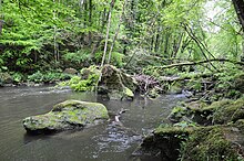
Prümzurlay is a state-approved resort in the Eifel district of Bitburg-Prüm in Rhineland-Palatinate and part of the German-Luxembourgish South Eifel nature park . The local community belongs to the Verbandsgemeinde Südeifel . The place is known for the Prüm waterfalls between Prümzurlay and Irrel and the up to 50 m high Lias sandstone rock formations on the edge of the narrow valley. The first bungalow holiday village in Germany was built near the ruins of the Prümerburg in 1960, today's district of Prümerburg.
history
In 798/802 AD, today's town of Prümzurlay was first mentioned as "Prumia" in a deed of donation from Echternach Abbey . Settlements in the same place have probably existed for much longer. Evidence of this can be found in the remains of a Roman villa in the Mausebach district as well as in the prehistoric and later presumed fortifications of the Celts ( Treveri ) in the Prümerburg district .
The history of the place Prümzurlay is closely connected with the Prümerburg. Prümzurlay is characterized by a very narrow valley location. The Prümerburg, located on a 40 m high sandstone cliff, towers over the entire valley and offers an optimal overview. It is believed that the first inhabitants of the place were dependent on the lords of the castle, but this is not historically proven.
Very little is known about the early Middle Ages. It was not until 1658 that records of “Prum zur Layen” were found again. It shows the consequences of the Dutch-French War ( sic ): there is only one male living in the village.
Around 1810, a large landslide in the Münsterwald was completely buried. The Prüm jams. As the local chronicle reports, there was great fear in the population at the time that a lake could form and Prümzurlay would sink. It can be assumed that the Prüm waterfalls (today often called “Irreler waterfalls”), which can be found in this area, took on their present form at that time.
District of Prümerburg
The cottage settlement “Feriendorf Prümerburg” was built in 1960 near the ruins of the “Prümerburg” castle. 148 holiday homes were built on a total area of around 180,000 square meters. It was the first settlement of this kind in the Federal Republic.
Origin of the place name
The name “Prümzurlay” was coined by the river “Prüm” flowing through the town and the Moselle Franconian word “Layen”. The term "Layen", or in the singular " Lay ", describes the impressive sandstone shapes in the vicinity of Prümzurlay. The best known is the Teufelsschlucht (Eifel) , about 3 km from Prümzurlay. The name of the place has changed in many ways over the course of history. Prümzurlay always belonged to a border region and often changed rulers (Luxembourgish, French) until it was finally added to Prussia in 1815. This is reflected in the place name. If Prümzurlay was originally mentioned as "Prumia", this changed to "Proeme zur Leyen" and the French "Prume sur Leyen" until the name took on its current form. On the other hand, there is also a possible and simple linguistic justification for the place name. The old German word lei / ley / lay means rock, which corresponds to the wealth of rocks in the place and its surroundings. The Prüm River flows through the village. It all adds up to: the Prüm river near the rocks, Prüm zur Layen, Prümzurlay.
Population development
The development of the population of the municipality of Prümzurlay; the values from 1871 to 1987 are based on censuses:
|
|
politics
Municipal council
The council in Prümzurlay consists of twelve council members, who in the local elections on May 26, 2019 in a majority vote were elected, and the honorary mayor as chairman.
coat of arms
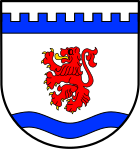
| Blazon : "In silver a gold-tongued and gold-armored rising red lion, in the head of the shield a blue, pinned bar above, in the base of the shield a blue wave bar." | |
Coats of arms:
|
traffic
The place is crossed by the state road 4 running parallel to the Prüm . This crosses Kreisstraße 21 in the center of the village . Parts of both streets belong to the Land & Kultur Route Eifel in the Prümzurlay district.
Personalities from the place
- Petrus Borne (1910–1976), Benedictine monk, Abbot of Tholey, Abbot President of the Beuron Congregation
See also
literature
- Ernst Wackenroder : The art monuments of the Saarburg district . (= Paul Clemen (Hrsg.): Die Kunstdenkmäler der Rheinprovinz , Volume 12 / I. Department). L. Schwann, Düsseldorf 1927 (reprint of the Academic Bookshop Interbook, Trier 1983, ISBN 3-88915-006-3 ), pp. 234-238.
Web links
- To search for cultural assets of the local community of Prümzurlay in the database of cultural assets in the Trier region .
Individual evidence
- ↑ State Statistical Office of Rhineland-Palatinate - population status 2019, districts, communities, association communities ( help on this ).
- ^ The conflict known today as the Dutch-French War was not in 1658, but rather 20 years later. However, this is stated in the local chronicle of 1870. Probably not 1658 but 1678 is meant.
- ^ Chronicle of an Eifel village - 1200 years of Prümzurlay. School and local history of Prümzurlay, records of the school chronicle around 1870. Prümzurlay 1998, p. 53 ff.
- ^ Trierischer Volksfreund , edition of June 3, 1960
- ↑ State Statistical Office Rhineland-Palatinate - regional data
- ^ The Regional Returning Officer Rhineland-Palatinate: Local elections 2019, city and municipal council elections
- ^ Chronicle of an Eifel village - 1200 years of Prümzurlay. Prümzurlay 1998, p. 4.
- ↑ Country & Culture Route


