Rötzenberg
| Rötzenberg | ||
|---|---|---|
| height | 459.1 m above sea level NHN | |
| location | near Gossersweiler ; District of Südliche Weinstrasse , Rhineland-Palatinate ( Germany ) | |
| Mountains | Wasgau ( Palatinate Forest ) | |
| Coordinates | 49 ° 9 '34 " N , 7 ° 54' 41" E | |
|
|
||
| Type | Kegelberg | |
| rock | Buntsandstein and Zechstein rock units | |
| Age of the rock | 251–243 million years (red sandstone) , 256–251 million years (Zechstein) |
|
| particularities | Bizarre rock formations; Rötzenfelsen: panoramic view, breeding ground for peregrine falcons | |
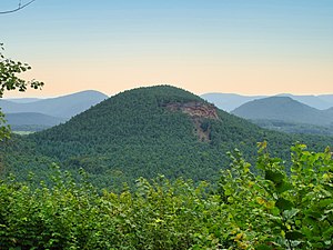
The Rötzenberg near Gossersweiler in the Rhineland-Palatinate district of Südliche Weinstrasse is 459.1 m above sea level. NHN high mountain in the northern Wasgau in the Palatinate Forest . There are numerous rock formations of the Buntsandstein .
Geographical location
The Rötzenberg is located in the Palatinate Forest Nature Park as a typical cone mountain for the Wasgau in the northern part of the Dahner Felsenland and in the Wasgauer Felsenland. Its summit rises 1.1 km to the west-southwest of Gossersweiler , the larger district of the municipality of Gossersweiler-Stein , to which the mountain belongs. The Triebborn rises to the north of the almost completely wooded mountain, which drains over the Rimbach into the Rhine tributary Queich , and to the south the Klingbach , which flows directly into the Rhine plain and flows into the Rhine over the Michelsbach .
Rocks and views
The most important rocks of the Rötzenberg are the Isselmannsteine on the north side and the imposing Rötzenfels south of the summit, which reaches a considerable rock height of up to 55 meters. From the rock plateau, which can be climbed on a hiking trail (Dimbacher Buntsandstein-Höhenweg) with appropriate caution, you have an excellent view to the south over the entire Wasgau with the Lindelbrunn ruins in the foreground and to the northeast to the Rehberg , the Ebersberg , the Asselstein and the Trifels Imperial Castle .
Access and walks
The Rötzenberg can be reached via marked hiking trails from the east from Gossersweiler, from the north from Dimbach and from the south from Lindelbrunn . It is crossed by the “Rimbach-Steig” and “Dimbacher Buntsandstein-Höhenweg” circular hiking trails, which were certified as premium trails by the German Hiking Institute and inaugurated in 2013.
Picture gallery
Web links
Individual evidence
- ↑ a b Rötzenberg. Topographic map. In: LANIS. naturschutz.rlp.de, accessed on January 23, 2017 .
- ↑ Palatinate hiking menu: Rimbach-Steig . Retrieved October 10, 2017
- ↑ Palatinate hiking menu: Dimbacher Buntsandstein-Höhenweg . Retrieved October 10, 2017


