Rabengrund of Wiesbaden
|
Rabengrund of Wiesbaden
|
||
|
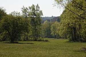
Meadows in the Rabengrund |
||
| location | north of Wiesbaden in the Taunus | |
| surface | 79.05 hectares | |
| Identifier | 1414002 | |
| WDPA ID | 165071 | |
| Geographical location | 50 ° 7 ' N , 8 ° 13' E | |
|
|
||
| Sea level | from 210 m to 300 m | |
| Setup date | March 22, 1988 | |
The Rabengrund of Wiesbaden is a local recreation area , nature reserve and FFH area in Wiesbaden in the German state of Hesse .
geography
The protected area is located in the northeast district , but belongs to the Sonnenberg district . To the north is the plate with the hunting lodge of the same name ( 501 m ) and the defunct Würzburg ramparts . To the southeast is the Bahnholzer Kopf ( 288 m ), to the south Leichtweißhöhle , Neroberg and Nordfriedhof , to the west the valley of the Kesselbach and to the northwest the Wehener Wand ( 494 m ). The local recreation area close to the city is exposed to high ecological stress from cyclists, riders, model pilots and similar leisure activities.
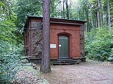
The Adolf-Weygandt-Hütte and the Rettert-Brunnen are located on the north-western edge of the protected area, just above the Amtmannborn. In the northeastern part of the Köglerweg named after Kaspar Kögler lies the Habelsquelle, the origin of the Schwarzbach . In the meantime it was planned that this source would feed the water ballast runway of the Nerobergbahn . There is a pond just below the protected area , after which the stream flows through the landscape park of the upper Nero valley towards Wiesbaden city center and over the Salzbach in Biebrich into the Rhine .
The Rabengrund lies in the water protection area , as the listed Münzberg tunnel , which was completed in 1890, taps groundwater from the Taunus quartzite for the Wiesbaden drinking water supply. Its mouth hole is west of the Rabengrund on the Himmelswiese ⊙ . The springs at the Rabengrund were already used for drinking water at the time of the Roman settlement Aquae Mattiacorum , and there was a villa rustica nearby . The large Kisselborn, located north below the slab , was captured in 1821/22 on the initiative of the then urban planner Christian Zais and laid as a drinking water pipe to Wiesbaden.
The mean temperature in the Rabengrund is around 10 ° C, the mean annual precipitation 600–650 mm.
natural reserve
The 79.05 hectare nature reserve was designated on March 22, 1988 in the natural area of the Rheingau-Wiesbadener Vortaunus (part of the Vortaunus ) and the Wiesbadener Hochtaunus (part of the High Taunus ) according to the Hessian Nature Conservation Act. Together with areas north of this protected area, an 83.76 hectare FFH area “Rabengrund von Wiesbaden with adjacent areas” was designated in May 2000 , which belongs to the Natura 2000 network and is completely surrounded by the FFH area beech forests north of Wiesbaden . The Rabengrund is located within the Rhein-Taunus Nature Park and Zone I of the Wiesbaden City Landscape Protection Area .
The partially wooded meadow lowlands go back to extensive agricultural use in Roman times . The purpose of nature conservation is to secure and preserve the rare plant communities of earlier cultivated landscapes that occur in the Rabengrund and an adjacent Waldwiesenbachtal through extensive forms of cultivation as a habitat for rare and partially threatened animal and plant species. There are acidic semi-dry lawns , lean and warm oat meadows , pipe grass meadows , beech forest and reed beds . In addition, orchids such as broad-leaved orchids , small orchids , fire orchids and two-leaved forest hyacinths can be found, the green hollow tongue has its only location here in the Taunus. More than 100 specimens of the autumn rootwort were still available in 1985, the last flowering and fruiting plants were observed in 2001, they are considered extinct here. A species of butterfly that is worth protecting is the dark blue ant blue .
The biotope complex "Grassland-hornbeam forest-humid wood complex in Rabengrund north of Wiesbaden", which has been protected since 1996 and contains several individual biotopes, is located within the nature reserve.
A geological circular route has been set up around the Rabengrund. The protected area is looked after by the Forsthaus Chausseehaus von Hessen-Forst .
See also
Web links
Individual evidence
- ↑ a b c Ordinance on the "Rabengrund von Wiesbaden" nature reserve of March 22, 1988 . In: State Gazette for the State of Hesse , No. 14, pp. 756–758.
- ↑ City map of the state capital Wiesbaden, select administration > local districts . Retrieved May 2, 2020.
- ↑ a b c d nature reserves , website of the city of Wiesbaden. Retrieved May 2, 2020.
- ^ Upper Nerotal Landscape Park , website of the city of Wiesbaden. Retrieved May 2, 2020.
- ^ A b Eberhard Kümmerle, Benedikt Toussaint, Helmut Arnold, Gudrun Radtke: Geological circular route in the Rabengrund . In: Yearbooks of the Nassau Association for Natural History 135, Wiesbaden 2014, ISSN 0368-1254 , pp. 63–84.
- ↑ Wolfgang Merkel: Gas, water and electricity - from the history of the Wiesbaden municipal utility . August 23, 2005.
- ↑ a b c d Wolfgang Ehmke : The orchids in the Hessian West Taunus , In: Geobot. Kolloq. 18, Frankfurt am Main, March 2005, ISSN 0940-6581 , p. 11.
- ↑ Martin Lauth: On the origins of the Nassau water supply for the city of Wiesbaden . In: Yearbooks of the Nassau Association for Natural History 134, Wiesbaden 2013, pp. 117–136.
- ↑ a b Berthold Hilgendorf, Matthias Fehlow: Basic data acquisition for the FFH area 5815-301 "Rabengrund of Wiesbaden with adjacent areas" , October 2005.
- ↑ Geographical Land Survey 1: 200,000 - Natural Spatial Structure of Germany, sheet 138 , 1971.
- ↑ a b Profiles of the Natura 2000 areas: 5815-301 Rabengrund of Wiesbaden with adjacent areas (FFH area) . Federal Agency for Nature Conservation , accessed on May 2, 2020.
- ↑ Regional Council Darmstadt (ed.): Action plan for the FFH and nature reserve "Rabengrund of Wiesbaden with adjacent areas" , July 8, 2008.
- ^ Rabengrund from Wiesbaden with adjacent areas in Germany , www.protectedplanet.net, accessed on May 2, 2020.
- ↑ Beech forests north of Wiesbaden in Germany , www.protectedplanet.net, accessed on May 2, 2020.
- ↑ Overview map of the landscape protection area "City of Wiesbaden" . Retrieved May 2, 2020.
- ↑ Natureg Viewer , Hessian State Office for Nature Conservation, Environment and Geology , see Protected Areas . Retrieved May 2, 2020.
- ↑ Overview of the local area management - nature reserves , status: July 15, 2013.


