
Plauen Castle

Plauen Castle , also known as the Castle of the Vögte, is a castle complex in the Schlossberg district of Plauen that has only survived in ruins .
The hilltop castle was built around 1250 as the seat of the bailiffs of Plauen . From 1466 it served as the Electoral Saxon official seat, burned down in 1548, was rebuilt around 1670 as a secondary residence of Saxony-Zeitz , served again after 1718 as the Electoral Saxon official and court seat and from 1852 as a prison.
In April 1945, the large area was significantly destroyed by air raids, along with large parts of the old town. Cell tracts that were preserved continued to serve as a correctional facility after the war and were only demolished in 2013. An archaeological excavation followed. In the future, the campus of the Plauen State Academic Academy will be housed in new buildings on the site , with the ruinous historical structure being preserved and partially rebuilt.
history

Plauen was founded by the Counts of Everstein (or Eberstein) from southern Lower Saxony, who from around 1100 brought settlers to the Dobnagau for clearing and reclamation . The first fortified seat of the Eversteiners was on the Dobenaufelsen in the nearby Syratal , later they built a city castle on the southwest corner of the Plauen wall ring, the remnant of which is today's Malzhaus. This city castle was mentioned for the first time in 1224, but it was probably built about a century earlier, at the time when Adalbert von Eberstein donated the Johanniskirche in 1122 .
Probably the Dobnagau including the Plauen settlement fell after the extinction of the first generations of the Eversteiners on their main line in the Weser Uplands. They considered it right to use energetic and assertive ministerials to manage them . The neighboring bailiffs of Weida , who had already founded various places in the Vogtland , which is named after them, offered themselves. Therefore was probably already Henry II. "The rich," Vogt of Weida , Gera and Greiz († around 1209), the Ever Steinern with Plauen belehnt Service. His second son, Heinrich IV., The middle one († 1249/1250), had held the title of Vogt of Gera and Plauen from 1237. When the territory of the bailiffs was divided around 1244, the three independent bailiwicks of Weida, Gera and Plauen were finally created. The son of the aforementioned, Heinrich I von Plauen († around 1303), received Plauen, his brother of the same name founded the line of bailiffs of Gera , while a cousin continued the bailiffs of Weida.

It was probably Heinrich I who, in topographical opposition to the town castle of the Eversteiners, built a new castle on a spur that overlooked everything, the castle of the bailiffs, from which the stone bridge over the Weisse Elster at the foot of the castle hill could be monitored, first mentioned in 1244. Heinrich I married a Countess von Everstein and in 1278 received the town of Plauen and the Gau Dobena from his brother-in-law Konrad von Everstein. His older son Heinrich II , "the Bohemian", founded the line of the bailiffs of Plauen , the younger, Heinrich Ruthenus , "the Russian", the younger line, the later Princely House of Reuss .
In the 14th century, however, the bailiffs fell victim to the expansive efforts of their neighbors, the margraves of Meissen and the kings of Bohemia: the bailiwicks made alliances with the two neighbors, some of which were aimed at each other, so in 1327 the house of Plauen came under Bohemian suzerainty, while the governors of Weida and Gera joined the Wettins . In the Vogtland War from 1354 to 1357, the bailiffs of Weida, Gera and Plauen lost most of their property to Emperor Charles IV and the Wettins. Charles IV declared the rule of Plauen to be a hereditary fief of his Bohemian kingdom in 1356 . In 1466, with the expulsion of the tyrannical Heinrich II, the rule of the Plauen bailiffs over the offices of Plauen and Voigtsberg , which the Saxon Elector Ernst received as a Bohemian fief, ended. Henry III. von Plauen finally renounced his claims to Plauen in favor of the Wettins in 1482 through the contracts of Brüx . These installed officials at the castle.
In 1430 the Hussites besieged the city under the leadership of Andreas Prokop . They took the castle and destroyed it. In 1547, King Ferdinand of Bohemia enfeoffed the grandson of the once expelled Heinrich II again with the town and rule of Plauen. Since then he has been allowed to call himself Burgrave Heinrich IV . In 1548 he was appointed imperial prince at the Augsburg Reichstag . After the death of Henry IV, his sons Henry V and Henry VI pledged . ownership to Elector August von Sachsen , who finally acquired the area in 1563.
In 1632 Field Marshal Holk took Plauen in the Thirty Years War . Although the city surrendered, it was sacked. On September 12th General Gallas followed and on October 12th of the same year Wallenstein arrived with the main army in Plauen, after whose departure the city was set on fire. However, the castle only fell victim to a fire in 1648 and was almost completely destroyed in the process.
In 1656, after the death of Elector Johann Georg I , his fourth son, Duke Moritz von Sachsen-Zeitz, received the town of Plauen and parts of the Vogtland. From 1670 to 1675 he had the castle rebuilt as his second residence. After the Saxon-Zeitz line expired in 1718, the castle was used again as an official and court seat and redesigned for work, living and economic purposes.
Building description and uncovered ruins

Red Tower
Red tower (left), in the background the towers of the Johanniskirche
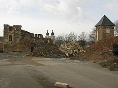
North tower (right)

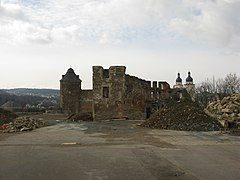
Ruin of the transept (16th / 17th century)


Only the excavation carried out after the prison cell wing was demolished in March 2014 provided more information about the original shape of the hilltop castle . After that, the partially preserved wall ring had a triangular floor plan from the start. At the southern tip of the triangle there is still the striking fourteen-cornered Red Tower with a view of the city and the Elster Bridge; the square north tower also stands on the northern tip to this day. The eastern point was dominated by the no longer existing White Tower, which was mentioned until the middle of the 17th century.
None of the towers comes from the early days of the complex. One of the oldest findings, however, is a filled neck ditch in front of the north tower, which cut off the mountain spur from the plateau behind. It is still unclear where the original inner castle was. According to an older view (Bachmann), this should have stood in the upper courtyard. The underlying assumption of a ditch in front of the transept and a keep in the upper courtyard could be refuted by the excavations. The onshore situation speaks (according to Wickes) against a core castle at this point.
Between the north tower and the ditch mentioned were the foundation walls of a permanent house , probably from the 13th century, and along the western slope edge in the direction of the Red Tower the foundation walls of five cellars and another, younger residential tower , probably from the 14th or 15th century Th century; A lime kiln also dates from this period. In addition, a well over 21 m deep was uncovered.
The medieval buildings were removed during later construction work and the soil layers in the southern castle grounds were removed, presumably to create a level courtyard area in the 1670s. This makes the older construction phases difficult to reconstruct. A layer of fire indicates the Hussite storm of 1430, to which parts of the castle fell victim. The red tower can be dendrochronologically dated to the time around 1425, when Henry X was already fighting against the Hussites.
Sources from the 15th century mention - in addition to the three towers - the following buildings: a large bower with various rooms (princely parlor, court parlor, women's parlor, nursery, small parlor, bath room), church, cannery, brewery, bakery, kitchen, horse stables, sheep house , Chicken house, pipe water and fish box as well as a grain house, which was significantly expanded around 1500, with a length of 40 m and at least three floors.
During the reconstruction after the Hussite storm, a large, representative new building (the "west wing") was erected in the north-west of the complex - including the two original fixed houses - with at least 42 m length and 10 m width and gables of different heights on the city side , like him a picture by Wilhelm Dilich from 1626–1629 can be seen on which all roofs are missing. Because in 1548 the ensemble, which had now been converted into a renaissance castle, was burned out and only reappeared in the sources 120 years later.
The west wing, the granary and other castle buildings were repaired. Above all, however, a new transept was built, the ruins of which are still preserved. It was inaugurated in 1675 and divides the complex into a north-western upper and a south-eastern lower courtyard. The structure of the construction phases and the language of form indicate that construction began as early as the 16th century. After a phase of unknown length, the building, originally designed as a renaissance building, was completed as an early baroque structure. As a builder comes Moritz Richter d. J. (1647-1705). The west wall of the new building was led with an arch over the clear well shaft so that it could be used from the windows. Basement rooms have been preserved under the building, including a tunnel driven through the rock to the well. In the 19th century the west wing was partially replaced by a new building.
The facility suffered severe damage in April 1945 when it was destroyed, along with large parts of the old town, in several air raids. Except for the two towers, parts of the outer wall and the outer walls of the transept (the south facade is preserved almost up to the eaves edge, of the north facade only part of the arcade is left), all buildings were destroyed. Cell tracts that have been preserved in the north-eastern hinterland of the castle continued to serve as a correctional facility until 2007 after the war and were only demolished in 2013 together with the high prison wall. The slope retaining wall was temporarily stabilized and the kennel was partially dredged. The entire site has been redeveloped since 2014, and initial reconstruction concepts are already in place for the transept.
Individual evidence
- ↑ The excavation results are being carried out as part of a doctoral project at the chair of Prof. Dr. Ulrich Müller at the Christian-Albrechts-Universität zu Kiel , with funding from the State of Saxony and support from the State Office for Archeology of Saxony .
literature
- Jörg Wicke: Castle and castle of the bailiffs in Plauen. In: Burgen und Schlösser , magazine for castle research and monument preservation , 57th year 2016, issue 4, pages 205–215.
- (The Malzhaus in) Plauen, In: Dr. Helmuth Gröger: Castles and palaces in Saxony, Heimatwerk Sachsen, 1940, pp. 36–37
Web links
Coordinates: 50 ° 29 ′ 42.1 ″ N , 12 ° 8 ′ 24.4 ″ E