
Schlossrued
| Schlossrued | |
|---|---|
 |
|
| State : |
|
| Canton : |
|
| District : | Kulm |
| BFS no. : | 4142 |
| Postal code : | 5044 |
| Coordinates : | 649 201 / 237960 |
| Height : | 498 m above sea level M. |
| Height range : | 472–681 m above sea level M. |
| Area : | 7.25 km² |
| Residents: | 837 (December 31, 2019) |
| Population density : | 115 inhabitants per km² |
|
Proportion of foreigners : (residents without citizenship ) |
9.1% (December 31, 2019) |
| Website: | www.schlossrued.ch |
 Schlossrued with lock |
|
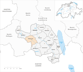
| Location of the municipality | |
  |
|
Schlossrued ( Swiss German : ˈʃlɔsːˌruəd ) is a municipality in the Swiss canton of Aargau . It belongs to the Kulm district and is located in the lower Ruedertal .
geography
The community lies in the lower part of the Ruedertal, which is traversed by the Ruederche and bordered on both sides by chains of hills. The valley floor is only 50 meters wide in the upper part and widens to a width of around 250 meters in the lower part. The north-eastern side of the valley is very fragmented and has numerous short side valleys with the foothills of the Galgenmoos ( 654 m above sea level ) and the Samlen ( 643 m above sea level ) in between; these hills form the border with the Wynental . The south-western side of the valley is more evenly shaped and rises to the castle ( 649 m above sea level ) and to the edge of the Rötler plateau, which demarcate the Ruedertal from the Suhrental . One kilometer southeast of the main settlement of Schlossrued is the village of Kirchrued, where the only church in the entire valley is located. In addition, numerous individual farms are scattered across the entire municipality.
The area of the municipality is 725 hectares , of which 225 hectares are forested and 55 hectares are built over. The highest point is at 680 meters on the edge of the Rötler plateau, the lowest at 475 meters on the Ruederche. Neighboring communities are Schöftland in the northwest, Unterkulm in the north, Oberkulm in the east, Schmiedrued in the southeast, Kirchleerau in the south and Staffelbach in the west.
history
The Ruedertal was settled in the 5th and 6th centuries by the Alemanni , who cleared the dense jungle . In 1160 the "Lords of Ruoda" were mentioned for the first time in the Acta Murensia of the Muri Monastery . The place name is derived from the Old High German (ze) Ruoderahu , which means "near the Ruderbach"; a body of water that can be crossed by rowing. The Lords of Rued were a ministerial family of the Counts of Kyburg , from 1273 of the Habsburgs . They probably gave up their ancestral castle Alt-Rued in the 11th or 12th century and moved to the other side of the valley in Castle Rued .
After the family died out in 1369, there were several changes of ownership: First, the Rued lordship, which in addition to the Ruedertal also included the villages of Kirchleerau and Moosleerau , belonged to the lords of Büttkon, then the barons of Rüssegg and the lords of Scharnachtal. From 1491 it was owned by the Herport family from Willisau, and in 1516 it came back to the Lords of Büttikon. The confederates destroyed the castle in 1386 during the Sempach War , and in 1415 they conquered Aargau. Schlossrued now belonged to the subject area of the city of Bern , the so-called Berner Aargau .
In 1520 the Lords of May, originally from Italy , acquired the rule, eight years later the Bernese introduced the Reformation . In March 1798 the French took Switzerland, ousted the «Gracious Lords» of Bern and proclaimed the Helvetic Republic . Since then, Schlossrued has belonged to the canton of Aargau. It was not until 1834 that the May sold their last remaining rights to the canton, until 1861 they resided in the castle.
In 1816 the Ruedertal was divided into the communities Schlossrued and Schmiedrued . The population found an additional livelihood in cotton weaving until the middle of the 19th century. When this branch of industry went under due to the remoteness of the valley and the lack of hydropower, many residents had to move away. Agriculture shaped the life of the community well into the 20th century .
Attractions


The schlossrued is located on a promontory north of the village Schlossrued. The medieval castle was completely rebuilt at the end of the 18th century after a major fire and converted into a residential palace. The oldest parts of the church in Kirchrued date from the 13th century, around 1500 a choir was added to the rectangular building . From the outside, the building looks like a large chapel.
The Schlossrued adventure trail offers the opportunity to get to know Schlossrued and the Ruedertaler on three different circular hikes. Information boards provide interesting information about the landscape, history, flora and fauna. There are rest areas and lookout points within the routes.
coat of arms
The blazon of the municipal coat of arms reads: "In blue on a green three-mountain, white, red-roofed tower with black gate, raised by two crossed white oars and a six-pointed white star." The undivided municipality of Ruedertal had until 1816 carried the coat of arms of the Lords of Rued, first attested in 1279, an oar crossed by a boatman's spike. On the municipal seal from 1872, the various symbols were arranged in a confusing way. In 1953 these were rearranged after the town council refused to delete a symbol or two.
population
The population developed as follows:
| year | 1764 | 1803 | 1850 | 1900 | 1930 | 1950 | 1960 | 1970 | 1980 | 1990 | 2000 | 2010 |
| Residents | 549 | 878 | 1000 | 719 | 886 | 848 | 805 | 749 | 833 | 867 | 903 | 839 |
On December 31, 2019, 837 people lived in Schlossrued, the proportion of foreigners was 9.1%. In the 2015 census, 61.6% described themselves as Reformed and 12.7% as Roman Catholic ; 25.7% were non-denominational or of other faiths. In the 2000 census, 96.2% stated German as their main language and 0.9% Serbo-Croatian .
Politics and law
The assembly of those entitled to vote, the municipal assembly , exercises legislative power. The executing authority is the five-member municipal council . He is elected by the people in the majority procedure, his term of office is four years. The parish council leads and represents the parish. To this end, it implements the resolutions of the municipal assembly and the tasks assigned to it by the canton. The Kulm District Court is the first instance responsible for legal disputes . Schlossrued belongs to the Friedensrichterkreis IX (Unterkulm).
economy
According to the company structure statistics (STATENT) collected in 2015, Schlossrued has around 340 jobs, including 26% in agriculture, 43% in industry and 31% in the service sector. In addition to agriculture, metal and wood processing are predominant. Many employed people are commuters and work in Schöftland or in the Aarau region .
traffic
Schlossrued is away from the main traffic axes, but is connected to the Suhrental and Wynental by the canton road 330 . The connection to public transport is provided by a post bus line that runs from Schöftland train station to Schmiedrued (district of Schiltwald).
education
The community has a kindergarten and a school house where primary school is taught. All upper levels ( Realschule , Secondary School and District School ) can be attended in Schöftland . The closest grammar schools are the Alte Kantonsschule and the Neue Kantonsschule , both in Aarau .
Personalities
- Andreas Neeser (* 1964), writer
- Friedrich Amadeus Sigmund von May (1801–1883), lawyer, castle owner and author
- Hans Martin Sutermeister (1907–1977), doctor
literature
- Markus Widmer-Dean: Schlossrued. In: Historical Lexicon of Switzerland .
- Hans Walti: Kirchrued. In: Historical Lexicon of Switzerland .
- Michael Stettler : The art monuments of the canton of Aargau . Ed .: Society for Swiss Art History . Volume I: The districts of Aarau, Kulm, Zofingen. Wiese Verlag, Basel 1948, DNB 366495623 .
Web links
Individual evidence
- ↑ Cantonal population statistics 2019. Department of Finance and Resources, Statistics Aargau, March 30, 2020, accessed on April 2, 2019 .
- ↑ Cantonal population statistics 2019. Department of Finance and Resources, Statistics Aargau, March 30, 2020, accessed on April 2, 2019 .
- ↑ a b Beat Zehnder: The community names of the canton of Aargau . In: Historical Society of the Canton of Aargau (Ed.): Argovia . tape 100 . Verlag Sauerländer, Aarau 1991, ISBN 3-7941-3122-3 , p. 380-382 .
- ^ National map of Switzerland, sheet 1109, Swisstopo.
- ↑ Standard area statistics - municipalities according to 4 main areas. Federal Statistical Office , November 26, 2018, accessed on May 27, 2019 .
- ↑ Schlossrueder adventure trail
- ^ Joseph Galliker, Marcel Giger: Municipal coat of arms of the Canton of Aargau . Lehrmittelverlag des Kantons Aargau, book 2004, ISBN 3-906738-07-8 , p. 268 .
- ↑ Population development in the municipalities of the Canton of Aargau since 1850. (Excel) In: Eidg. Volkszählung 2000. Statistics Aargau, 2001, archived from the original on October 8, 2018 ; accessed on May 27, 2019 .
- ↑ Resident population by religious affiliation, 2015. (Excel) In: Population and Households, Community Tables 2015. Statistics Aargau, accessed on May 27, 2019 .
- ↑ Swiss Federal Census 2000: Economic resident population by main language as well as by districts and municipalities. (Excel) Statistics Aargau, archived from the original on August 10, 2018 ; accessed on May 27, 2019 .
- ↑ circles of justice of the peace. Canton of Aargau, accessed on June 21, 2019 .
- ↑ Statistics of the corporate structure (STATENT). (Excel, 157 kB) Statistics Aargau, 2016, accessed on May 27, 2019 .