Schondra
| coat of arms | Germany map | |
|---|---|---|

|
Coordinates: 50 ° 16 ' N , 9 ° 52' E |
|
| Basic data | ||
| State : | Bavaria | |
| Administrative region : | Lower Franconia | |
| County : | Bad Kissingen | |
| Management Community : | Bad Brueckenau | |
| Height : | 432 m above sea level NHN | |
| Area : | 28.62 km 2 | |
| Residents: | 1703 (Dec. 31, 2019) | |
| Population density : | 59 inhabitants per km 2 | |
| Postal code : | 97795 | |
| Area code : | 09747 | |
| License plate : | KG, BRK, HAB | |
| Community key : | 09 6 72 149 | |
| LOCODE : | DE CHO | |
| Market structure: | 9 districts | |
Market administration address : |
Schulstr. 14 97795 Schondra |
|
| Website : | ||
| Mayor : | Bernold Martin ( CSU / Christian Citizens' Block) | |
| Location of the Schondra market in the Bad Kissingen district | ||
Schondra is a market in the Lower Franconian district of Bad Kissingen and a member of the Bad Brückenau administrative community .
geography
Geographical location
The village is located on the southern slope of the Rhön in the Schondra valley , about 22 kilometers northwest of the district town of Bad Kissingen . In the east, the A 7 motorway runs through the municipality.
Community structure
The nine districts are:
|
Surname
etymology
His name Schondra has the same name, the market town by flowing river Schondra , which the Franconian Saale in Gräfendorf flows.
Earlier spellings
Earlier spellings of the place from various historical maps and documents:
|
|
history
Schondra was first mentioned in a document in 812. The place was owned by the Fulda monastery . From the 15th century, Schondra was the seat of a court .
Incorporations
The municipality has existed in its current expansion since May 1, 1978, when the municipalities of Schönderling and Singenrain were incorporated into Schondra as part of the municipal reorganization of Bavaria .
Religions
The population is predominantly Catholic. The Roman Catholic parish of St. Anna Schondra, which belongs to the Hammelburg deanery of the Würzburg diocese, is located on the territory of the political community . In the district of Schönderling there is the branch church St. Josef , in Singenrain the branch church St. Maria von Fatima . There is a chapel in Schildeck.
Population development
- 1961: 1450 inhabitants
- 1970: 1582 inhabitants
- 1987: 1536 inhabitants
- 1991: 1687 inhabitants
- 1995: 1739 inhabitants
- 2005: 1832 inhabitants
- 2010: 1742 inhabitants
- 2015: 1726 inhabitants
- 2016: 1717 inhabitants
politics
Municipal council
After the last local election on March 16, 2014, the local council has twelve members. The turnout was 78.4%. The choice brought the following result:
| CSU / Christian Citizens' Block | 3 seats | (27.0%) | |
| Active citizens | 3 seats | (26.5%) | |
| Free voter community Schönderling | 5 seats | (36.7%) | |
| Free voter group Singenrain | 1 seat | (9.8%) |
Another member and chairman of the municipal council is the mayor.
mayor
Bernold Martin (CSU) has been the first mayor since May 1, 2008; he was elected for a further six years on March 15, 2020 with 79.4% of the vote. His deputies are Beatrix Lieb (Second Mayor) and Jürgen Metz (Third Mayor).
coat of arms
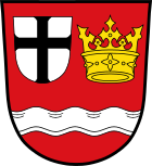
Blazon: In red over a lowered silver wavy bar next to each other a silver label, inside a black cross of deeds and a golden provost's crown.
Coat of arms history: The Schondra market that exists today was created in 1978 by merging the formerly independent communities of Schondra, Schönderling and Singenrain. Until 1803, all parts of the community were under the dominion of the prince monastery of Fulda. Administratively, Schondra belonged to the Fulda Oberamt Brückenau, while the districts of Schönderling and Singenrain were administered by the Thulba monastery provost. In the coat of arms, the Fulda cross in a small shield and the golden provost's crown indicate these rulers. The silver wave bar indicates the location of the municipality on the Schondra river . The colors silver and red are the colors of Franconia . Schondra was given the name Markt before 1600. At that time, Schondra was already a court seat.
The coat of arms was awarded by the Ministry of the Interior on January 9, 1981.
Architectural monuments
The most important architectural monuments in the community are the ruins of Schildeck Castle and the parish church of St. Anna from 1953.
Also worth mentioning are:
- the Hannesebuche at Schönderling.
- the prehistoric hillfort equipment on the Mettermich .
- the linden stump north of Schondra.
Economy and Infrastructure
Official statistics
In 2007, there were 603 employees subject to social insurance contributions at the place of residence in the municipality of Schondra and 1,036 employees subject to social insurance contributions at the place of work.
education
In Schondra there is a kindergarten and the Schondratal elementary school.
traffic
The municipality is crossed by the A 7 motorway , the B 27 and B 286 federal highways , the 2431 state road and the KG 33 and KG 34 district roads.
literature
- Leonhard Rugel: Catholic parish church Schondra. Patronage: St. Anna (July 26th). (= Art Guide No. 2144, ZDB -ID 51387-8 ). Schnell and Steiner, Regensburg 1994.
Individual evidence
- ↑ "Data 2" sheet, Statistical Report A1200C 202041 Population of the municipalities, districts and administrative districts 1st quarter 2020 (population based on the 2011 census) ( help ).
- ↑ http://www.bayerische-landesbibliothek-online.de/orte/ortssuche_action.html ? Anzeige=voll&modus=automat&tempus=+20111113/005717&attr=OBJ&val= 1580
- ↑ a b Wolf-Armin von Reitzenstein : Lexicon of Franconian place names. Origin and meaning . Upper Franconia, Middle Franconia, Lower Franconia. CH Beck, Munich 2009, ISBN 978-3-406-59131-0 , p. 202 ( limited preview in Google Book search).
- ↑ a b c Federal Statistical Office (ed.): Historical municipality directory for the Federal Republic of Germany. Name, border and key number changes in municipalities, counties and administrative districts from May 27, 1970 to December 31, 1982 . W. Kohlhammer GmbH, Stuttgart / Mainz 1983, ISBN 3-17-003263-1 , p. 739 .
- ↑ Archived copy ( Memento of the original from July 22, 2010 in the Internet Archive ) Info: The archive link was inserted automatically and has not yet been checked. Please check the original and archive link according to the instructions and then remove this notice.
Web links
- www.schondra.de
- Entry on the coat of arms of Schondra in the database of the House of Bavarian History


