Schuntersiedlung
|
Schuntersiedlung
City of Braunschweig
|
|
|---|---|
| Coordinates: 52 ° 17 ′ 46 ″ N , 10 ° 32 ′ 25 ″ E | |
| Height : | 70 m above sea level NN |
| Residents : | 1704 (December 31, 2015) |
| Incorporation : | 1934 |
| Postal code : | 38108 |
| Area code : | 0531 |
|
Location of the Schuntersiedlung in Braunschweig
|
|
|
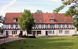
The Tostmannplatz with half-timbered houses
|
|
The Schuntersiedlung is an unofficial district in the northeast of Braunschweig in Lower Saxony between Kralenriede and the Siegfriedviertel with around 1,700 inhabitants. It is located in the district 332: Schunteraue .
history
The Schunter settlement was established in 1936 and 1937. The settlement takes its name from the river Schunter , which borders it in the north. The Schuntersiedlung was a project of the Braunschweiger Baugenossenschaft (BBG), which built 364 houses with 928 apartments there in the 1930s. This created living space for the numerous skilled workers of the “ Niedersächsische Motorenwerke GmbH Braunschweig-Querum ” (Nimo, also Niemo), which was founded in 1935 in Querumer Holz north of the Schunter.
In the 1950s and 1970s, single-family houses were built on the edge of the Schuntersiedlung. Today the settlement is a popular district with a high quality of living, especially for families, in which almost all apartments and houses have their own garden. In addition, the Schuntersiedlung is completely surrounded by landscape protection areas that are used for local recreation. The distance to the city center is around four kilometers. Adjacent are the districts of Kralenriede , Vorwerkiedlung , Siegfriedviertel and Querum .
Before the construction of the Schunter settlement, the swampy Schunteraue, often afflicted by floods from the Schunter, served as meadows and pastures as well as arable land to supply the district of Hagen. For the construction of the Schuntersiedlung, the ground was raised by around two meters, so that floods only occur very rarely, most recently in 2002 and 2013.
According to the owner, the Braunschweiger Baugenossenschaft, a larger number of the houses in the Schuntersiedlung, which has not yet been determined, are to be demolished in the next 15-20 years in order to build modern houses there. The project should start quickly. This measure, announced in the run-up to the 75th anniversary celebration in July 2012 as part of a master plan , caused uncertainty among the current tenants.
The Michelfelder settlement
The Braunschweiger Zeitung reported on the laying of the foundation stone for the Dankeskirche on November 8, 1952 in the edition of 15/16. November 1952. At that time there was only a makeshift parish in a barrack on Lauditzkamp for the residents of the district, many of whom were displaced and bombed out. At the end of April 1954, the topping-out ceremony for the church at Tostmannplatz 8 was celebrated. On August 8, 1954, the regional bishop officially inaugurated both the Dankeskirche and the “Innenplatz” and thus the new “Michelfelder settlement” with 132 rental apartments and single-family houses.
As the Braunschweiger Zeitung reported on August 9, 1954, the settlement was “ in memory of the active sponsor of the evangelical settlement work and self-sacrificing helpers in times of need […] in the name of the General Secretary of the Lutheran World Federation, Dr. Michelfelder (USA) baptized ” , whose name also bears the inner square. Sylvester Clarence Michelfelder (* 1889, † 1951) was a German-American theologian. He was Executive Secretary of the Lutheran World Federation and organized church aid for Central Europe after the end of World War II .
coat of arms
The Schuntersiedlung does not have its own coat of arms, but is represented in the coat of arms of the city district of Schunteraue. It combines the five settlements of Schuntersiedlung, Kralenriede , Bastholzsiedlung, Sandwüsten and Michelfelder-Siedlung.
The coat of arms therefore shows five blue wavy bars on a golden background on one half, which symbolizes the settlements in the Schunter area. The second half shows a golden oak leaf on a blue background. This stands for the meadow landscape. The coat of arms was designed by Peter Ohst and published for the first time in the chronicle of the 50th anniversary of the Schuntersiedlung.
literature
- M. Erdmenger, H. Meyer (Ed.): The Schuntersiedlung - The book for the 50th anniversary. Kultur- und Heimatpflegeverein Schunteraue from 1982 e. V., Braunschweig 1987, DNB 880046694 .
- Helmut Weihsmann : Building under the swastika. Architecture of doom. Promedia Druck- und Verlagsgesellschaft mbH, Vienna 1998, ISBN 3-85371-113-8 , p. 317.
Individual evidence
- ↑ Population statistics on braunschweig.de
- ↑ Flood protection on braunschweig.de
- ↑ Disputes - excitement about the planned demolition
- ↑ Section: The Michelfelder Settlement. on braunschweig.de
- ^ Arnold Rabbow: New Braunschweigisches Wappenbuch. Braunschweiger Zeitungsverlag, Meyer Verlag, Braunschweig 2003, ISBN 3-926701-59-5 , p. 27.
Web links
- Private portal on the history, present and residents of the Schuntersiedlung on schuntersiedlung-online.de
- Website of the city of Braunschweig regarding the settlement on braunschweig.de
- Page of the primary and secondary school Schuntersiedlung on ghs-schuntersiedlung.de


