
Segovia
| Segovia municipality | |||
|---|---|---|---|
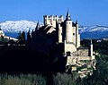
 View of Segovia with cathedral
|
|||
| coat of arms | Map of Spain | ||

|
|
||
| Basic data | |||
| Autonomous Community : | Castile and León | ||
| Province : | Segovia | ||
| Comarca : | Capital y Area Metropolitana | ||
| Coordinates | 40 ° 57 ′ N , 4 ° 7 ′ W | ||
| Height : | 1002 msnm | ||
| Area : | 163.59 km² | ||
| Residents : | 51,674 (Jan 1, 2019) | ||
| Population density : | 315.88 inhabitants / km² | ||
| Postal code : | 40001-40006 | ||
| Municipality number ( INE ): | 40194 | ||
| administration | |||
| Website : | Segovia | ||


Segovia is a historically and culturally significant city in central Spain with 51,674 inhabitants (as of January 1, 2019). It is the administrative seat of the eponymous province of Segovia in Castile and León and the seat of the Roman Catholic diocese of Segovia . In the city there is also a campus of the University of Valladolid and a location of private IE University .
Segovia, together with Toledo and Ávila, is one of the three historical metropolises in the vicinity of the Spanish capital.
Toponym
The name Segovia is derived from the Celtiberian name Segobriga , where Celtiberian brig means "castle". Translated, the name means something like "Siegeshöhe".
Location and climate
The city is located on the northwest side of the Sierra de Guadarrama about 90 km (driving distance) northwest of Madrid on an approximately 1000 m high ledge of rock that extends from east to west. The Eresma River flows north of the historic old town and the Clamores River flows south of the western tip . Both flow together at the foot of the Alcázar, the castle complex in the north-western corner of the old town surrounded by a fortification.
Climate table
| Segovia (1005 m) | ||||||||||||||||||||||||||||||||||||||||||||||||
|---|---|---|---|---|---|---|---|---|---|---|---|---|---|---|---|---|---|---|---|---|---|---|---|---|---|---|---|---|---|---|---|---|---|---|---|---|---|---|---|---|---|---|---|---|---|---|---|---|
| Climate diagram | ||||||||||||||||||||||||||||||||||||||||||||||||
| ||||||||||||||||||||||||||||||||||||||||||||||||
|
Average monthly temperatures and rainfall for Segovia (1005 m)
|
||||||||||||||||||||||||||||||||||||||||||||||||||||||||||||||||||||||||||||||||||||||||||||||||||||||||||||||||||||||||||||||||||||||||||||||||||||||||||||||||||||||||||||||||||||
Population development
| year | 1857 | 1900 | 1950 | 2000 | 2018 |
| Residents | 10,339 | 14,547 | 29,568 | 54.032 | 51,683 |
The rural exodus as a result of the mechanization of agriculture led to a significant population growth in the second half of the 20th century. In addition, several small villages in the area were incorporated into the 1970s. However, the city is growing much more slowly than the booming capital region , because the sparsely populated area offers little economic potential other than tourism .
economy
Segovia is the center of an agriculturally used region; Traders and day laborers settled in the city early on; from the latter, craft and service professions gradually developed. Two industrial parks were built in the last decades of the 20th century.
history
| Segovia old town with aqueduct | |
|---|---|
|
UNESCO world heritage |
|

|
|
| Aerial view of the aqueduct |
|
| National territory: |
|
| Type: | Culture |
| Criteria : | i, iii, iv |
| Surface: | 134.28 ha |
| Reference No .: | 311bis |
| UNESCO region : | Europe and North America |
| History of enrollment | |
| Enrollment: | 1985 (session 9) |
| Extension: | 2015 |
Legend has it that Segovia was founded by Hercules the Egyptian, a great-grandson of Noah , around 1076 BC. Founded. In the first millennium BC The Celtic Vaccaei settled here . Pliny reports of the resistance of this people against the Romans around 80 BC. Segovia appeared as a city in which a Celtic castle must have previously existed, from which the great resistance against the Romans originated. The city was captured anyway. After that, the construction began as a Roman city that has kept its Roman name. The place became an important military base for the Romans on a central route from north to south. From the 1st / 2nd The Roman aqueduct of Segovia dates from the 16th century AD .
In the second half of the 5th century Segovia became part of the Visigoth Empire . The Christianization of the region, which had already begun in Roman times, came to an end. From the 8th to the 11th century, Segovia was owned by the Moorish . The Islamic conquest is reflected - from the perspective of the Reconquista - in the story of San Frutos and his siblings. In 1085 Alfonso VI conquered . the town. It was the royal residence from the 13th to the 15th century; In 1474, Isabella was proclaimed Queen of Castile here .
In 1520 Segovia joined the Comuneros uprising . Despite its violent suppression, the city recorded economic success, so that the population had grown to around 27,000 inhabitants at the end of the 16th century. In the 17th century an economic decline followed, at the end of the century the population had dropped to approx. 8,000 inhabitants.
During the Napoleonic Wars in the Iberian Peninsula , the city was sacked in 1808.
Attractions
- The historical city center lies within the still partially preserved city wall . Segovia with its churches and numerous monuments and secular buildings is particularly worth seeing and has been a UNESCO World Heritage Site since 1985 .
- The castle complex in the west of the old town is one of the main attractions. The Alcázar is a palace fortress that rises above the confluence of the Eresma and Clamores rivers.
- The late Gothic cathedral in the center of the old town was built between 1525 and 1577 by order of Emperor Charles V. The 67 m spanning crossing dome and the 88 m high slender tower date from the 17th century in their current form.
- The aqueduct in the east of the old town is approx. 28 m high and 728 m long. It has 118 arcs and comes from the 1st / 2nd centuries. Century AD. Until 1974 it supplied the city with water from the Río Frío river, which is more than 18 km away.
- The Puerta de San Andrés , built in the 14th century, and the Torre de Lozoya are part of the former city fortifications.
- The peculiar Renaissance building of the Casa de los Picos dates from the end of the 15th century.
- There are several Romanesque churches within the old town - most of them have an arcaded south porch ( portico or galería porticada) , whose former function (court hall, meeting place, walkway, etc.) remains unclear. Particularly noteworthy are the churches: San Clemente, San Esteban, San Juan de los Caballeros, San Lorenzo, San Martín, San Millán and Santísima Trinidad , but also the churches of San Andrés, San Justo, San Nicolás, San Quirce and San Sebastián are well worth seeing.
Alcázar of Segovia (from the west)
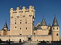
Alcázar of Segovia (from the east)

Iglesia San Esteban

Iglesia San Juan de los Caballeros

Iglesia San Martín

Torre de Lozoya

Puerta San Andrés
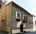
Casa de los Picos


.JPG)


- Surroundings
- The twelve-sided church of Vera Cruz , about 1 km outside the city, was founded in 1208. Unfortunately, it is not known exactly by whom. Often the Order of the Knights Templar is mentioned, but the Castilian Order of the Holy Sepulcher ( Orden del Santo Sepulcro ) is more likely .
- The best view of the city is from the Parador , the state hotel chain in Spain, a few kilometers from the city center .
- Also worth seeing is the Palacio Real of La Granja, about 11 km southeast . The palace was built on the model of the Palace of Versailles and is surrounded by a park, whose fountains and water features are all supplied with water by a lake at a higher level without additional pumps.
- The Royal Palace of Riofrío is about 14 km southwest of the city .


Museums
A number of museums can be visited in Segovia:
- Segovia Museum
- Museum of Contemporary Art 'Esteban Vicente'
- Museum of the Episcopal Palace
- Museum of the Art School
- Cathedral Museum
- Zuloaga Museum
- House-Museum of Antonio Machado
- Museum of the Rodera-Robles Foundation
- Witchcraft Museum
- Arms Museum
- City wall museum
- Gastronomy Museum
- Jewish center
Town twinning
Segovia has twinned cities with
-
 Tucson , Arizona (USA)
 -
 Tours , Center-Val de Loire (France)
 -
 Navalcarnero , Community of Madrid (Spain)
 -
Medina del Campo , Castile and León (Spain)
-
Marysville , Ohio (USA)
-
 Barquisimeto , Lara (Venezuela)
 -
 Edinburgh , Scotland (UK)
 -
Bristol , England (UK)
sons and daughters of the town
- San Frutos († after 715), legendary saint, city patron; annual city festival Romería de San Frutos on October 25th
- Dominicus Gundisalvi (1110–1181), philosopher and translator
- Berenguela of Castile (1180–1246), Queen of Castile
- Abraham Senior (1412–1493), Spanish magnate and financier
- Pedro Arias Dávila (around 1468–1531), conqueror and Spanish colonial administrator
- Domingo de Soto (1494–1560), Dominican, leading exponent of late Spanish scholasticism
- Andrés Laguna (1499–1559), physician, pharmacist, botanist and humanist
- Isabella Clara Eugenia of Spain (1566–1633), Spanish infanta and governor of the Spanish Netherlands
- Arsenio Martínez-Campos (1831–1900), general and politician
- Pedro Delgado (* 1960), former racing cyclist
- Luis Ángel de las Heras Berzal (* 1963), religious priest, Bishop of Mondoñedo-Ferrol
- Lucía Jiménez (* 1978), actress
literature
- Thomas G. Schattner (Ed.): Archaeological guide through Portugal (= cultural history of the ancient world . Vol. 74). Philipp von Zabern, Mainz 1998, ISBN 3-8053-2313-1 p. 12
Web links
Individual evidence
- ↑ Cifras oficiales de población resultantes de la revisión del Padrón municipal a 1 de enero . Population statistics from the Instituto Nacional de Estadística (population update).
- ^ Segovia - population development
- ↑ See the information in: Ganz Segovia, Editorial Escludo de oro, SA, 5th edition, ISBN 84-378-1559-2
- ↑ Hans-Peter Burmeister: Central Spain and Madrid , pp. 135f. Dumont, Cologne 2001, ISBN 3-7701-3458-3 .
- ^ Museos Segovia . Retrieved September 18, 2014.

Historic city centers:
Alcalá de Henares with university (1998) |
Ávila with churches outside the city wall (1985) |
Cáceres (1986) |
Cordoba with Mosque-Cathedral (1984) |
Cuenca (1996) |
Granada with Alhambra and Generalife Palace (1984) |
Salamanca (1988) |
San Cristóbal de La Laguna (1999) |
Santiago de Compostela (1985) |
Segovia with Aqueduct (1985) |
Toledo (1986)
Buildings:
Architecture of the Mudéjares in Aragón (1986) |
Monuments of Oviedo and the Kingdom of Asturias (1985) |
Escorial in Madrid (1984) |
Tower of Hercules (2009) |
Burgos Cathedral (1984) |
Cathedral , Alcázar and Archivo General de Indias in Seville (1987) |
Catalan Romanesque churches in the Vall de Boí (2000) |
Poblet Monastery (1991) |
Monasteries of San Millán de Yuso and San Millán de Suso (1997) |
Royal Monastery of Santa María de Guadalupe (1993) | Monumental Renaissance buildings by Úbeda and Baeza (2003) |
Palau de la Música Catalana and Hospital de la Santa Creu i Sant Pau in Barcelona (1997) |
Puente de Vizcaya (2006) |
Historic sites of mercury mining: Almadén and Idrija (2012) |
Roman city walls of Lugo (2000) |
Valencia Silk Exchange (1996) |
Works by Antoni Gaudí (1984)
Archaeological sites:
Atapuerca (2000) |
Antequera Dolmen (2016) |
Rock art of the Mediterranean on the Iberian Peninsula (1998) |
Altamira Cave and Paleolithic Cave Paintings in Northern Spain (1985) |
Las Médulas (1997) |
Madīnat az-zahrāʾ (2018) |
Mérida (1993) |
Siega Verde * (2010) |
Tarraco (2000)
Cultural and natural landscapes:
Old beech forests and primeval beech forests of the Carpathian Mountains and other regions of Europe (2017, N) |
Aranjuez (2001, K) |
Ibiza (1999, K / N) |
Way of St. James (1993, K) |
Monte Perdido (1997, K / N) |
Doñana National Park (1994, N) |
Garajonay National Park (1986, N) |
Teide National Park (2007, N) |
Palm grove of Elche (2000, K) |
Serra de Tramuntana (2011, K)
* Expansion of the archaeological sites in Vale do Côa , Portugal;
Abades | Adrada de Pirón | Adrados | Aguilafuente | Alconada de Maderuelo | Aldea Real | Aldealcorvo | Aldealengua de Pedraza | Aldealengua de Santa María | Aldeanueva de la Serrezuela | Aldeanueva del Codonal | Aldeasoña | Aldehorno | Aldehuela del Codonal | Aldeonte | Anaya | Añe | Arahuetes | Arcones | Arevalillo de Cega | Armuña | Ayllón | Barbolla | Basardilla | Bercial | Bercimuel | Bernardos | Bernuy de Porreros | Boceguillas | Brieva | Caballar | Cabañas de Polendos | Cabezuela | Calabazas de Fuentidueña | Campo de San Pedro | Cantalejo | Cantimpalos | Carbonero el Mayor | Carrascal del Río | Casla | Castillejo de Mesleón | Castro de Fuentidueña | Castrojimeno | Castroserna de Abajo | Castroserracín | Cedillo de la Torre | Cerezo de Abajo | Cerezo de Arriba | Chañe | Cilleruelo de San Mamés | Cobos de Fuentidueña | Coca | Codorniz | Collado Hermoso | Condado de Castilnovo | Corral de Ayllón | Cozuelos de Fuentidueña | Cubillo | Cuéllar | Cuevas de Provanco | Domingo García | Donhierro | Duruelo | Encinas | Encinillas | Escalona del Prado | Escarabajosa de Cabezas | Escobar de Polendos | El Espinar | Espirdo | Fresneda de Cuéllar | Fresno de Cantespino | Fresno de la Fuente | Frumales | Fuente de Santa Cruz | Fuente el Olmo de Fuentidueña | Fuente el Olmo de Íscar | Fuentepelayo | Fuentepiñel | Fuenterrebollo | Fuentesaúco de Fuentidueña | Fuentesoto | Fuentidueña | Gallegos | Garcillán | Gomezserracín | Grajera | Honrubia de la Cuesta | Hontalbilla | Hontanares de Eresma | Los Huertos | Ituero y Lama | Juarros de Riomoros | Juarros de Voltoya | Labajos | Laguna de Contreras | Languilla | Lastras de Cuéllar | Lastras del Pozo | La Lastrilla | La Losa | Maderuelo | Marazoleja | Marazuela | Martín Miguel | Martín Muñoz de la Dehesa | Martín Muñoz de las Posadas | Marugán | Mata de Cuéllar | Matabuena | La Matilla | Melque de Cercos | Membibre de la Hoz | Migueláñez | Montejo de Arévalo | Montejo de la Vega de la Serrezuela | Monterrubio | Moral de Hornuez | Mozoncillo | Muñopedro | Muñoveros | Nava de la Asunción | Navafría | Navalilla | Navalmanzano | Navares de Ayuso | Navares de Enmedio | Navares de las Cuevas | Navas de Oro | Navas de Riofrío | Navas de San Antonio | Nieva | Olombrada | Orejana | Ortigosa de Pestaño | Ortigosa del Monte | Otero de Herreros | Pajarejos | Palazuelos de Eresma | Pedraza | Pelayos del Arroyo | Perosillo | Pinarejos | Pinarnegrillo | Pradales | Prádena | Puebla de Pedraza | Rapariegos | Rebollo | Remondo | Riaguas de San Bartolomé | Riaza | Ribota | Riofrío de Riaza | Roda de Eresma | Sacramenia | Samboal | San Cristóbal de Cuéllar | San Cristóbal de la Vega | San Cristóbal de Segovia | San Ildefonso | San Martín y Mudrián | San Miguel de Bernuy | San Pedro de Gaíllos | San Rafael | Sanchonuño | Sangarcía | Santa María la Real de Nieva | Santa Marta del Cerro | Santiuste de Pedraza | Santiuste de San Juan Bautista | Santo Domingo de Pirón | Santo Tome del Puerto | Sauquillo de Cabezas | Sebúlcor | Segovia | Sepúlveda | Sequera de Fresno | Sotillo | Sotosalbos | Tabanera la Luenga | Tolocirio | Torre Val de San Pedro | Torreadrada | Torrecaballeros | Torrecilla del Pinar | Torreiglesias | Trescasas | Turégano | Urueñas | Valdeprados | Valdevacas de Montejo | Valdevacas y Guijar | Valle de Tabladillo | Vallelado | Valleruela de Pedraza | Valleruela de Sepúlveda | Valseca | Valtiendas | Valverde del Majano | Veganzones | Vegas de Matute | Ventosilla y Tejadilla | Villacastín | Villaverde de Íscar | Villaverde de Montejo | Villeguillo | Yanguas de Eresma | Zarzuela del Monte | Zarzuela del Pinar