
Solar eclipse of December 14, 2001
| Solar eclipse of December 14, 2001 | |
|---|---|

|
|
| classification | |
| Type | Ring-shaped |
| area |
Pacific , North and Central America , Northwest South America Annular: Central Pacific , Costa Rica |
| Saros cycle | 132 (45 of 71) |
| Gamma value | 0.4088 |
| Greatest eclipse | |
| Duration | 3 minutes and 53 seconds |
| place | Pacific |
| location | 0 ° 38 ′ N , 130 ° 42 ′ W |
| time | December 14, 2001 20:51:57 UT |
| size | 0.9681 |
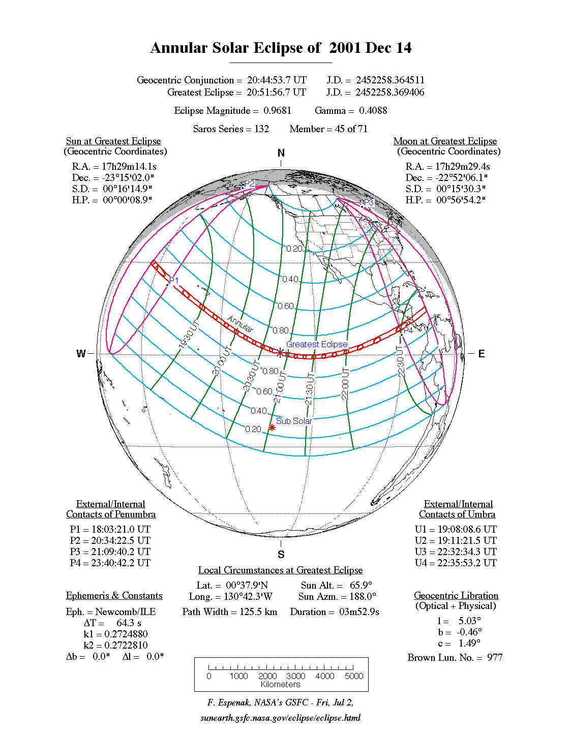
The annular solar eclipse of December 14, 2001 took place largely over the Pacific . Only at the end did the zone with circular visibility cross Central America .
course
The ring-shaped phase began in the middle of the northern Pacific, a little west of the date line , therefore actually on December 15th according to local time. The zone of the ring-shaped eclipse initially ran in a south-easterly direction, the maximum occurred in the middle of the Pacific at 20:51:75 UT . Shortly thereafter, the eclipse corridor crossed the equator and ran east, but then turned increasingly to the northeast, so that the corridor soon switched back to the northern hemisphere.
Just before the end of the eclipse, the annular visibility zone crossed Costa Rica and Nicaragua , where the eclipse could be seen in the local evening hours of December 14th. It ended shortly afterwards in the Caribbean.
Partly the eclipse could be seen next to a large part of the Pacific of North and Central America as well as of northwestern South America .
literature
- Hans-Ulrich Keller (Ed.): Kosmos Himmelsjahr 2001 . Franckh-Kosmos, Stuttgart 2000, ISBN 3-440-08120-6 .
Web links
- solar-eclipse.de: The ring-shaped solar eclipse of December 14, 2001
- NASA: Total Solar Eclipse of 2001 Dec 14
- NASA: Google Maps and Solar Eclipse Paths: 2001–2020
- Solar Eclipses of Saros 132
|
Previous solar eclipses:
|
Later solar eclipses:
|
|||||||||
|
February 5, 2000 (partial) |
July 1, 2000 (partial) |
July 31, 2000 (partial) |
December 25, 2000 (partial) |
June 21, 2001 (total) |
December 14, 2001 (circular) |
June 10, 2002 (circular) |
December 4, 2002 (total) |
May 31, 2003 (circular) |
November 23, 2003 (total) |
April 19, 2004 (partial) |
|
|
|
|
|
|
|
|
|
|
|
|
| Lists: 20th century • 21st century • All lists | ||||||||||