Steeg (Tyrol)
|
Steeg
|
||
|---|---|---|
| coat of arms | Austria map | |
|
|
||
| Basic data | ||
| Country: | Austria | |
| State : | Tyrol | |
| Political District : | Reutte | |
| License plate : | RE | |
| Surface: | 67.95 km² | |
| Coordinates : | 47 ° 15 ' N , 10 ° 18' E | |
| Height : | 1122 m above sea level A. | |
| Residents : | 662 (January 1, 2020) | |
| Postal code : | 6655 | |
| Area code : | 05633 | |
| Community code : | 7 08 31 | |
| NUTS region | AT331 | |
| Address of the municipal administration: |
Steeg 30 6655 Steeg |
|
| Website: | ||
| politics | ||
| Mayor : | Günther Walch ( community list ) | |
|
Municipal Council : (2016) (11 members) |
||
| Location of Steeg in the Reutte district | ||
 Aerial view of the upper Lech Valley (in the foreground Steeg, then Hägerau , Holzgau ) |
||
| Source: Municipal data from Statistics Austria | ||
Steeg is a municipality with 662 inhabitants (as of January 1, 2020) in the Reutte district in Tyrol ( Austria ).
geography
Steeg is the first place in the uppermost Tyrolean Lech Valley and the westernmost place in the Reutte district .
The community area covers 6,799.76 hectares, of which are:
- 11.82 hectares of construction area
- 391.89 ha used for agriculture
- 3,253.16 hectares of Alps (mountain pastures and alpine pastures)
- 1,444.19 hectares of forest
- 44.34 hectares of water
- 36.63 ha federal road
- 1,617.73 hectares of other areas
- 10.89 hectares of trails
- 0.08 ha cemetery
- 0.60 ha sports field
- 2.36 hectares of various sites
- 1,603.80 hectares unproductive
Community structure
Steeg consists of a single cadastral municipality of the same name or five localities (residents as of January 1, 2020):
- Dickenau (95)
- Haegerau (185)
- Dorsal elbow (73)
- Lechleiten (65)
- Steeg (244)
The districts are several villages and hamlets , such as Walchen, Hägerau , Ebene, Dickenau, Steeg, Hinterellenbogen, Prenten , at the end of the Lech Gorge are Lechleiten and Gehren (both belong to the diocese of Feldkirch ).
Neighboring communities
|
Warth ( Bregenz district ) |
Oberstdorf (Bavaria) | |
|
Lech ( Bludenz district ) |

|
Holzgau |
| Emperor |
history
Steeg was first mentioned in a document in 1427. The first settlers were the Walsers , who fled their old homeland.
Population development

politics
The municipal council has 11 members.
In the 2016 municipal council elections, the municipal list received 11 seats.
- mayor
- since May 16, 1999 Günther Walch (community list)
coat of arms
A black arch bridge spans a vertical, silver wavy ribbon on a green surface. This represents the river crossing mentioned in the late Middle Ages, after which the municipality was named.
Culture and sights
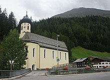
- Parish church Steeg , 1122 m above sea level
- Hägerau Church, 1107 m
- Lechleiten chapel, 1539 m
- Gehren Chapel, 1465 m
economy
- The central dairy for the upper Lech Valley is located in Steeg. There are a total of 33 livestock farms (including 27 cattle farms).
- In 2010, tourism generated an overnight volume of 86,743 overnight stays for tourism companies.
traffic
- From Steeg, the Lechtalstraße B 198 leads uphill to the Vorarlberg community of Warth and further over the Hochtannbergpass into the Bregenzerwald and down the valley to the district capital Reutte .
- The road to Kaisers branches off from Steeg to the south .
societies
- Mountain rescue center Steeg
- Mountain rescue station Steeg
- Ice sports club Steeg
- Voluntary fire brigade Steeg
- Young farmers / rural youth Steeg
- Hägerau music band
- Music band Steeg
- Rifle Guild Steeg
- Rifle company Steeg
- Social circle Steeg / Kaisers
- Sports club Steeg
- Theater group Steeg
- Hägerau cattle breeding association
- Viehzuchtverein Hinterellenbogen
- Lechleiten cattle breeding association
- Viehzuchtverein Steeg
- Viehversicherungsverein Steeg
Personalities
Honorary citizen
- 1994: Paul Scharf, shoe manufacturer
Sons and daughters of the church
- Anna Dengel (1892–1980), founder of the Congregation of Medical Missionary Sisters
Web links
- 70831 - Steeg. Community data, Statistics Austria .


