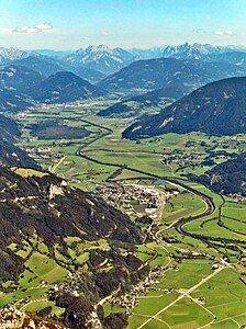
Styrian Ennstal
| Styrian Ennstal | ||
|---|---|---|
| location | Liezen District , Upper Styria , Styria , Austria | |
| Waters | Enns | |
| Mountains | Central Eastern Alps / Northern Limestone Alps | |
| Geographical location | 47 ° 32 ' N , 14 ° 8' E | |
|
|
||
| length | 90 km | |
The Styrian Ennstal is one of the major landscapes of Styria and includes the central reaches of the Enns . The political district of Liezen roughly corresponds to the Styrian Ennstal.
description
The valley extends for about 90 kilometers from west to east between the Mandling Pass and the Gesäuse . The former is the valley pass where the Enns from the Ennspongau (the Salzburg Ennstal) reaches Styria. The second is the Engtal section, after which the Enns bends northwards and flows into the Danube in the breakthrough valley of the Upper Austrian Ennstal . The Landl behind the Gesäuse on the knee with the Salzam estuary is mostly still part of the Styrian Ennstal. The Hinterberg can be counted as a side valley to the Ennstal or seen independently as part of the Styrian Salzkammergut .
In the south, the eastern Central Alps with the Schladminger Tauern and Rottenmanner Tauern (northeastern Niederen Tauern ) and the Ennstal Alps extend , in the north one of the central sections of the Northern Limestone Alps , Dachstein Mountains and Dead Mountains (Styrian-Upper Austrian Limestone Alps). The Ennstal is part of the Salzach-Enns-Längstalfurche, which follows the geological disturbance of the SEMP line (Salzach-Ennstal-Mariazell-Puchberg), i.e. continues over the Salzatal, while the morphologically dominant Längstal over the Palten-Liesing-Tal into the Mur-Mürz furrow changes. The Palten-Liesing valley separates the Rottenmanner Tauern and Ennstal Alps, some of which still belong to the Limestone Alps. The Hinterberg separates the Dachstein massif and Grimmingstock from the Dead Mountains . At the east end are the Styrian-Lower Austrian Limestone Alps (with the Hochschwab Group and Ybbstal Alps ).
In terms of spatial planning, the Styrian Ennstal is again divided into Upper Ennstal (roughly the Expositur Gröbming ), the (Styrian) Middle Ennstal and the Gesäuseregion (which is oriented towards Gesäuse and Eisenwurzen ).

