
Star Rock
| coat of arms | Germany map | |
|---|---|---|

|
Coordinates: 49 ° 3 ' N , 8 ° 51' E |
|
| Basic data | ||
| State : | Baden-Württemberg | |
| Administrative region : | Karlsruhe | |
| County : | Enzkreis | |
| Height : | 397 m above sea level NHN | |
| Area : | 17.31 km 2 | |
| Residents: | 2867 (Dec. 31, 2018) | |
| Population density : | 166 inhabitants per km 2 | |
| Postal code : | 75447 | |
| Primaries : | 07045, 07043 | |
| License plate : | PF | |
| Community key : | 08 2 36 061 | |
| LOCODE : | DE SF9 | |
| Address of the municipal administration: |
Maulbronner Strasse 7 75447 Sternenfels |
|
| Website : | ||
| Mayoress : | Antonia Walch | |
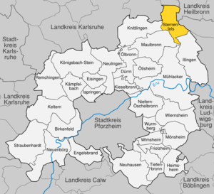
| Location of the municipality of Sternenfels in the Enzkreis | ||
  |
||


Sternenfels is the northernmost municipality in the Enzkreis in Baden-Württemberg . It is located between Kraichgau and Stromberg approx. 20 km as the crow flies in a north-easterly direction from the district town of Pforzheim .
Due to its particularly exposed location and surroundings, as well as the special bond between the Sternenfels people and their community, Sternenfels is and was the subject of numerous municipal political studies and investigations - including in the area of village development for Dutch model planning , in the area of employment concepts for rural areas or based on the so-called Sternenfels survey for teleworking .
In and for Baden-Württemberg , at the EXPO 2000 and several congresses, also on a European level , Sternenfels was cited as a prime example of planning in rural areas.
geography
Geographical location
Sternenfels lies on the western foothills of the Stromberg basin , which is characterized by a reversal of relief and running east-west. The watershed between the Rhine and Neckar runs through Sternenfels in the transition area between Kraichgau and Stromberg. In the district of Diefenbach is the source of the Metter , which drains over the Enz into the Neckar, in Sternenfels that of the Kraichbach , which flows directly into the Rhine.
With the exception of viticulture in Sternenfels and the suburb of Diefenbach, agriculture was rather subordinate. The early industrialization, which began in the local quarries and in the production of parlor sand , a cleaning and abrasive agent that used to be very common, was important. Sternenfels was also known for its basket making . Sternenfels is still an industrial village today; many residents work as part-time farmers .
The centrality and rulership function of the former castle of the Lords of Sternenfels can still be felt in the layout of the place.
The exposed location - also recognizable by the location and the meeting of the four districts ( Karlsruhe , Heilbronn , Ludwigsburg and Enzkreis ) - later also predestined Sternenfels as a regional excursion destination with several breweries and restaurants and the starting point for hiking routes. Sternenfels is located on the Württemberger Weinstrasse , which leads from Weikersheim to Metzingen .

The neighboring communities of Sternenfels clockwise are, starting in the west: Knittlingen (Enzkreis), Oberderdingen , Kürnbach (both districts of Karlsruhe), Zaberfeld (districts of Heilbronn), Sachsenheim (districts of Ludwigsburg), Illingen and Maulbronn (both Enz districts).
Community structure
Since the community reform in the 1970s, the formerly independent community of Diefenbach with the hamlet of Füllmenbacher Hof and the courtyards of Burrainhof and Mettenbacher Mühle has belonged to the municipality of Sternenfels . The deserted Waldbruderhütte lies in the area of the former municipality of Sternenfels .
history


Since the High Middle Ages, the Sternenfels castle of the Lords of Kürnbach existed in Sternenfels , who made it their ancestral seat and henceforth called themselves Lords of Sternenfels . The white parlor sandstone near Sternenfels was already dismantled as building material for the construction of the castle and finer qualities were used in the neighboring Häfnerhaslach for the Häfner and pottery. In Sternenfels, the quarries were an important line of business for the residents of the hamlet below the castle. Sternenfels came to Württemberg in the course of the 14th century . The place was devastated in the Thirty Years War and then lay fallow for some time. Towards the end of the 17th century, some of the ramparts and moats of the Eppinger Lines were built in and around Sternenfels. The castle was demolished in 1778.
In the middle of the 18th century a separate line of business developed, sand construction , in which sandstone was ground into abrasive sand . Around 1860 there were around 35 sand mills in Sternenfels and many Sternenfels people worked as sand farmers . The community forest on the Sandberg suffered a lot from the excessive stone mining, so that around 1920 the removal of Stubensandstein was prohibited. At the same time, due to changed floor coverings and cleaning materials, the demand for room sand also fell, so that the last sand mill closed in 1935. The Stubensandstein is goldhöffig to a small extent, which u. a. by Christopher Bechtler was trying to exploit. Bechtler, who comes from Pforzheim , was not very successful with a gold panning attempt in Sternenfels in 1818, but became a millionaire with his own right to mint during the gold rush in the USA and, among other things, minted the first gold dollars.
The important role of industry was also noticeable politically, the so-called Sternenfelser workers' association was founded in Sternenfels as early as 1875, the tradition of which the local SPD still invokes today - and regularly achieves results of 50% in elections, which in Baden-Württemberg as in the environment is exceptional.
During the Bismarck Socialist Laws as well as during the Third Reich, Sternenfelser, who suffered from their reputation as the “Red Village”, moved to more apolitical associations such as the Volkschor and the Badverein. In the last free Reichstag elections in 1932, the SPD achieved 33.7%, the KPD 45% and the NSDAP 15.2%. A joint list of the SPD and KPD never came about. As early as 1922, the SPD in Sternenfels tried to win votes from local farmers and wine growers. After the war, in the first free local elections in 1947, the SPD won 4 seats in the local council, the KPD 3 and the Free Voters 5.
Sternenfels was originally administered by the Württemberg Oberamt Güglingen , from 1816 it belonged to the Oberamt Maulbronn and after 1938 to the district of Vaihingen , which became part of the Enzkreis in 1973. Today's community was created on January 1, 1974 through the merger of the two communities of Sternenfels and Diefenbach.
politics
Municipal council
The municipality council in Sternenfels has 12 members. The local elections on May 26, 2019 led to the following preliminary final result. The turnout was 69.44% (2014: 63.2%). The municipal council consists of the elected voluntary councilors and the mayor as chairman. The mayor is entitled to vote in the municipal council.
| Political party | be right | Seats | 2014 result |
| Free voters | 52.30% | 6th | 41.8%, 5 seats |
| List for Sternenfels and Diefenbach | 35.33% | 4th | 30.1%, 5 seats |
| SPD | 12.37% | 2 | 20.1%, 2 seats |
mayor
- 1970–1974: Horst Jung
- 1974-2006: Helmut Wagner
- 2006–2015: Sigrid Hornauer
- from 2015 : Werner Weber
Town twinning
Culture and sights
Buildings and special features

- The Schlossberg Tower , a 14 meter high water and observation tower in Sternenfels has a capacity of 150 cubic meters of water and was founded in 1967 on the 375.4 m high Schlossberg in the style of the keep built. In the tower there is also an exhibition on the history of the Lords of Sternenfels and the geology of the Stromberg and Heuchelberg .
- The Protestant Michaelskirche in Sternenfels was built as a wooden church at the beginning of the 18th century, but it was already dilapidated in 1750 and was replaced by a new stone building with a north-east tower and south-west choir in 1751. Since the church renovation in 1964, two windows have been designed by the Sternenfels family with the Sternenfels coat of arms and the Luther rose . The large choir window on the theme of "Last Supper - Jesus Invites Everyone" was designed by the artist Elmar Lindner, who mainly works in northern Germany. Since 1964 the church has been named Michaelskirche in echoes of the medieval Michaelskapelle below the castle .
- The Protestant Holy Cross Church in Diefenbach was in 1621 on the orders of the Württemberg Duke Johann Friedrich and the monastery Maulbronn , designed by Heinrich Schickhardt to the north and west, and by incorporating a large west gallery as a cross church with a simple truss - roof built practically new, only the Early Gothic tower with a choir vault on a Romanesque foundation and the south wall remained. The stalls were aligned with the pulpit on the new north wall and the church was designed in Renaissance style inside and outside with corresponding scrollwork around the windows and doors and on the tower, seven preserved wall paintings of originally twelve apostles and an artistically worked stone column as a central support of the west gallery. In order to create more seats, a new pulpit in rural Baroque style was placed on the south wall in 1771, the now free north wall and the choir with galleries as well as the choir with parterre stalls and after removal of the Gothic vault equipped with an organ gallery, whereby the transverse church Character was expressed even more clearly. The renovation in 1968 under architect Walter Schink from Stuttgart reversed these fixtures and moved the pulpit to its current location on the choir arch and the organ on its other side. In 1934 the artist Adolf Hess (1893–1953) from Bietigheim-Bissingen created two colored windows with the Saile glass painting workshop in Stuttgart ("Resurrection" in the east window of the tower, "Birth of Christ" originally in the west window, since the renovation in 1968 in the south window of the choir) .
- The Sternenfels outdoor pool , built in 1939, is a specialty in such a small community and is considered one of the most beautiful outdoor pools in the district due to its integration into the landscape. The open-air swimming pool club Sternenfels, which was founded in 1969, is one of the most important local associations and citizens' initiatives with over six hundred members, and in the following years ensured a fundamental renewal. The members still share lifeguards today.
- The real multi-purpose hall near the Kraichquelle, cemetery and open-air swimming pool , which is used both for sport and as a sanctuary for funeral celebrations, is typical of the willingness to adopt unusual, Swabian-economical municipal solutions in Sternenfels .
- The newly built community center is named after the pietistic preacher and early SPD member of the state parliament, Christoph Blumhardt .

Ev. Michaelskirche Sternenfels
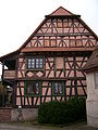
Half-timbered house from 1674 in Diefenbach


education
In addition to the state elementary school in Sternenfels, there is also the Diefenbach Free School (elementary, secondary and secondary school ), which is based on Rudolf Steiner's pedagogy.
Personalities
- August Schmidt (1840–1929): geophysicist and meteorologist
- Friedrich Veit (1871–1913), dialect researcher
- Rudolf Stahlecker (1898–1977), geologist and vertebrate palaeontologist , brother of Franz Walter Stahlecker
- Franz Walter Stahlecker (1900–1942), lawyer, police officer and SS leader, mass murderer, born in Sternenfels,
- Horst Krautter (1933–1996), administrative expert and local politician
Web links
- Internet presence of the municipality of Sternenfels
- Sternenfels in the Stadtwiki Pforzheim-Enz
- District of Diefenbach in the Pforzheim-Enz city wiki
Individual evidence
- ↑ State Statistical Office Baden-Württemberg - Population by nationality and gender on December 31, 2018 (CSV file) ( help on this ).
- ↑ Announcement of the result of the election of the mayor of the municipality of Sternenfels. (PDF; 417 KB) July 26, 2020, accessed on August 21, 2020 .
- ^ Ministry for Rural Areas, Agriculture and Forests Baden-Württemberg (ed.) (1987): Village development - landscape and settlement ecological principles. Model planning - Dutch in Sternenfels.- Stuttgart.
- ↑ Glaser, WR / Glaser, MO / Kuder, T .: Population survey on the innovation center “Factory Schweitzer” and teleworking in Sternenfels; Final report.
- ↑ Archived copy ( memento of the original from July 19, 2011 in the Internet Archive ) Info: The archive link was inserted automatically and has not yet been checked. Please check the original and archive link according to the instructions and then remove this notice. (PDF; 601 kB) European model village and excellent experience with teleworking
- ^ The state of Baden-Württemberg. Official description by district and municipality. Volume V: Karlsruhe District Kohlhammer, Stuttgart 1976, ISBN 3-17-002542-2 . Pp. 552-553
- ^ Gold rush in Sternenfels 1818 ( Memento from February 11, 2012 in the Internet Archive )
- ↑ a b c [1] Speech on the 125th anniversary of the SPD Sternenfels 2000, OV Webpage, accessed 10/2008
- ^ Federal Statistical Office (ed.): Historical municipality directory for the Federal Republic of Germany. Name, border and key number changes in municipalities, counties and administrative districts from May 27, 1970 to December 31, 1982 . W. Kohlhammer, Stuttgart / Mainz 1983, ISBN 3-17-003263-1 , p. 490 .
- ↑ Map services of the Federal Agency for Nature Conservation ( information )
- ↑ Lookout towers & nature views> Sternenfels on the website of Kraichgau-Stromberg Tourismus e. V.
- ^ Festschrift 250 Years of the Evangelical Church in Sternenfels 1751-2001 ; ed. Ev. Kirchengemeinde Sternenfels, Sternenfels 2001
- ^ Martin Moravek: The Evangelical Parish Church in Diefenbach near Maulbronn ; Illingen 1986
- ↑ Sternenfels: educational institutions

Birkenfeld | Eisingen | Angel Brand | Friolzheim | Heimsheim | Illingen | Ispringen | Kämpfelbach | Pressing | Kieselbronn | Knittlingen | Königsbach stone | Maulbronn | Mönsheim | Mühlacker | Neuenbürg | Neuhausen | Newbies | Niefern-Öschelbronn | Ölbronn-Dürrn | Ötisheim | Remchingen | Star Rock | Straubenhardt | Tiefenbronn | Wiernsheim | Wimsheim | Wurmberg