Tiruvannamalai (District)
| Tiruvannamalai District திருவண்ணாமலை மாவட்டம் |
|
|---|---|

|
|
| State | Tamil Nadu |
| Administrative headquarters : | Tiruvannamalai |
| Area : | 6,188 km² |
| Residents : | 2,464,875 (2011) |
| Population density : | 398 inhabitants / km² |
| Website : | tiruvannamalai.tn.nic.in |
The Tiruvannamalai district ( Tamil : திருவண்ணாமலை மாவட்டம் ; also: Thiruvannamalai ) is a district of the Indian state of Tamil Nadu . The administrative center of the district is the eponymous city of Tiruvannamalai . The Tiruvannamalai district has an area of 6,188 square kilometers and around 2.5 million inhabitants (2011 census).
geography

The Tiruvannamalai District is located in the northeastern interior of Tamil Nadu. Neighboring districts are Kanchipuram in the northeast, Viluppuram in the southeast, Dharmapuri in the west, Krishnagiri in the northwest and Vellore in the north.
With an area of 6,188 square kilometers, the Tiruvannamalai District is the third largest district of Tamil Nadu. Most of the district area is flat. In the northwest on the border with the district of Vellore, however, rise the Javadi Mountains , an extension of the Eastern Ghats . The plains are also interspersed here and there with isolated individual mountains such as the 817 meter high Arunachala , at whose feet the city of Tiruvannamalai lies. The Cheyyar and Ponnaiyar rivers flow through the district .
In the district of Tiruvannamalai there is a humid tropical climate . The annual mean temperature in Tiruvannamalai is 28.2 ° C, the annual mean precipitation is 1,033 mm. Most of the rainfall occurs during the northeast monsoon in October and November. Rainfalls also occur during the southwest monsoon between July and September.
history
In the 7th and 8th centuries, the area of today's district and that of the neighboring district of Viluppuram to the east were under the control of the Pallavas residing in Kanchipuram , on whose behalf several rock temples (e.g. near Mamandur ) and the oldest open-air temples in South India (e.g. B. at Panamalai ). From the 9th century on, the Chola dominated the area. In the 10th century the area was under the rule of the central Indian Rashtrakuta dynasty before the Cholas recaptured the city and the surrounding area of Tiruvannamalai during the reign of Rajarajas I. From the 13th century onwards, the region was ruled by several successive empires: the Pandya , Hoysala , Vijayanagar , the Nayaks and the Nawabs of Arcot . In the 18th century, the colonial powers Great Britain and France fought for supremacy in southern India in the Carnatic Wars . In 1760 the British achieved a decisive victory at the Battle of Wandiwash (Vandavasi), with which they consolidated their rule.
When the Nawab of Arcot ceded his possessions to the British East India Company in 1801, the British incorporated the area of Viluppuram as part of the North Arcot district into the Madras presidency . After Indian independence in 1947, North Arcot came to the state of Madras, which was reorganized in 1956 according to the language borders of Tamil and renamed Tamil Nadu in 1969 . In 1989, the North Arcot District was divided into the Tiruvannamalai-Sambuvarayar Districts (now Tiruvannamalai District) and North Arcot Ambedkar (now Vellore District ).
population
According to the 2011 Indian census, the Tiruvannamalai district has 2,464,875 inhabitants. The population density of 398 people is less than the state average (555 people per square kilometer). The district has a rural character: only 20 percent of the population live in cities. The degree of urbanization is thus significantly lower than the mean value in Tamil Nadu (48 percent). 23 percent of the district's residents are members of the lower castes ( Scheduled Castes ) and just under 4 percent are members of the tribal population ( Scheduled Tribes ). At 74 percent, the literacy rate is well below the state average (80 percent).
According to the 2011 census, Hindus make up the vast majority of the residents of the Tiruvannamalai district with 93 percent. There are also smaller minorities of Muslims (4 percent) and Christians (3 percent). The main language in the district Tiruvannamalai is like all over Tamil Nadu, the Tamil . According to the 2001 census, 97 percent of the district's residents speak it as their first language.
Attractions
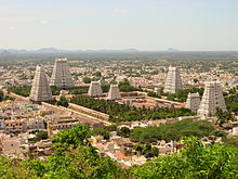
The main tourist attraction of the district is the city of Tiruvannamalai , located at the foot of the Arunachala Mountain . The Arunachaleshwara temple there, dedicated to the Hindu god Shiva as "Lord of the Arunachala Mountain", is one of the most important examples of Tamil Nadu temple architecture. The sanctuary was sung about by the Shivaite poet saints ( Nayanmar ) as early as the 7th and 8th centuries , but the temple in its current form essentially dates from the 16th to 17th centuries . Century back. As is typical of the South Indian Dravida style , the ten hectare temple complex is divided into several areas that are concentrically grouped around the main shrine. The outermost surrounding wall is crowned by four huge gopurams (gate towers).
Tiruvannamalai City was the place of activity of the Hindu guru Ramana Maharshi (1879–1950). The ashram he founded continues to attract those interested in spirit from all over the world.
In the village of Seeyamangalam, 60 kilometers northeast of Tiruvannamalai, there are two historical cave temples : a Shivaite cave temple from the 7th and a Jain from the 9th century. Another Jain shrine is located in Tirumalai near Polur .
Cities
There are 1,103 villages and the following 14 cities in the Tiruvannamalai District:
| city | Population (2011) |
|---|---|
| Arani | 63,671 |
| Chengam | 26,980 |
| Chetpet | 19,827 |
| Desur | 4,597 |
| Calambur | 14.304 |
| Kannamangalam | 7,399 |
| Kilpennathur | 13,718 |
| Peranamallur | 5,801 |
| Polur | 28,123 |
| Pudupalayam | 11,382 |
| Tiruvannamalai | 145.278 |
| Tiruvethipuram | 37,802 |
| Vandavasi | 31,320 |
| Vettavalam | 15,506 |
Individual evidence
- ↑ Census of India 2011: Primary Census Abstract - Tamil Nadu. (PDF; 873 kB)
- ↑ Climate data from climate-data.org .
- ^ Census of India 2011: Primary Census Data Highlights - Tamil Nadu. Chapter - I Population, Size and Decadal Change.
- ^ Census of India 2011: Primary Census Data Highlights - Tamil Nadu. Chapter - II Scheduled Castes and Scheduled Tribes Population.
- ^ Census of India 2011: Primary Census Data Highlights - Tamil Nadu. Chapter - III Literates and Literacy Rate.
- ^ Census of India 2011: C-1 Population By Religious Community. Tamil Nadu.
- ↑ Census of India 2001: C-15: Population by Mother Tongue (Tamil Nadu), accessed under Tabulations Plan of Census Year - 2001 .
- ↑ Query under Census of India 2011: Villages / Towns Directory - 2011.
- ↑ Query under Census of India 2011: Search PCA Data by District / SubDistrict / Town / Village Name .

