
Trenčiansky kraj
| Trenčiansky kraj | |||
|
|||
  |
|||
| Parent state | Slovakia | ||
| Type of administrative unit | Kraj | ||
| Administrative division | 9 okresy | ||
| surface | 4,502 km² | ||
| Residents | 584,569 (December 31, 2019) | ||
| Population density | 129.85 inhabitants / km² | ||
| Language (s) | Slovak , Czech | ||
| Religion (s) | Roman Catholic | ||
| Nationality (s) | Slovaks , Czechs | ||
| Administrative seat / capital | Trenčín | ||
| Code number / character | 03 | ||
| Telephone code | +421 | ||
| Time zone | UTC +1 | ||
| Code according to ISO 3166-2 | SK-TC | ||


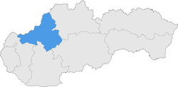
The Trenčiansky kraj (German Trentschiner Landschaftsverband ) is an administrative area in north-western Slovakia .
Okresy

The Kraj consists of the following 9 districts ( okresy ):
- Bánovce nad Bebravou
- Ilava
- Myjava
- Nové Mesto nad Váhom
- Partizánske
- Považská Bystrica
- Prievidza
- Puchov
- Trenčín
geography


The Kraj has 4,502 km² and 584,569 inhabitants (as of December 31, 2019) and is located in north-western Slovakia. The landscape is mostly shaped by the low mountain ranges of the Carpathians ; only in the south does the great Danube lowlands extend into the area of Nové Mesto nad Váhom and Partizánske . In the west, a small part of the Little Carpathians and part of the Myjavská pahorkatina hills belong to the Kraj. The White Carpathians in the northwest, together with the Javorníky in the far north, form the border with Moravia . They are separated from the mountains further to the east such as Strážovské vrchy or Inowetz by the Waagal valley. In the east of Krajs the boiler of the river Nitra, surrounded by is Bird Mountain , Žiar and small parts of the Little Fatra and Kremnica Hills . Significant rivers in the Kraj are the Waag and Nitra (Neutra) already mentioned . In the west there is also a short section from the Myjava river to the Kraj. The highest mountain is Vtáčnik in the Vogel Mountains ( 1346 m nm ); the lowest point is on the Waag at Horná Streda ( 165 m nm ).
There are five protected landscape areas in the Kraj: Malé Karpaty (Little Carpathians), Biele Karpaty (White Carpathians), Strážovské vrchy , Kysuce and Ponitrie (Nitra region, Tribeč Mountains and Bird Mountains ).
Administratively, the Kraj borders on the Žilinský kraj in the north and east, Banskobystrický kraj in the south-east, Nitriansky kraj in the south, Trnavský kraj in the south and south-west and the Czech Jihomoravský kraj and Zlínský kraj in the north-west.
Historical administrative units
In the Kingdom of Hungary , the area was largely divided into two counties: The Waag Valley to (exclusively) Nové Mesto nad Váhom and the area of Bánovce nad Bebravou were part of Trenčín County ; the regions of Myjava and Nové Mesto nad Váhom and Neutratal belonged to Neutra County . A small part of today's Partizánske was part of Persch County .
Development after the collapse of Austria-Hungary in 1918:
- 1918 / 1919–1922: as above, Czechoslovakia
- 1923–1928: Bratislavská župa (Bratislava County), Považská župa (Waager County) and Nitrianska župa (Neutra County), Czechoslovakia
- 1928–1939: Slovenská krajina / zem (Slovak Land), Czechoslovakia
- 1940–1945: Nitrianska župa (Neutra County) and Trenčianska župa (Trenčín County), First Slovak Republic
- 1945–1948: Slovenská krajina (Slovak Land), Czechoslovakia
- 1949–1960: Bratislavský kraj (Bratislava Landscape Association), Nitriansky kraj (Neutra Landscape Association) and Žilinský kraj (Sillein Landscape Association) - they should not be confused with today's, Czechoslovakia
- 1960–1990: Západoslovenský kraj (West Slovak Regional Association) and Stredoslovenský kraj (Central Slovak Regional Association), Czechoslovakia
- since 1996: today's Trenčiansky kraj
population
The population density is 131 / km², slightly more than the Slovak average (111 / km²). The capital is Trenčín , another important city is Prievidza . The regional association consists of a total of 276 municipalities , including 18 cities.
According to the 2011 census, exactly 594,328 people lived in Trenčiansky kraj. The largest part was made up of the Slovaks (545,535 inh., 91.8%), followed by the Czechs (4,106 inh., 0.7%), Magyars (797 inh., 0.1%), Roma (574 inh., 0.1%), Moravians (540 people, 0.1%) and Germans (538 people, 0.1%). Other ethnic groups together make up 0.3% (1,732 inh.) Of the population, while 40,506 inhabitants (6.8%) gave no information about the ethnic group.
In terms of denominations, the Roman Catholic Church is the most widespread denomination with 381,093 inhabitants (64.1%), followed by the Evangelical Church AB (48,327 inh., 8.9%) and the Greek Catholic Church (1,338 in., 0, 2%). Furthermore, the residents committed themselves to the Jehovah's Witnesses (1,082 inh., 0.2%), to the Pentecostal movement (946 inh., 0.2%), to the Methodist Church (899 inh., 0.2%) and to the Orthodox Church (635 inhabitants, 0.1%); a total of 4,571 inhabitants (0.8%) professed a different denomination. 90,842 residents (15.3%) had no denomination and 64,595 residents (10.9%) had no denomination.
Web links
Individual evidence
- ^ Kopa, Ľudovít et al .: The Encyclopaedia of Slovakia and the Slovaks . Encyclopedic Institute of the Slovak Academy of Sciences ( Memento of June 26, 2008 in the Internet Archive ), Bratislava 2006, ISBN 80-224-0925-1 .
- ^ Kováč, Dušan et al .: Kronika Slovenska 2 . Fortuna Print, Bratislava 1999, ISBN 80-88980-08-9 .
- ↑ Statistical Office of the Slovak Republic ( Memento of the original dated February 26, 2011 in the Internet Archive ) Info: The archive link was inserted automatically and has not yet been checked. Please check the original and archive link according to the instructions and then remove this notice.
- ↑ Results of the 2011 census (Slovak)
