Lower Wöhrd
| Lower Wöhrd | ||
|---|---|---|
| Eastern tip of Unterern Wöhrd , the so-called Lazarettspitze | ||
| Waters | Danube | |
| Geographical location | 49 ° 1 ′ N , 12 ° 6 ′ E | |
|
|
||
| length | 1.8 km | |
| width | 250 m | |
| surface | 28 ha | |
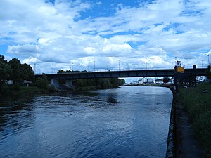
| Southern section of the Nibelungen Bridge , on the left the southern bank of the Unteren Wöhrd | ||
The Untere Wöhrd (formerly also Unteres Wehr ) is a populated river island in the Danube in the urban area of the German city of Regensburg . The island is the eastern of the two large Danube islands in the urban area of Regensburg.
Location and connection
The two islands "Oberer Wöhrd" and "Unterer Wöhrd" in the urban area of Regensburg lie between river kilometers 2,381.3 and 2,377.8 of the Danube. The Untere Wöhrd is the eastern part of the islands and extends from the Stone Bridge to the Lazarettspitze , where the rain and the two arms of the Danube unite. In the development of the current river system with the two branches of the Danube and the two Danube islands, the Regen river, the Naab and - as expected - the Danube in particular played a role . The Lower Wöhrd was created at the time when the Roman legion camp Castra Regina was built in the 2nd century , while the Upper Wöhrd was not built until shortly after 1300. Details of the development of the river-island system are described in detail in the Obere Wöhrd .
With an area of around 28 hectares and a length of around 1.8 km, the Untere Wöhrd is the smaller of the two Danube islands. The island is home to around 1200 inhabitants (as of 2013). The traffic connection to Regensburg's old town is via the Iron Bridge . In the east, the island is connected to the northern suburbs via a driveway to the Nibelungen Bridge. The so-called Grieser Steg , a pedestrian and bicycle bridge over the Mühlkanal and the northern arm of the Danube, creates the connection to the Stadtamhof district . The stone dam stabilized at the side with piles anchored in the river bed - called Beschlächt - crosses under the stone bridge and has been connecting the two Danube islands since 1388. When the water level is normal, the Steindamm is passable for pedestrians in both directions and is an attractive connection between Badstrasse on the Obere Wöhrd and Wöhrdstrasse on the Untere Wöhrd with spectacular views of the old town of Regensburg.
Use and settlement
Although the Untere Wöhrd was outside the city walls of Regensburg, it was still an important part of the urban fabric and was shaped early on by the settlement of fishermen and boatmen. From 1550 cattle pastures, businesses and facilities were settled on the Unteren Wöhrd that were undesirable in the urban area or required a lot of space, for example brick and lime kilns and a large area for bleaching the laundry, which is also shown on the city map from 1700.
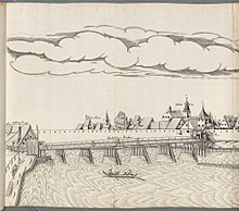
These uses made it necessary to connect the island to the city via a wooden bridge, the base of which on the city side comes close to the base of today's Iron Bridge. The maintenance of the bridge was costly because it was often damaged by floods and ice drifts and destroyed in the course of the fighting for Regensburg during the Thirty Years' War.
On the island, the wood and logs required for building and heating were prepared and shod and stored together with the tools in several warehouses. The busy workers also had their huts nearby. The Untere Wöhrd was also suitable as a storage area to accommodate troops passing through and to isolate people with infectious diseases. On the eastern part of the island - the so-called Lazarett-Spitz - a plague hospital was built, which was last used during the plague epidemic in 1713, but its buildings are still preserved today.
Around 1800 some garden houses and tree avenues were built on the island, which were warmly recommended by the ambassadors at the Perpetual Reichstag as destinations for quiet walks. With the settlement of a shipyard and a machine factory, however, there was also increasing industrialization. Shipping companies also use the island for embarking passengers to Passau, Vienna and Budapest. In 1856 a large harbor basin was completed at the level of the Royal Villa on the north bank of the Danube and used as a winter harbor. The structural evidence of the industrial activities of the 19th century has now been completely lost. The basin of the winter harbor was also filled with rubble after the Second World War and is now used as a large car park. The youth hostel was only built in 1938 after the Nibelungen Bridge had been built and the lower Wöhrd was connected to the urban road network.
See also
Web links
literature
Klaus Heilmeier: A desert island and more of a village than a suburb. Searching for traces on the Untere Wöhrd , published by the City of Regensburg Office for Archives and Preservation of Monuments, Preservation of Monuments in Regensburg, Volume 13, Verlag Friedrich Pustet, Regensburg 2014, ISBN 978-3-7917-2550-5 , pp. 100-175
Individual evidence
- ^ A b Karl Bauer: Regensburg Art, Culture and Everyday History . 6th edition. MZ-Buchverlag in H. Gietl Verlag & Publication Service GmbH, Regenstauf 2014, ISBN 978-3-86646-300-4 , p. 451 f .
- ^ Karl Bauer: Regensburg art, culture and everyday history . MZ Buchverlag, Regensburg 2014, ISBN 978-3-86646-300-4 . Pp. 462, 886-892
- ↑ Klaus Heilmeier: A desert island and more of a village than a suburb. Searching for traces on the Untere Wöhrd . In: City of Regensburg, Office for Archives and Preservation of Monuments (ed.): Preservation of monuments in Regensburg . tape 13 . Friedrich Pustet, Regensburg 2014, ISBN 978-3-7917-2550-5 , pp. 103-110 .


