
Uttarakhand

|
|
| status | State |
| Capital | Dehradun |
| founding | November 9, 2000 |
| surface | 53,483 km² |
| Residents | 10,086,292 (2011) |
| Population density | 189 inhabitants per km² |
| languages | Hindi |
| governor | Baby Rani Maurya |
| Chief Minister | Trivendra Singh Rawat ( BJP ) |
| Website | gov.ua.nic.in |
| ISO code | IN-UT |
 .svg) |
|
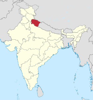
Uttarakhand ( Hindi उत्तराखण्ड Uttarākhanḍ [ ʊttʌrɑːkʰʌɳɖ ]), until December 31, 2006 Uttaranchal (Hindi उत्तरांचल Uttarāncal [ ʊttʌrɑːnʧʌl ]), is an Indian state with an area of 53,483 square kilometers and about 10.1 million inhabitants (2011 census). It was founded in 2000 by splitting off from Uttar Pradesh . The interim capital of Uttarakhand is Dehradun , the official language is Hindi. The name Uttarakhand comes from Sanskrit and, like the old name Uttaranchal, means "northern region".
geography

Uttarakhand is located in the Himalayas in northern India. Neighboring states are Uttar Pradesh in the south and Himachal Pradesh in the northwest. In the northeast lies the border with Tibet ( People's Republic of China ), in the east with Nepal . With an area of 53,484 square kilometers, Uttaranchal is slightly larger than the German state of Lower Saxony .
The Uttarakhand terrain extends from the Ganges plain in the south over the foothills of the Himalayas to the high mountains with the Nanda Devi (7816 m), the highest mountain in India lying entirely on its territory. The state of Uttarakhand consists of the two mountain regions Garhwal in the west and Kumaon in the east, as well as a narrow strip of the Ganges plain in the south. In the mountains of Garhwal are the holy springs of the two rivers Ganges and Yamuna .
population
Demographics

According to the 2011 Indian census, Uttarakhand has 10,086,292 inhabitants. In terms of population, Uttarakhand ranks 20th among the 29 states of India. Between 2001 and 2011, the population grew by 19 percent and thus little faster than the national average (18 percent). Because of the mountainous terrain, Uttarakhand is very sparsely populated: The population density with 189 inhabitants per square kilometer is only half of the overall Indian average of 382 inhabitants per square kilometer. The population is very unevenly distributed: While 801 people live in one square kilometer in the Haridwar district in the Ganges plain, there are only 41 in the high mountains in the Uttarkashi district . Most of Uttarakhand's population lives in the countryside: the degree of urbanization is 30 percent and thus corresponds almost exactly to the national average of 31 percent. The gender ratio is slightly less unbalanced than the national average: for every 1,000 men in Uttarakhand there are 963 women, while the corresponding value for India as a whole is 943. Among the 0 to 6 year olds, the gender ratio is 890 but below the Indian average of 919.
79 percent of Uttarakhand's residents can read and write (men: 87 percent, women: 70 percent). The literacy rate is thus above the Indian average of 73 percent.
In the mountain valleys of the north there are numerous microcivilizations with their own languages and cultures. The religion of the high mountain dwellers, who until the border was closed were more oriented towards Tibet than towards the south, is strongly influenced by Buddhism , but also contains Hindu elements. In the low mountain range mainly members of the higher castes of the Brahmins and Rajputs live . After India's independence in 1947, immigrants from Bengal and the Panjab settled on the plain, and they managed to acquire some real estate over the years.
languages
| Languages in Uttarakhand | ||||
|---|---|---|---|---|
| language | percent | |||
| Hindi | 88.0% | |||
| Urdu | 5.9% | |||
| Punjabi | 2.9% | |||
| Bengali | 1.5% | |||
| Nepali | 1.1% | |||
| Other | 0.6% | |||
| Distribution of languages (2001 census) | ||||
The main language of Uttarakhand is Hindi , the largest language in India. According to the 2001 census, 88 percent of the state's population speak Hindi as their first language. This also includes the speakers of the Kumaoni and Garhwali . These regional languages belong to a group of dialects widespread in the Himalayan region, which are summarized under the term Pahari . Linguistically, the Pahari dialects differ sufficiently from standard Hindi to be classified as separate languages. Nevertheless, the standard Hindi is the official and educational language in Uttarakhand and serves as the umbrella language for the Pahari dialects. In official statistics, the Pahari dialects are included in Hindi. In total, the 2001 census recorded around 2.2 million Garhwali speakers and 2 million Kumaoni speakers.
Among the Muslims of Uttarakhand, Urdu , the Muslim variant of Hindi, is widespread with just under 6 percent. Due to immigration, there are smaller numbers of speakers of other languages such as Punjabi (2.9 percent), Bengali (1.5 percent) and Nepali (1.1 percent). As in all of India, English is widely used as a lingua franca and education.
Religions
| Religions in Uttarakhand | ||||
|---|---|---|---|---|
| religion | percent | |||
| Hinduism | 83.0% | |||
| Islam | 13.9% | |||
| Sikhism | 2.3% | |||
| Other | 0.8% | |||
| Distribution of religions (2011 census) | ||||
According to the 2011 census , Hindus make up the vast majority of the inhabitants of Uttarakhand with 83 percent. The mountain regions of Uttarakhand in particular are almost entirely Hindu. A larger Muslim minority also lives in the lowlands . Overall, Muslims make up 14 percent of the state's population. There is also a smaller minority of Sikhs (a little over 2 percent), who are mainly concentrated in the Udham Singh Nagar district .
Largest agglomerations
Anglicized, outdated or unofficial names are in brackets. The population figures are at the level of the 2011 census.
| city | Residents | city | Residents | ||
|---|---|---|---|---|---|
| 1 | Dehradun | 706.124 | 6th | Kashipur | 121,623 |
| 2 | Haridwar | 310.796 | 7th | Rishikesh | 102,469 |
| 3 | Rurki (Roorkee) | 238,422 | 8th | Pithoragarh | 56,044 |
| 4th | Haldwani | 232.095 | 9 | Ramnagar | 54,787 |
| 5 | Rudrapur | 154,554 | 10 | Kichha | 53,357 |
politics
Political system
The legislature of the state of Uttarakhand consists of a unicameral parliament , the Uttarakhand Legislative Assembly . Seventy members of parliament are elected by direct election every five years . Another MP is appointed by the governor to represent the Anglo-Indian minority. The parliament has its seat in Dehradun . Uttarakhand has five MPs in the Lok Sabha , the lower house of the Indian parliament, and three in the Rajya Sabha , the Indian upper house.
The Chief Minister (Head of Government) Uttarakhands, is elected by Parliament. But is appointed by the President of India Governor (at the head of the State Governor ). Its main tasks are to appoint the Chief Minister and to entrust him with the formation of the government.
The highest court in Uttarakhand is the Uttarakhand High Court , based in Nainital .
Parties
| Distribution of seats after the 2017 parliamentary elections |
|
|---|---|
| BJP | 57 |
| congress | 11 |
| Independent | 2 |
| Anglo-Indians | 1 |
| total | 71 |
The strongest parties in Uttarakhand are the Indian National Congress and the Hindu nationalist Bharatiya Janata Party (BJP). In the 2012 general election, the Congress Party won 32 constituencies and the BJP 31 constituencies. Also represented in parliament are three MPs from the Bahujan Samaj Party (BSP), which has its supporters mainly among the Dalits (casteless), one MP from the regional party Uttarakhand Kranti Dal (UKD) and three independents. After the election, the Congress Party was able to secure a parliamentary majority with the support of the three independent MPs and the MP from Uttarakhand Kranti Dal. Harish Rawat of the Congress Party then became Chief Minister . The parliamentary election on February 15, 2017, on the other hand, was clearly won by the BJP. Trivendra Singh Rawat (BJP) has been Chief Minister of Uttarakhand since March 18, 2017 .
Administrative division

Uttarakhand is divided into two divisions and 13 districts . The Garhwal division includes the districts of Dehradun, Haridwar, Tehri Garhwal, Uttarkashi, Chamoli, Pauri Garhwal, and Rudraprayag, while the Kumaon division includes the districts of Almora, Bageshwar, Champawat, Nainital, Pithoragarh, and Udham Singh Nagar.
Uttarakhand districts (data from 2011 census):
| District | Administrative headquarters | surface | Population (2011) |
Population density |
|
|---|---|---|---|---|---|
| 1 | Uttarkashi | Uttarkashi | 8,016 km² | 330.086 | 41 people / km² |
| 2 | Chamoli | Gopeshwar | 8,030 km² | 391,605 | 49 inhabitants / km² |
| 3 | Rudraprayag | Rudraprayag | 1,984 km² | 242,285 | 122 inhabitants / km² |
| 4th | Tehri Garhwal | New Tehri | 3,642 km² | 618.931 | 170 people / km² |
| 5 | Dehradun | Dehradun | 3,088 km² | 1,696,694 | 549 inhabitants / km² |
| 6th | Pauri Garhwal | Pauri | 5,329 km² | 687.271 | 129 inhabitants / km² |
| 7th | Pithoragarh | Pithoragarh | 7,090 km² | 483,439 | 68 inhabitants / km² |
| 8th | Bageshwar | Bageshwar | 2,241 km² | 259,898 | 116 inhabitants / km² |
| 9 | Almora | Almora | 3,144 km² | 622.506 | 198 inhabitants / km² |
| 10 | Champawat | Champawat | 1,766 km² | 259,648 | 147 inhabitants / km² |
| 11 | Nainital | Nainital | 4,251 km² | 954.605 | 225 inhabitants / km² |
| 12 | Udham Singh Nagar | Rudrapur | 2,542 km² | 1,648,902 | 649 inhabitants / km² |
| 13 | Haridwar | Haridwar | 2,360 km² | 1,890,422 | 801 inhabitants / km² |
economy
The population of Uttarakhand lives mainly from agriculture . Especially in higher regions, the yields are only sufficient to cover their own needs. There are millet , vegetables , potatoes , apples , and at lower altitudes and rice grown. Tourism is an important source of income . Above all Indian pilgrims , but also Western tourists, visit the holy places Rishikesh and Haridwar , as well as the temples known as Chota Char Dham in Badrinath , Kedarnath , Yamunotri and Gangotri . Mountain resorts founded by the British , such as Masuri ( Mussoorie ) or Nainital, offer refuge from the heat of the plains to wealthier Indians in summer.
With a value of 0.662, Uttarakhand ranks 13th among the 29 states of India in the Human Development Index in 2015 .
Culture

In contrast to the rest of India, Brahmins and Rajputs form the upper main castes in Uttarakhand . The name of the Rajput caste, otherwise called Kshatriya , refers to the historical connection between the groups belonging to it and western India ( Rajputana ). According to an estimate, the number of members of the low-caste Shilpkars, which are also on the lower edge in economic terms, is only about a tenth as large as these two castes combined. The Shilpkars are made up of several professional castes, which are clearly delineated by their activities. While all social classes perform dances on the occasion of festive events - mostly within related caste groups - the professional instrumentalists of traditional folk music belong to fixed music caste. Among them, the Bajgis (also Auji) form the largest group. The Bajgis are responsible for the musical instruments played at outdoor ceremonial events such as private weddings and public annual religious festivals. A drum pair consisting of the large barrel drum dhol and the small kettle drum damau is always required for such events . Two bagpipes mashak are usually used as melody instruments at village weddings . In their place or in addition, brass bands belonging to urban light music are occasionally engaged. The curved natural trumpet ranshringa and sometimes the straight long trumpet bhankora have a ceremonial function, also in religious rituals .
The Beda (also Baddi) form a second, smaller caste of musicians with a decline in importance. Its members have specialized in traditional light music, which is mainly played on the smaller barrel drums dholak (or dholki ) and the Indian harmonium . Beda also work as acrobats and other entertainers. In a dramatic event in honor of the goddess Devi that goes back to a religious sacrificial ritual, a Beda slides down a long rope from a hill into a ravine.
There are also professional musicians who do not belong to any particular music class, but who perform at ceremonies in closed rooms (private houses). Typical of the region are possession ceremonies ( jagar ), in which a deity is invoked to temporarily take possession of a person dancing in the midst of the crowd. The leader of the ceremony recites sacred texts and at the same time plays the hourglass drum daunr or the similar drum hurka , while his companion beats the brass plate thali .
Other musical instruments that are widespread in northern Indian folk music and used in the regional styles of Uttarakhand are the frame drum with a bell ring khanjari , the large kettle drum nagara ( nageri , see nagra ), the snail horn , the double wind instruments pungi and algoja , the stringed instruments ektara and sarangi as well as kartal and chimta as stroke idiophones .
The rich folk literature that has been handed down orally and in writing includes above all adaptations of the Sanskrit epic Mahabharata and stories about Hindu gods such as Nirankar, a regional form of Shiva . Pandavalila is a theater play that takes place on a free place ( mandap ) at major annual festivals , in which an episode from the fight between the five Pandava brothers and the opposing Kauravas is staged in the Mahabharata . Other popular theater pieces are Ramlila , Krishnalila (about the youthful Krishna ), Satya Harishchandra (about the mythical King Harishchandra ), Bhakta Prahalad (about the demon Prahlada ), which are often performed in the genres of nautanki and swang . Pattar is a game with dances, songs, music and masked actors.
The traditional forms of singing are divided into long epic ballads ( gatha ) and shorter folk songs ( lok-git ). Pawada (in Maharashtra powada ) are heroic songs that deal with the bravery and courage of previous kings.
The most famous popular music singer from the Garhwal region is Narendra Singh Negi (* 1949). Mohan Upreti (1928–1997) from Kumaon was known as a theater director, composer and folk song singer. Other popular singers from Uttarakhand are Chander Singh Rahi (1942-2016), the jagar singer Basanti Devi Bisht (* 1953) and Heera Singh Rana.

literature
- Gopal Bhagarva: Encyclopaedia Of Art And Culture In India (Uttarakhand) . Vol. 13, Isha Books, Delhi 2008 ( online at Internet Archive )
Web links
- Directory of official government sites in India - Uttarakhand (English)
- Country portrait of Uttarakhand by Torsten Otto at suedasien.info
- Photo series about Uttarakhand by Christoph S. Sprung and Uwe Skoda at suedasien.info
- News about the change of government in Uttarakhand (March 2007) at suedasien.info
Individual evidence
- ↑ New name from January 1, 2007: Uttaranchal is Uttarakhand, BJP cries foul - The Times of India
- ^ Know India: Uttarakhand
- ^ Census of India 2011: Primary Census Data Highlights - India. Chapter 1 (Population, Size and Decadal Change) (PDF; 9.2 MB).
- ^ Census of India 2011: Primary Census Data Highlights - India. Chapter 3 (Literates and Literacy Rate) (PDF; 2.7 MB).
- ^ Census of India 2001: Statement - 3 Distribution of 10,000 Persons by Language - India, States and Union Territories - 2001 and Distribution of the 100 Non-Scheduled Languages-India / States / Union Territories .
- ^ Census of India 2001: Abstract of Speakers' Strength of Languages and Mother Tongues . ( Memento from October 29, 2013 in the Internet Archive )
- ↑ Census of India 2011: Population by religious community.
- ↑ Census of India 2001: Population, population in the age group 0-6 and literates by sex - Cities / Towns (in alphabetic order) ( Memento from June 16, 2004 in the Internet Archive )
- ↑ Uttarākhand / Uttaranchal (India): State, Agglomerations & Cities - Population Statistics, Maps, Graphics, Weather and Web Information. Retrieved December 29, 2018 .
- ^ Election Commission of India.
- ↑ Uttar Pradesh Punjab Goa Manipur. livemint.com, March 11, 2017, accessed March 12, 2017 .
- ↑ Census of India 2011: Primary Census Abstract - Uttarakhand. (PDF; 482 kB)
- ^ Sub-national HDI - Area Database - Global Data Lab. Retrieved August 12, 2018 .
- ^ Andrew Alter: Dancing with Devtās: Drums, Power and Possession in the Music of Garhwal, North India. (2008) Routledge, Abingdon / New York 2016, p. 39f
- ↑ Bhunda narmedh mahayajna - Yash RazZ Creations. Youtube video ( rope-sliding ceremony in Bhunda, which takes place there every twelve years)
- ↑ Gopal Bhagarva, 2008, p. 148
- ^ Anoop Chandola: Folk Drumming in the Himalayas. A Linguistic Approach to Music . AMS Press, New York 1977, p. 18
- ↑ Gopal Bhagarva, 2008, pp 132, 135
- ↑ Gopal Bhagarva, 2008, p. 147
| Today's states |
Andhra Pradesh • Arunachal Pradesh • Assam • Bihar • Chhattisgarh • Goa • Gujarat • Haryana • Himachal Pradesh • Jharkhand • Karnataka • Kerala • Madhya Pradesh • Maharashtra • Manipur • Meghalaya • Mizoram • Nagaland • Odisha • Punjab • Rajasthan • Sikkim • Tamil Nadu • Telangana • Tripura • Uttarakhand • Uttar Pradesh • West Bengal |
|
| Union Territories |
Andaman and Nicobar Islands • Chandigarh • Dadra and Nagar Haveli and Daman and Diu • Delhi • Jammu and Kashmir • Ladakh • Lakshadweep • Puducherry |
|
| Former states |
Ajmer • Andhra • Bhopal • Bilaspur • Bombay • Coorg • Hyderabad • Jammu and Kashmir • Kachchh • Madhya Bharat • Mysore • Patiala and East Punjab States Union • Saurashtra • Travancore-Cochin • Vindhya Pradesh |
Coordinates: 30 ° 18 ' N , 79 ° 0' E