
Wurgwitz
|
Wurgwitz
Large district town of Freital
Coordinates: 51 ° 1 ′ 31 ″ N , 13 ° 37 ′ 40 ″ E
|
|
|---|---|
| Height : | 259–308 m above sea level NHN |
| Area : | 4.82 km² |
| Residents : | 2495 (Dec. 31, 2017) |
| Population density : | 518 inhabitants / km² |
| Incorporation : | 1st January 1974 |
| Postal code : | 01705 |
| Area code : | 0351 |
  Location of the districts Niederhermsdorf, Wurgwitz and Kohlsdorf within the district of Wurgwitz and the city of Freital
|
|
 Map of the district with traffic routes and some important points (click to enlarge)
|
|
_-_geo.hlipp.de_-_9967.jpg)
Wurgwitz is a district of the Saxon large district town of Freital in the district of Saxon Switzerland-Eastern Ore Mountains . It is located in the northwest of the urban area and consists of the three districts Wurgwitz, Niederhermsdorf and Kohlsdorf . The predominantly rural Wurgwitz has about 2600 inhabitants. With its location in the Dresden metropolitan area , the place is only a few kilometers away from the city center of Dresden .
The place was first mentioned in a document in 1206 in connection with the dispute over Thorun Castle on the nearby Burgwartsberg , as well as Wurgwitz, Potschappel and Dresden. Wurgwitz was an independent municipality until January 1, 1974, which was then incorporated into the city of Freital. Currently, one of the four local councils in the district is elected.
geography
Geographical location

Wurgwitz is Freitals most northwestern part of the city and borders in the north on the corridors of the city of Wilsdruff and the state capital Dresden, where the Döhlen basin is separated from the Saxon loess loam area by partly steep mountain ridges . The landscape is determined by the valleys formed by the Wiederitz and Hammerbach rivers, which significantly influence the relief on the northwestern edge of the Döhlen basin.
The Wurgwitz corridors consist of meadows, fallow land, a few hectares of arable land, partially abandoned fruit trees and settlement areas with allotment gardens. There is a mixed forest of hornbeam and oak on the slopes of the valley along the roads in the direction of Kesselsdorf and Oberhermsdorf . Due to the fact that the southern slopes heat up strongly in summer and the climate is very stable, wine was previously grown in Wurgwitz . With the appearance of phylloxera around 1900, however, viticulture had to be given up.
The Wiederitz , a left tributary of the Weißeritz , flows through Wurgwitz along the road from Kesselsdorf to Potschappel. The Hammerbach rises to the west of Old Franconia , near the A17 . It flows between Kohlsdorf and Wurgwitz in a south-easterly direction; below the Hammersiedlung it is dammed up to become the Hammerteich . In Zauckerode it flows into the Wiederitz. The Oberhermsdorfer Bach rises in the Wilsdruffer district of Oberhermsdorf and then flows through the village center of Niederhermsdorf into the Wiederitz. Coming from the west of Kleinopitz , the Quänebach cuts the Wurgwitz corridors, feeds the Zacke outdoor pool in the Zauckerode district and shortly afterwards also flows into the Wiederitz.
Neighboring places and subdivisions

The Wurgwitz district of Freital is made up of three districts . Niederhermsdorf forms the southwest of the district and is characterized by extensive arable and pasture areas, especially in the direction of Kleinopitz. The Wurgwitz district essentially extends over the slope to the left of the Wiederitz and to the right of the Hammerbach, with the southern part of the district being built up quite densely. In the north there is again grass and pasture areas. Kohlsdorf as the third suburb is located east of Wurgwitz and is the most sparsely populated. Only along Pennricher Strasse and Hohen Strasse are more dense residential buildings that were built in the 1930s. Gut Hammer is also part of Kohlsdorf , so the few houses there are also known as "Hammersiedlung" or "Hammer-Wurgwitz". The desolate settlement of Bulsitz is believed to be located on the river Wiederitz between Niederhermsdorf and Kesselsdorf .
The surrounding area is quite densely populated, so that some of the towns merge into one another, such as Zauckerode to the south-east, also a district of Freital. On the border between the two places, a new housing estate was built in the 1990s, which since then no longer shows any recognizable landscape demarcation between the villages. The built-up areas also merge seamlessly along Kesselsdorfer / Wilsdruffer Straße. This is less clear in the small distant places Niederhermsdorf and Oberhermsdorf, to the west of it.
Wurgwitz borders the Wilsdruffer districts of Kesselsdorf in the northwest and Kleinopitz in the southwest. While a state road leads to Kesselsdorf, Kleinopitz and the Saalhausen district to the south cannot be reached by motor vehicles from Wurgwitz. To the east, Pesterwitz adjoins the Kohlsdorf district, between the two locations Gut Pesterwitz has been growing wine again on Kohlsdorfer Flur since the 1980s. Old Franconia , located in the northeast, like Pennrich and Zöllmen, is already part of Dresden.
history
First mention, late Middle Ages and early modern times

At the end of the 12th century, German influence continued to expand in the areas populated by Slavs. The Dohna burgrave Heinrich had Thorun Castle built at this time . Their position is not exactly proven, but based on excavation findings it is assumed that the fort must have been on the Burgwartsberg near Pesterwitz. The cathedral chapter of Meissen saw the establishment of a violation of its sovereign territory and requested Pope Innocent III. to reverse the construction. The margrave of the Gau Nisan , Dietrich the distressed, was obliged to settle the dispute . He ordered a border inspection to clarify the issue, to which the owners of the surrounding villages were invited. Among them "Hermannus de Worganewicz" was mentioned, the owner of today's Wurgwitz. His name is handed down in the margrave's final certificate, written in 1206, which awarded the area between the source of the Wiederitz (Zuchewidre) and its confluence with the Weißeritz (Bistrice) to the Meißner Hochstift . Thorun Castle was then razed. On behalf of the Meißner bishop, Hermann had undertaken a small attempt to expand the country in a westerly direction, where Nieder- and Oberhermsdorf emerged (named after him); The Burgraves of Dohna, who also colonized nearby and were put in their place in 1206, prevented a more comprehensive success. The lords of Wurgwitz can be traced back to the episcopal court until 1228, their descendants until at least the 15th century.
In the document located in the main state archive in Dresden, Dresden, Döhlen , Potschappel and Gompitz are also mentioned for the first time. Kohlsdorf was first mentioned in 1450 as "Colostorff", Niederhermsdorf appeared in 1381 as "Nydern Hermansdorf" for the first time in written documents.
In the time of Hermannus de Worganewicz, Wurgwitz only consisted of a few small houses and three-sided courtyards , which were lined up along today's Zöllmener Straße, Wiesenweg and Am Weinberg street in the style of a lane village. The location on the slope provided a good overview of the Döhlen basin in the south, which was an advantage from a strategic point of view. The word ending -ovici means “settlement of the people” or “village of the clan” in Slavonic. The likely Slavic place name Vrganovici therefore probably comes from the settlement of the people of a Vrogan.

For the year 1303 the naming of "Wrganewytz" is handed down, 1308 that of "Wrganuwicz". "Worgenwicz" and "Worgenewicz" are mentioned in documents from 1378. In the middle of the 15th century, “Worgewicz”, later also “Wurgenwicz”, appeared as a place name. From the year 1539 "Wurgewitz" was handed down, in 1547 the village was also called "Worgitz". At that time there were 15 residents and 13 “possessed men” in the place who farmed 6 1 ⁄ 2 Hufen of land.
A summer linden tree was planted at the entrance to the Wurgwitz manor in 1625 on the occasion of the 100th anniversary of the Peace of Augsburg . It is still right on Zöllmener Straße and is protected as a natural monument. In a document from 1645, 16 charitable Wurgwitzer were listed by name. During the plague wave in 1680, 36 people died in Kesselsdorf and Wurgwitz. In December 1745 an army of Austrians and Saxons was defeated by the Prussian army in the battle of Kesselsdorf just a few kilometers from the village. After the end of the Seven Years' War (1756–1763), which had financial repercussions on Wurgwitz, nine possessed men and five cottagers lived in the village, they cultivated eight Hufen land of 13 bushels each. Also mentioned were five “desert” possessed men and five cottagers. At the beginning of the 17th century, Christian Gottlieb Brendel acquired the Wurgwitzer manor with jurisdiction over the place. During the German War in 1866 Prussian soldiers were stationed in Wurgwitz.
Wurgwitz under the sign of hard coal mining
The exact start of coal mining in the Döhlen basin is not documented. It is assumed that as early as the 12th century there was isolated extraction of hard coal by farmers living in the region at that time. At the Weißeritz, Hans Biener received the documented mining privilege on hard coal from the Saxon Duke Moritz in 1542 . A legend tells about the discovery of hard coal in the Döhlen Basin of a shepherd who is said to have piled stones up near Kohlsdorf to protect them from the wind in the 15th or early 16th century:
“On a rough autumn day, a shepherd lit a fire in the field near the village of Kohlsdorf to warm himself. The wind kept putting out the fire. He gathered a lot of stones to build a protective wall against the wind. There were many blacks among the stones that the horse had scratched out with its hoof. He was shocked to see that the black stones of the wall were on fire. This is how the coal was discovered. "
Favored by the hillside location of Wurgwitz, the coal seams running parallel to the surface could occasionally come to light. It is therefore likely that the Wurgwitzer farmers used simple means to mine “horizontally” coal earlier. Hard coal mining in Kohlsdorf has been handed down to landowner Georg Brendel in 1574. The first sinking of coal pits took place in Wurgwitz in the 17th and 18th centuries. The location of these first subsidies was the area around the former Wurgwitzer Kleinbahnhof. Hard coal quickly became the basis for many craft businesses, and from 1736 it was also used as firing material in Saxon silver mining . The demand for coal continued to rise and exceeded the capacity of the previously around 30 small shafts that stretched between Kohlsdorf and Burgwartsberg in 1785. Between today's Zöllmener and Kesselsdorfer Strasse there were a number of other pits that were part of the “Brendel mining fields”. In 1786 a hard coal mine was opened in Niederhermsdorf. From 1800 to 1842 the deep Weißeritz tunnel was created to drain the pit. With the Tiefen Elbstolln , begun in 1817 and completed in 1837, the water could also be diverted from deeper shafts.
Mining in the Wurgwitzer area also opened up traffic. In 1821, today's Kesselsdorfer Straße was expanded to resemble a lake and used as a coal road to transport the hard coal from the Freitaler Revier in the direction of Freiberg . The expansion measure was part of a comprehensive road construction program to develop the country. On December 1, 1856, the standard gauge Niederhermsdorf coal branch line went into operation from the Potschappel station to the Albertschacht. The inauguration of the Freital-Potschappel-Nossen narrow-gauge railway followed on October 1, 1886. It used the track of the coal branch line between Potschappel and Wurgwitz ( three- rail track ). The narrow-gauge line was also used to transport people. The Wurgwitz bridge over Kesselsdorfer Straße was the first in Europe to be built using a trestle construction .
Around 1840 there were ten shafts in the Kohlsdorf district, in which around 100 miners were employed. These systems were only a maximum of 66 meters deep and were used to mine coal seams between four and twelve meters thick. In 1843 Carl Friedrich August Freiherr Dathe von Burgk bought the Kohlsdorf estate, whose mining fields were now operated by the Freiherr von Burgker coal and ironworks . Production was quickly shut down, although coal could still have been mined. In 1862 all coal pits were closed with the exception of the Gotthard shaft. A revival of coal mining in Kohlsdorf after 1945 was abandoned after preliminary investigations.
The shafts between Kesselsdorfer and Zöllmener Strasse were operated by the Brendel coal works founded in 1820. The largest of the shafts there was the Albertschacht , in operation from 1835 to 1922, in the area of today's timber trade. A street name on the site and the Wurgwitz primary school, which was named Am Albertschacht in 2004, are reminiscent of the mine, which was sunk to a depth of 204 meters . The last hunt left the Albertschacht on October 31, 1922. After the end of mining at this point, most of the buildings were demolished in 1922–1923, only the old machine house is still preserved. Coal was mined at light hole 21 of the Tiefen Weißeritz tunnel until 1952. The light hole was made in 1841 to improve the ventilation of the Albertschacht. From 1935 there was a wooden winding tower there, which was demolished after the dismantling stopped.
Empire and Weimar Republic
| year | Residents |
|---|---|
| 1828 | 150 |
| 1834 | 192 |
| 1840 | 203 |
| 1867 | 323 |
| 1871 | 389 |
| 1880 | 452 |
| 1890 | 550 |
| 1910 | 1056 |
| 1921 | 1026 |
| 1925 | 2065 |
| 1928 | 2242 |
| 1933 | 2367 |
| 1939 | 2751 |
| 1946 | 2885 |
| 1950 | 2966 |
| 1964 | 2569 |
| 1990 | 1770 |
| 2000 | 2417 |
| 2010 | 2462 |
| 2015 | 2578 |
| 2017 | 2495 |

The first post office opened in Niederhermsdorf in 1889, previously there had been a post office since April 1, 1888. The first water pipes had existed in Niederhermsdorf since 1898. On July 15, 1908, the new school in Wurgwitz was inaugurated because the capacity of the first Wurgwitz school , built in 1873, was no longer sufficient due to the increase in population. 56 Wurgwitzer and Niederhermsdorfers lost their lives during the First World War . In 1934 the unemployed erected a monument to their memory, which still exists today and was dedicated to the “ Memorial to the Victims of War and Tyranny ” after the Second World War .
At the end of the First World War, most of the municipalities were financially weak. More efficient communities were required to get the economy going again. First, a merger of Wurgwitz and Niederhermsdorf with Zauckerode and Saalhausen was considered. However, an agreement could not be reached with Zauckerode and Saalhausen, and so on July 7, 1921 only the two communities Niederhermsdorf and Wurgwitz merged. The municipal administrations initially favored "Kohlsdorf" as the name for the new municipality, but the Interior Ministry criticized the proposal with reference to the already frequently existing place name Kohlsdorf and the historical significance and uniqueness of the name Wurgwitz. As an alternative, the name of the actually smaller municipality of Wurgwitz was adopted compared to Niederhermsdorf. With the political amalgamation of the places, the fire brigade, local poor, registry office and school districts also united. First of all, the municipal councils of both places were merged, until the end of 1921 there was a new election of a twelve-member municipal council. The new local law determined the former Wurgwitz community leader Walther Zwingenberger to be the first leader of the united community. He was mayor until mid-1945.
A free field between the new school and the remaining residential buildings on Pesterwitzer Strasse was chosen as the location for the new town hall of the community. The building planned by the Dresden architect Alfred Grummt was erected here in 1925 for around 100,000 Reichsmarks . Mining and the expansion of industry in the Döhlen basin also had an impact on the surrounding villages. Settlements of workers' houses emerged, for example along the Pesterwitzer and Rudolf-Breitscheid-Strasse in 1930 and on the Kohlsdorf slope of the Hammerbach in 1936. As a result, the social democratic culture found its way into village life, workers' associations such as “United Turner and Singer Wurgwitz” and today's SG Wurgwitz, founded in 1922, came into being. A few hundred meters southwest of the town hall, the members of the gymnastics and singers' club Wurgwitz built a sports hall in 1928, today's Alfred-Damm-Heim .
Of the 2065 inhabitants in 1925, 1682 were Evangelical Lutheran , 24 Catholic and 359 of other or no denominations.
National Socialism and the GDR era
On May 19, 1933, the first meeting of the Wurgwitz municipal council took place under the leadership of the National Socialists . As a result, among other things, the sports grounds and club property were expropriated in 1935, further use for this purpose was prohibited. On the narrow gauge railway bridge over the Kesselsdorfer road occurred a 1935 train accident : a freight train broke on the bridge and got wedged. There were no serious injuries. In the Second World War from 1939 to 1945 around 170 men were killed in Wurgwitz, but the exact number of those killed could never be determined. In April, the pilot was killed in Niederhermsdorf when an airplane crashed. On May 8, 1945 the first soldiers of the Red Army reached Wurgwitz. Hardly anyone complied with the previous request to flee from the Soviet troops. The capture of the place went without incident.
Mayors of Wurgwitz after 1945 were (chronological; term of office in brackets, if known):
- Mr. Nagel
- Mr. Bock
- Hans executioner
- Walter Daehn (1959–1972), later mayor of Freital
- Karl-Heinz Hofmann (1972–1973)
In the GDR, Wurgwitzer agriculture was reorganized according to the principle of socialist agriculture . The landowners were evicted, so in 1953 the manor Winkler had to flee to the west. The agricultural areas were nationalized and on July 10, 1954 to LPG type III “8. March “united. In 1960 two LPG Type I were founded from the remaining private farms. They were in the LPG “8. March "transferred.
In the sports area, the sports club was allowed to use the hall again, although it remained the property of the Wurgwitz community. Under the sponsorship of the Deutsche Reichsbahn , the BSG Lokomotive Wurgwitz took part in regional competitions in football, gymnastics, handball and billiards from 1962 under this name. In 1979 local residents built a ski lift on their own initiative on the slope along what is now Oberhermsdorfer Straße. In the same winter it was ready for use and from then on it was operated by the ski department of the BSG.
Due to the increasing motorization of goods and passenger traffic, the last train on the narrow-gauge line from Wilsdruff to Potschappel drove on May 27, 1972 after 86 years of operation. The more flexible bus transport had made rail transport superfluous. Initial efforts to establish a bus route from Dresden via Kesselsdorf and Wurgwitz to Oberhermsdorf had already been made at the end of the 1920s. The station building on the narrow-gauge railway line has been used by the Wurgwitz volunteer fire department as a fire station since it was closed . After a voluntary renovation, the fire brigade moved there in 1974 from Rudolf-Breitscheid-Straße (fire station built in 1960).
On September 3, 1973, the Freital city council decided to "merge the communities of Wurgwitz and Kleinnaundorf with the district town of Freital" , against the decision of the Wurgwitz municipal council. The incorporation was completed on January 1, 1974. The last mayor of Wurgwitz was Karl-Heinz Hofmann, who had been in office since 1968.
Turning point and time in the Federal Republic

In March 1990, the newly founded "Citizens' Initiative Wurgwitz" sought to break away from Freital and regain an independent municipality of Wurgwitz, which, however, failed due to the rapid political change until the dissolution of the GDR on October 3, 1990. The citizens' initiative took part in the 1994 election for the Freital City Council and was able to achieve 3.3% of the votes and thus a seat on the city council. From 1992 onwards, several new residential areas were built in Wurgwitz, including the multi-family housing estates "Am Sonnenhang" and "Am Weinberg". After a local constitution was introduced in Freital, Wurgwitz was the first district to have its own local council in 1994, headed by Horst Wagner. New companies like the Ehl-Werk or the Solar-Park-Hotel settled here.
Between 1999 and 2001, the “Edgar-Rudolph-Weg” cycle path was built on the former narrow-gauge route from Carl-Thieme-Strasse in Potschappel to the old Kesselsdorf train station. From 2002 to 2006 the Kesselsdorfer Straße was completely expanded and moved northwards on the outskirts as part of the establishment of an efficient motorway feeder for Freital.
The old sports field from 1926, most of which was still as built in the 1960s, was given a new artificial turf field and a small field with floodlights as well as areas for beach volleyball in 2005 and 2006. In 2006, the Wurgwitzer celebrated the 800th anniversary of the first mention with a large parade, exhibitions and events.
Administrative history
In the 14th century the village was already under the Dresden Castle (Castrum). Subsequently, Wurgwitz was part of the electoral office of Dresden for centuries . In the 16th century, the landlord was the Niederjahna manor (belongs to the municipality of Diera-Zehren , Meißen district). At the beginning of the 17th century, the manor went to the Lords of Schieritz . At the end of this century, the Klingenberg manor was the landlord of Wurgwitz.
Ecclesiastically, Wurgwitz was and is part of Kesselsdorf . The Wurgwitzer owed the pastor of the St. Katharinenkirche in Kesselsdorf ten taxes. In the middle of the 16th century, the villages of Niederhermsdorf, Oberhermsdorf, Kleinopitz, Braunsdorf and Kohlsdorf were parish off to Kesselsdorf. Niederhermsdorf and Wurgwitz also belonged to Kesselsdorf for a long time. Niederhermsdorf broke up with its own school building in 1834, and the first school building was built in the Wurgwitz school district (with Kohlsdorf) in 1873.
Through the alliance with Napoleon , Saxony was elevated to a kingdom in 1806. The feudal structures remained until the introduction of the Saxon rural community order in 1838 . It granted the Saxon municipalities the right to self-government. For this reason, the first community board was set up in Wurgwitz. The first head of the community was Mr. Demnitz for two years. He was followed by Herr Ludwig in 1840–1850, Karl Heide in 1850–1856 and Friedrich August Müller in 1856–1868.
The Dresden Office gave a large part of its responsibilities to the Döhlen court office in 1856 . This authority was dissolved in 1875 in favor of the Amtshauptmannschaft Dresden , which was divided into two parts on the left and right of the Elbe between 1880 and 1924. In the Third Reich , the administration was then uniformly referred to as the “Dresden District”. In the GDR , Wurgwitz came as an independent municipality to the Freital district in the Dresden district formed in the 1952 district reform . The independent Wurgwitz belonged to this group until it was incorporated into Freital on January 1, 1974.
As part of Freital Wurgwitz was after turning part of the first territorial identical with the circle Freital district Freital in refounded Saxony. Through the district reform in 1994 , the city was assigned to the Weißeritzkreis , which became part of the Saxon Switzerland-Eastern Ore Mountains district with the 2008 district reform .
Local council
The Wurgwitz local council was first elected in the Saxon local elections on June 12, 1994. New elections took place in 1999, 2004, 2009 and 2014. According to the main statute of the city of Freital, the Wurgwitzer local council consists of eight local councils. The citizens' initiative Wurgwitz has held all eight seats since the local elections on May 25, 2014. Jutta Ebert is the mayor, Mike Meinig is the deputy mayor. Before that, Peter Kretzschmar and Horst Wagner were mayors.
The venue for the local council is the former Wurgwitz inn at Zöllmener Straße 21.
The first local council elections took place in the local elections on June 12, 1994. The Wurgwitz local council was elected in Freital. Here the citizens' initiative Wurgwitz received all 8 mandates, as they received 99% of the votes. One self-applicant received 1% of the votes. 68.7% of those eligible to vote went to the polls.
In the second local council election on June 13, 1999, the citizens' initiative received 71% of the valid votes and thus 6 seats. The CDU, which appeared for the first time, achieved 29% and received two mandates. The turnout was 53.5%, well below the value of the first local council election.
On June 13, 2004, the third Wurgwitzer local council was elected. The citizens' initiative Wurgwitz received 79.2% of the votes, 7 mandates and was thus able to increase compared to the last election. The CDU received 20.8% of the total vote and thus one seat. The turnout was 51.4%.
With 89.8% of the votes, the citizens' initiative Wurgwitz emerged as the clear winner from the election on June 7, 2009. She received all 8 seats in the local council. There were also the FDP (5.9%) and the SPD (4.3%). Of 2061 eligible voters, 49.3% went to vote.
In Wurgwitz, the citizens' initiative won the election on May 25, 2014 with 91% against the SPD, which received 9% of the vote. This means that the citizens' initiative will have all eight seats on the local council for another five years. The turnout of 53% was slightly higher than in 2009.
On May 26, 2019, in the subsequent election, the BIW achieved all seats in the council for the third time in a row, with its best result. Half a percent of the votes went to other applicants. The voter turnout was 68.7% and thus the lowest compared to the elections in the other localities, but significantly higher than in 2014.
| year | voter turnout | BIW | CDU | FDP | SPD | other |
|---|---|---|---|---|---|---|
| 1994 | 68.7 | 99.0 | - | - | - | 1.0 |
| 1999 | 53.3 | 71.0 | 29.0 | - | - | - |
| 2004 | 51.4 | 79.2 | 20.8 | - | - | - |
| 2009 | 49.3 | 89.8 | - | 5.9 | 4.3 | - |
| 2014 | 53.0 | 91.0 | - | - | 9.0 | - |
| 2019 | 68.7 | 99.5 | - | - | - | 0.5 |
| year | total | BIW | CDU | FDP | SPD | other |
|---|---|---|---|---|---|---|
| 1994 | 8th | 8th | - | - | - | 0 |
| 1999 | 8th | 6th | 2 | - | - | - |
| 2004 | 8th | 7th | 1 | - | - | - |
| 2009 | 8th | 8th | - | 0 | 0 | - |
| 2014 | 8th | 8th | - | - | 0 | - |
| 2019 | 8th | 8th | - | - | - | 0 |
Culture and sights
Cultural monuments and buildings

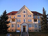
Manor of the manor
Former Wurgwitz town hall

Niederhermsdorfer Hof

Second school building in Wurgwitz

Alfred-Damm-Heim

_-_geo.hlipp.de_-_9934.jpg)
.JPG)


The State Office for the Preservation of Monuments in Saxony has placed 20 buildings under monument protection in the Wurgwitzer area. They can be seen in the list of cultural monuments in Wurgwitz . Most important in terms of local history are the manor Wurgwitz and the former town hall of the community as well as the Alfred-Damm-Heim as the cultural center of the place. In addition, three old school buildings in Wurgwitz and Niederhermsdorf are listed. As agricultural center can be found in Wurgwitz often three and Vierseithof with in the framework construction built residential houses stables and barns. Some of these rural houses are also on the list of cultural monuments.
The manor includes some outbuildings, some with half-timbering, and the former manor house, often referred to simply as "the villa". It was built in the neo-renaissance style and has a small tower. It is gradually being renovated for residential use. The surrounding garden is bordered by a quarry stone wall facing the “Am Weinberg” street. A little to the west of the manor house is a barn, which will be the home of the “Wurgwitzer Scheune eV” association in the future and which will be used for events.
The Wurgwitzer Town Hall was after the establishment of meeting of the 1925-1974 Wurgwitzer council. A branch of the Sparkasse was also housed in the building for many years. After 1974 it was no longer in use by the administration of the city of Freital. At the turn of the millennium, the old town hall was completely renovated and has been primarily a residential building since then. A doctor's practice is located on the ground floor. The tower and the reliefs attached to the gable and entrance are characteristic of the Wurgwitz townscape. At that time, the town hall was one of the first new buildings on Pesterwitzer Strasse; it is mainly surrounded by smaller residential buildings and the two former Wurgwitzer school buildings. The Alfred-Damm-Heim is on the left side of the street in the direction of Niederhermsdorf . The simple building was built in 1930 between the sports field, which was laid out in 1926, and the street. Since then, it has been the location for events of a cultural and sporting nature, and until 1982 it also served as a school sports classroom. Fundamental repairs and expansion took place between 2009 and 2011.
The last Niederhermsdorf school building, the " old school " on Unterstraße, housed local students for over a hundred years. Built in 1853 as the community's second school building, it was later given the tower with a clock through a private donation. After the unification of Wurgwitz and Niederhermsdorf, the students shared it with the " New School " in Wurgwitz. From 1982 there were lessons for children from both places in the prefabricated school building type Dresden Atrium on the street “Zur Quäne”. The old school is now privately owned by a carpentry company and has been partially renovated. The Wurgwitz students were previously housed in the New School. The community had it built in 1908 with a tower, clock, three classrooms and apartments for the headmaster and caretaker. On the portal there is the engraved writing “We learn for life”. The long vacant building was converted into a residential building in 2010. When it was built, the New School replaced the first Wurgwitz school building across the street, which was built in 1873 and is also a listed building.
The Niederhermsdorfer Hof , a four-sided farm on Oberhermsdorfer Straße built in the 18th century, is characteristic of the old town center of Niederhermsdorf . The Berger family runs a restaurant with a guesthouse and bowling alley there. Opposite was the former inn Niederhermsdorf from the 19th century until 2008 . Most recently it was the location of a consumer and residential building. Both buildings together with the surrounding residential development formed a closed core of the village. After the demolition, the Oberstraße was widened and led over the old inn property. The Gasthof Kohlsdorf on the corner of Pesterwitzer and Pennricher Strasse was an inn well known far beyond the village . The building complex with dining room, large dance hall and apartments was in this use until 1958 and was converted for residential purposes in 2017/18. Coming from Pesterwitz, it forms the distinctive entrance to Wurgwitz and Kohlsdorf.
The victims of the First World War formed the starting point for two memorials in Wurgwitz and Niederhermsdorf. Club members built a small park at the Wurgwitzer sports field and placed a memorial stone in honor of their fallen comrades. At the end of the National Socialists' efforts, another, larger war memorial was built on the Wiederitz in 1934. After the Second World War, it was rededicated as a memorial to the victims of war and tyranny and renovated in 2008.
Sports and events
The sports club "SG Wurgwitz" with the departments soccer , volleyball , table tennis , gymnastics , skiing and recreational sports uses a soccer field with large and small artificial turf fields and a beach volleyball court at the Alfred-Damm-Heim as well as the sports hall of the elementary school. In the Alfred-Damm-Heim, in addition to sports activities in the kindergarten, units from other SG Wurgwitz club sections take place.
Wurgwitz is considered a carnival stronghold in the region. Every year during the carnival season, events take place under the motto “Wurgwitz helau with jokes and noise!” In the Alfred-Damm-Heim and on the festival grounds at the sports field. This is also where the Wurgwitzer village festival, which is celebrated every year in June or July, has its point of view. A Christmas market is held in the “Wurgwitzer Scheune” at Christmas. The organizers of the events are the Carnival Association and the Wurgwitz Heimatverein as well as the Wurgwitzer Scheune eV
The Kultur- und Sportbund Wurgwitz, to which SG Wurgwitz as well as the Heimat- und Karnevalsverein belong, acts as the umbrella organization of the Wurgwitzer associations. In 2007, the Culture and Sports Association had around 370 members.
Economy and Infrastructure
traffic

In road traffic, Wurgwitz is mainly accessed via the "Kesselsdorfer Straße". It has the rank of a state road and connects the place to the northwest with Kesselsdorf and the federal highway 173 and the federal highway 17 . In the south-east it forms the connection to the Freital district of Zauckerode and further to the city center of Freitals. At the point where the Oberhermsdorfer Bach flows into the Wiederitz, the Kesselsdorfer Straße crosses the east-west axis from Oberhermsdorf to Pesterwitz. It connects the old town centers of Wurgwitz and Niederhermsdorf and, as a district road, is the responsibility of the district. The Wurgwitz road network comprises a total of 26 routes.
The main traffic arteries of the place are driven by the city and regional buses of the regional traffic Saxon Switzerland-Eastern Ore Mountains. Two Freital city bus lines and one regional transport line serve six stops in the local area.
The nearest train station from Wurgwitz is the Freital-Potschappel train station with a connection to the Dresden S-Bahn and the regional train via Chemnitz to Zwickau. Since the closure of the narrow-gauge railway to Nossen in 1972 , Wurgwitz no longer has its own connection to the rail network. A predominantly asphalted cycle path runs along the former narrow-gauge railway line, which leads from Potschappel and the local cycle path along the Wiederitz to Kesselsdorf, where it connects to the cycle and hiking paths around Wilsdruff. These connections are also often created on the former small railway lines of the Wilsdruffer network .
Resident Business and Tourism
After the end of the coal mining industry, there were hardly any larger businesses left in Wurgwitz. The place is still characterized by agriculture and craftsmanship. Today there is a building material and a timber trade, a recycling center operated by the Jakob Becker company and, since 2007, a quarry belonging to Eiffage Infra-Ost (formerly Faber ) on the northern Wurgwitz corridors. The Bombastus-Werke , based in Zauckerode, owns fields with a total area of over 40 hectares in Wurgwitz, on which they grow sage for the production of tea, medicines and homeopathics . Historically, Wurgwitz was the location of a gemstone cutting shop , which is still remembered today by the name of the bus stop in front of the former company premises. The gemstone grinding shop was founded in 1956 by Heinz Steiniger and had up to 60 employees (1969). Before the fall of the Wall, the plant operated as the Wurgwitz division of the VEB Edelschmiede Zwickau. After Steiniger's death in 1991, the company was dissolved in 1998.
Wurgwitz tourism is characterized by several small pensions and restaurants, including the “Niederhermsdorfer Hof” as a somewhat larger inn and the “Brasserie Ehrlich” in Wurgwitz. A three-star hotel on Pesterwitzer Strasse built in the 1990s was converted into a nursing home after bankruptcy.
education

The Wurgwitz primary school "Am Albertschacht" has received several awards, including the eTwinning quality seal from the European Commission. In the 2013/2014 school year, a total of 154 pupils studied in primary school in two classes per level. Ten full-time teachers are hired. The middle school that was located in the same building was closed in 2007 due to insufficient student numbers. Since then, the Wurgwitz high school students have been attending the Gotthold-Ephraim-Lessing High School in Potschappel or the Wilsdruff High School. The Weißeritz grammar school in Freital-Deuben is the closest grammar school to Wurgwitz. The vocational school center for technology and economics " Otto Lilienthal " is located in the Burgk district of Freital . The Technical University of Dresden with the Tharandt Forest Academy and the HTW Dresden are the closest colleges and universities.
Personalities
- Achim Schmidtchen (1928–1997), actor; born in Wurgwitz
- Walter Daehn (1929–2021), mayor of Wurgwitz and later Freitals
- Gerda Lepke (* 1939), painter and graphic artist; lives in Wurgwitz
literature
- Peter Kretzschmar: Wurgwitz 1206–2006: History and stories . Ed .: Kultur- und Sportbund Wurgwitz. Wurgwitz 2006.
- Lars-Arne Dannenberg , Vincenz Kaiser: Wilsdruff in the High Middle Ages. Considerations for the settlement of the Wilsdruffer Land and the development of the city with special consideration of the Jakobikirche . tape 80 , 2009, ISBN 978-3-87707-769-6 .
- Siegfried Huth, Roland Hanusch: Memories. Freital in the photo between 1950 and 1980 . Ed .: Wolfgang Burkhardt. Freital 2006.
- Heimatverein Wurgwitz: Wurgwitz 2011 - cultural monuments . Ed .: Heimatverein Wurgwitz. Wurgwitz 2010.
- Between Tharandter Wald, Freital and the Lockwitztal (= values of our homeland . Volume 21). 1st edition. Akademie Verlag, Berlin 1973.
Web links
Individual evidence
- ↑ a b Update of the Integrated Urban Development Concept (INSEK). (PDF; 120 MB) Urban development Freital 2030plus. Stadtverwaltung Freital, STEG Stadtentwicklung GmbH, January 2020, p. 92 , accessed on July 13, 2020 .
- ↑ Bulsitz (Bultzsch, Poltz) in historical digital gazetteer of Saxony .
- ^ Viticulture in Saxony. In: weingut-pesterwitz.de. Gut Pesterwitz, accessed June 8, 2014 .
- ↑ Kretzschmar 2006, p. 5 ff.
- ^ Wurgwitz with Niederhermsdorf and Kohlsdorf. In: freital.de. City administration Freital, accessed on July 23, 2018 .
- ↑ a b c d story. In: wurgwitz.de. Kultur- und Sportbund Freital-Wurgwitz, accessed on June 8, 2014 .
- ↑ a b c Wurgwitz in the Digital Historical Directory of Saxony .
- ↑ Kretzschmar 2006, p. 15.
- ^ Sächsisches Landesamt für Umwelt und Geologie / Sächsisches Oberbergamt (Hrsg.): The Döhlener basin near Dresden. Geology and mining . Freiberg 2006, ISBN 3-9811421-0-1 , p. 186 .
- ↑ Friedrich August Leßke: Contributions to the history and description of the Plauen reason, volume 1. Kommissions-Verlag Reuter, Dresden and Leipzig 1892, p. 258. ( digitized version )
- ↑ Kretzschmar 2006, p. 53.
- ↑ Kretzschmar 2006, p. 56.
- ↑ Kretzschmar 2006, p. 57.
- ↑ history. In: holzhandel-hahn.de. Holzhandel Hahn, accessed on June 8, 2014 .
- ↑ Kretzschmar 2006, p. 59.
- ^ Michael Rademacher: German administrative history from the unification of the empire in 1871 to the reunification in 1990. City and district of Dresden. (Online material for the dissertation, Osnabrück 2006).
- ↑ Kretzschmar 2006, p. 19.
- ↑ a b c d e f Heimatverein Wurgwitz (ed.): Wurgwitz 2011 - Kulturdenkmale . Wurgwitz 2010.
- ↑ Kretzschmar 2006, p. 19 f.
- ↑ Kretzschmar 2006, p. 87.
- ↑ a b Profile Sports Community Wurgwitz . In: Saxon newspaper . May 13, 2004.
- ↑ Around Freital (II). ( PDF ; 38 KB) In: freital.de. City administration Freital, accessed on July 23, 2017 .
- ↑ Kretzschmar 2006, p. 91.
- ↑ Kretzschmar 2006, p. 22 f.
- ↑ Kretzschmar 2006, p. 25.
- ↑ Thomas Morgenroth: Freital's former mayor Walter Daehn is dead . In: Saxon newspaper . February 9, 2021 ( saechsische.de [accessed February 10, 2021]).
- ↑ Kretzschmar 2006, p. 40 f.
- ↑ Kretzschmar 2006, p. 91.
- ↑ Kretzschmar 2006, p. 93.
- ↑ Kretzschmar 2006, p. 97 ff.
- ↑ Kretzschmar 2006, p. 25.
- ↑ Municipal council election 1994. Eligible voters, voters, ballot papers, distribution of votes and seats in the election on June 12, 1994 in the municipality of Freital, city; Weißeritzkreis. In: statistik.sachsen.de. State Statistical Office of Saxony , accessed on October 14, 2014 .
- ↑ Kretzschmar 2006, p. 25.
- ↑ Great artificial turf instead of a sanding disc . In: Saxon newspaper . November 25, 2004.
- ↑ Wurgwitz celebrated its 800 years. In: wurgwitz.de. Kultur- und Sportbund Freital-Wurgwitz, accessed on June 8, 2014 .
- ↑ 10666 - Wurgwitz manor. In: archiv.sachsen.de. Main State Archive Dresden , archived from the original on July 14, 2014 ; Retrieved June 8, 2014 .
- ↑ Kretzschmar 2006, p. 16.
- ↑ Federal Statistical Office (ed.): Municipalities 1994 and their changes since 01.01.1948 in the new federal states . Metzler-Poeschel, Stuttgart 1995, ISBN 3-8246-0321-7 , pp. 269 .
- ↑ Main statutes of the large district town of Freital. ( PDF ; 22 KB) In: freital.de. Stadtverwaltung Freital, January 1, 2013, p. 9 , accessed on July 23, 2018 .
- ^ Local councils . In: freital.de. City administration Freital, accessed on July 23, 2018 .
- ^ Eligible voters, voters, ballot papers, distribution of votes and seats in the election on June 12, 1994 in the village of Wurgwitz; Freital community, city; Weißeritzkreis. In: statistik.sachsen.de. State Statistical Office of Saxony, accessed on September 3, 2015 .
- ↑ Local council election 1999, municipality Freital, city, locality Wurgwitz, final result. In: statistik.sachsen.de. State Statistical Office of Saxony, accessed on September 3, 2015 .
- ↑ Eligible voters, voters, ballot papers, distribution of votes and seats in the election on June 13, 2004 in the village of Wurgwitz; Freital community, city; Weißeritzkreis. In: statistik.sachsen.de. State Statistical Office of Saxony, accessed on September 3, 2015 .
- ↑ Eligible voters, voters, ballot papers, distribution of votes and seats in the election on June 7, 2009 in the village of Wurgwitz; district town of Freital; District of Saxon Switzerland-Eastern Ore Mountains. In: statistik.sachsen.de. State Statistical Office of Saxony, accessed on September 3, 2015 .
- ↑ Eligible voters, voters, ballot papers, distribution of votes and seats in the election on May 25, 2014 in the village of Wurgwitz; district town of Freital; District of Saxon Switzerland-Eastern Ore Mountains. In: statistik.sachsen.de. State Statistical Office of Saxony, accessed on September 3, 2015 .
- ↑ Local council election 2019 - distribution of seats in the village of Wurgwitz - preliminary results. In: wahlen.sachsen.de. State Statistical Office of Saxony, accessed on June 17, 2019 .
- ↑ Stadtverwaltung Freital (ed.): Monuments in Freital - workshop report 3 of a municipal working group against forgetting . Freital 2013, p. 86-89 .
- ^ A b Matthias Weigel: Sports facility construction burdens club coffers . In: Saxon newspaper . June 29, 2010.
- ↑ "The New" Wurgwitz Barn. In: wurgwitzerscheune.de. Wurgwitzer Scheune eV, accessed on October 7, 2014 .
- ↑ Kretzschmar 2006, p. 64.
- ↑ Kretzschmar 2006, p. 67.
- ↑ Wurgwitzer School becomes a residential building . In: Saxon newspaper . June 12, 2009.
- ↑ Kretzschmar 2006, p. 65.
- ↑ Kretzschmar 2006, p. 50.
- ↑ Niederhermsdorfer Hof - guesthouse, restaurant, bowling alley in Freital. In: niederhermsdorfer-hof.de. Retrieved October 7, 2014 .
- ↑ Kretzschmar 2006, p. 51.
- ↑ News . In: Saxon newspaper . January 24, 2011.
- ^ SG Wurgwitz. In: wurgwitz.de. Kultur- und Sportbund Freital-Wurgwitz, accessed on June 8, 2014 .
- ↑ With joke and noise - Wurgwitz Helau! In: karnevalsclubwurgwitz.de. Wurgwitz Carnival Club, accessed on June 8, 2014 .
- ↑ Culture and Sports Association Freital-Wurgwitz . In: Saxon newspaper . July 25, 2007.
- ↑ Freital city traffic. In: rvd.de. Regionalverkehr Dresden , accessed on October 7, 2014 .
- ↑ Cycling in and around Dresden: Edgar-Rudolph-Radweg. In: dresden-lexikon.de. Retrieved October 7, 2014 .
- ↑ Wurgwitz quarry. In: faber-rohstoff.de. FARBO - FABER raw materials, archived from the original on December 27, 2013 ; Retrieved May 20, 2013 .
- ↑ Training documents for the socialist vocational training “precious metal skilled workers”. In: museum-digital.de. Bitterfeld District Museum , accessed on June 8, 2014 .
- ↑ Kretzschmar 2006, p. 104 f.
- ↑ Achievements. In: gs-wurgwitz.de.vu. Primary school "Am Albertschacht" Freital-Wurgwitz, accessed on June 20, 2014 .
- ↑ School portrait. In: Saxon school database. Saxon State Ministry for Culture , accessed on June 20, 2014 .
Birkigt | Burgk | Deuben | Döhlen | Hainsberg | Kleinnaundorf | Ugly | Pesterwitz | Potschappel | Saalhausen | Schweinsdorf | Somsdorf | Whitish | Wurgwitz | Zauckerode
Birkigt | Coßmannsdorf | Deuben | Döhlen | Großburgk | Hainsberg | Kleinburgk | Kleinnaundorf | Kohlsdorf | Ugly | Niederhermsdorf | Niederpesterwitz | Oberpesterwitz | Potschappel | Saalhausen | Schweinsdorf | Somsdorf | Under white | Whitish | Wurgwitz | Zauckerode | Zschiedge