Parazinho: Difference between revisions
Content deleted Content added
m r2.7.3) (Robot: Adding zh:Parazinho |
No edit summary |
||
| (11 intermediate revisions by 10 users not shown) | |||
| Line 6: | Line 6: | ||
|native_name = <!-- for cities whose native name is not in English --> |
|native_name = <!-- for cities whose native name is not in English --> |
||
|nickname = |
|nickname = |
||
|settlement_type =Municipality |
|settlement_type =Municipality |
||
|motto = |
|motto = |
||
<!-- images and maps -----------> |
<!-- images and maps -----------> |
||
|image_skyline = |
|image_skyline = Parazinho - State of Rio Grande do Norte, Brazil - panoramio.jpg |
||
|imagesize = |
|imagesize = 350px |
||
|image_caption = |
|image_caption = Parazinho and its beach and the surrounding mountains |
||
|image_flag = |
|image_flag = Bandeira de Parazinho (RN).png |
||
|flag_size = |
|flag_size = |
||
|image_seal = |
|image_seal = Brasão de Parazinho (RN).png |
||
|seal_size = |
|seal_size = |
||
|image_map = |
|image_map = RioGrandedoNorte Municip Parazinho.svg |
||
|mapsize = |
|mapsize = 350px |
||
|map_caption = |
|map_caption = Location of Parazinho |
||
|pushpin_map = |
|pushpin_map = |
||
|pushpin_label_position =bottom |
|pushpin_label_position =bottom |
||
| Line 46: | Line 46: | ||
|area_land_km2 = <!--See table @ Template:Infobox Settlement for details on automatic unit conversion--> |
|area_land_km2 = <!--See table @ Template:Infobox Settlement for details on automatic unit conversion--> |
||
<!-- Population -----------------------> |
<!-- Population -----------------------> |
||
|population_as_of = |
|population_as_of = 2020 <ref>[https://cidades.ibge.gov.br/brasil/rn/parazinho/panorama IBGE 2020]</ref> |
||
|population_footnotes = |
|population_footnotes = |
||
|population_note = |
|population_note = |
||
|population_total = |
|population_total = 5,272 |
||
|population_density_km2 = |
|population_density_km2 = |
||
<!-- General information ---------------> |
<!-- General information ---------------> |
||
|timezone = |
|timezone = [[Time in Brazil|BRT]] |
||
|utc_offset = |
|utc_offset = −3 |
||
|timezone_DST = |
|timezone_DST = |
||
|utc_offset_DST = |
|utc_offset_DST = |
||
|coordinates = |
|||
|latd=|latm= |lats= |latNS=N |
|||
|longd=|longm=|longs=|longEW=E |
|||
|elevation_footnotes = <!--for references: use <ref> tags--> |
|elevation_footnotes = <!--for references: use <ref> tags--> |
||
|elevation_m = |
|elevation_m = |
||
| Line 70: | Line 69: | ||
|footnotes = |
|footnotes = |
||
}} |
}} |
||
'''Parazinho''' is a |
'''Parazinho''' is a [[Municipalities of Brazil|municipality]] in the [[states of Brazil|state]] of [[Rio Grande do Norte]] in the [[Northeast Region, Brazil|Northeast region]] of [[Brazil]].<ref name="IBGE_DTB_2008">{{cite web |url=https://geoftp.ibge.gov.br/organizacao_do_territorio/estrutura_territorial/divisao_territorial/2008/dtb_2008.zip |title=Divisão Territorial do Brasil |date=July 1, 2008 |publisher=Divisão Territorial do Brasil e Limites Territoriais, Instituto Brasileiro de Geografia e Estatística (IBGE) |accessdate=December 17, 2009|language=Portuguese}}</ref><ref name="IBGE_Pop_2009">{{cite web | url = http://www.ibge.gov.br/home/estatistica/populacao/estimativa2009/POP2009_DOU.pdf | title = Estimativas da população para 1º de julho de 2009| publisher = Estimativas de População, Instituto Brasileiro de Geografia e Estatística (IBGE) | date = August 14, 2009 | accessdate=December 17, 2009 | format = [[PDF]]|language=Portuguese }}</ref><ref name="PNUD_IDH_2000">{{cite web |url=http://www.pnud.org.br/atlas/ranking/IDH-M%2091%2000%20Ranking%20decrescente%20(pelos%20dados%20de%202000).htm |title=Ranking decrescente do IDH-M dos municípios do Brasil |date=2000 |publisher=Atlas do Desenvolvimento Humano, Programa das Nações Unidas para o Desenvolvimento (PNUD) |accessdate=December 17, 2009 |language=Portuguese |archive-url=https://web.archive.org/web/20091003103229/http://www.pnud.org.br/atlas/ranking/IDH-M%2091%2000%20Ranking%20decrescente%20%28pelos%20dados%20de%202000%29.htm |archive-date=October 3, 2009 |url-status=dead }}</ref><ref name="IBGE_PIB_2005">{{cite web |url=http://www.ibge.gov.br/home/estatistica/economia/pibmunicipios/2005/tab01.pdf |title=Produto Interno Bruto dos Municípios 2002-2005 |date=December 19, 2007 |publisher=Instituto Brasileiro de Geografia e Estatística (IBGE) |accessdate=December 17, 2009|language=Portuguese}}</ref> |
||
Its seal has a ground of a countryside with a tree, on top is a blue star, surrounding are two different type of palm trees founded in the area, on the bottom is the municipality name in a green ribbon with yellow letters. Its flag colors are green, white and blue with the seal in the middle. |
|||
==See also== |
==See also== |
||
| Line 77: | Line 78: | ||
==References== |
==References== |
||
{{reflist}} |
{{reflist}} |
||
| ⚫ | |||
{{coord|5.22278|S|35.8378|W|source:kolossus-ptwiki|display=title}} |
{{coord|5.22278|S|35.8378|W|source:kolossus-ptwiki|display=title}} |
||
[[Category: |
[[Category:Municipalities in Rio Grande do Norte]] |
||
| ⚫ | |||
[[es:Parazinho]] |
|||
[[eo:Parazinho]] |
|||
[[bpy:পারাজিনহো]] |
|||
[[it:Parazinho]] |
|||
[[kk:Паразинью]] |
|||
[[mg:Parazinho]] |
|||
[[nl:Parazinho]] |
|||
[[no:Parazinho]] |
|||
[[pt:Parazinho]] |
|||
[[ro:Parazinho]] |
|||
[[ru:Паразинью]] |
|||
[[vi:Parazinho]] |
|||
[[vo:Parazinho]] |
|||
[[war:Parazinho]] |
|||
[[zh:Parazinho]] |
|||
Latest revision as of 13:57, 23 August 2022
Parazinho | |
|---|---|
Municipality | |
 Parazinho and its beach and the surrounding mountains | |
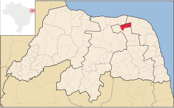
 Location of Parazinho | |
| Country | |
| Region | Nordeste |
| State | Rio Grande do Norte |
| Mesoregion | Agreste Potiguar |
| Population (2020 [1]) | |
| • Total | 5,272 |
| Time zone | UTC−3 (BRT) |
Parazinho is a municipality in the state of Rio Grande do Norte in the Northeast region of Brazil.[2][3][4][5]
Its seal has a ground of a countryside with a tree, on top is a blue star, surrounding are two different type of palm trees founded in the area, on the bottom is the municipality name in a green ribbon with yellow letters. Its flag colors are green, white and blue with the seal in the middle.
See also[edit]
References[edit]
- ^ IBGE 2020
- ^ "Divisão Territorial do Brasil" (in Portuguese). Divisão Territorial do Brasil e Limites Territoriais, Instituto Brasileiro de Geografia e Estatística (IBGE). July 1, 2008. Retrieved December 17, 2009.
- ^ "Estimativas da população para 1º de julho de 2009" (PDF) (in Portuguese). Estimativas de População, Instituto Brasileiro de Geografia e Estatística (IBGE). August 14, 2009. Retrieved December 17, 2009.
- ^ "Ranking decrescente do IDH-M dos municípios do Brasil" (in Portuguese). Atlas do Desenvolvimento Humano, Programa das Nações Unidas para o Desenvolvimento (PNUD). 2000. Archived from the original on October 3, 2009. Retrieved December 17, 2009.
- ^ "Produto Interno Bruto dos Municípios 2002-2005" (PDF) (in Portuguese). Instituto Brasileiro de Geografia e Estatística (IBGE). December 19, 2007. Retrieved December 17, 2009.


