
Rio Grande do Norte
| Estado do Rio Grande do Norte Rio Grande do Norte |
|||
|---|---|---|---|
|
|||
| Coordinates | 5 ° 44 ′ S , 36 ° 33 ′ W | ||

|
|||
| Symbols | |||
|
|||
| founding | 1889 (state) | ||
| Basic data | |||
| Country | Brazil | ||
| State | Rio Grande do Norte | ||
| Capital | natal | ||
| ISO 3166-2 | BR-RN | ||
| Região intermediária | 3 | ||
| Região imediata | 11 | ||
| Mesoregion | 4 (until 2017) | ||
| Microregion | 19 (until 2017) | ||
| surface | 52,811.1 km² | ||
| Residents | 3,168,027 (2010) | ||
| density | 60 Ew. / km² | ||
| estimate | 3,506,853 Ew. (last: July 1, 2019) |
||
| Time zone | UTC −3 | ||
| Website | www.rn.gov.br (Brazilian Portuguese) | ||
| politics | |||
| Governor | Fátima Bezerra (2019-2022) | ||
| Political party | (PT) | ||
| economy | |||
| GDP | 36,103 thousand R $ (BRL) 11,287 R $ (BRL) per capita (2011) |
||
| HDI | 0.684 (2010) | ||


Rio Grande do Norte [ xiu ˈgɾɐ̃dʲi du ˈnɔxtʲi ] (literally: " great river of the north "; officially Portuguese Estado do Rio Grande do Norte ) is the north-easternmost state of Brazil and also the north-easternmost corner of South America . The capital is Natal .
Rio Grande do Norte is dominated by the coastline, it is famous for its beaches and sand dunes. The state has 410 km of sandy beaches, with lagoons and coconut trees. The most famous beaches are Praia de Cajueiro , Genipabu (north of Natal ) with up to 50 m high sand dunes. Baía Formosa is a beach in the south of the state. It has offshore reefs and is popular with surfers. Sagi Beach is further south.
The inhabitants call themselves Potiguar after an Indian tribe from the area.
geography
Rio Grande do Norte borders the Brazilian states of Ceará and Paraíba and the Atlantic Ocean . According to the 2010 census, Rio Grande do Norte had 3,168,027 inhabitants and an area of 52,811 km². The population density is thus 60 inhabitants per km². The Brazilian Statistics Institute (IBGE) estimated the population as of July 1, 2019 at 3,506,853 inhabitants, which results in an increased population density of 66.4 inhabitants per km². The Rocas Atoll in the Atlantic, 260 km northeast of Natal, also belongs to the state.
According to the Köppen and Geiger climate classification, the climate is tropical and semi-arid (Aw, BSh).
history
The Spaniard Alonso de Ojeda was probably the first European to see the region in 1499. European sailors landed for the first time in 1501 on the northeastern tip of South America, Cabo São Roque , 32 km north of today's Natal. It was a Portuguese expedition under Amerigo Vespucci that lasted from 1501 to 1502. The cape was named after Rochus de Montpellier , the day saint on the day of discovery (August 16).
In the decades that followed, there were no permanent European settlements in the region inhabited by the Potiguar tribe. 1534 were from Johann III. Established captains in the New World and given the captaincy of Rio Grande to João de Barros in 1535 , marking the beginning of the colonization of the area. After the colonial days of Brazil, the province of Rio Grande do Norte was established from the core area when the Empire of Brazil was founded in 1822 , and after the republic was founded in 1889, it was converted into the state of Rio Grande do Norte (Estado do Rio Grande do Norte).
politics
Following the elections in Brazil in 2018, the state governor has been Fátima Bezerra of the Workers' Party (PT) since January 1, 2019 , while Antenor Roberto Soares de Medeiros of the PCdoB is vice-governor . Parliament is the unicameral system of the legislative assembly of Rio Grande do Norte .
population
Around a third of the state's population lives in the Natal metropolitan area . Another population center is the city of Mossoró on the north coast. The rest of the state is sparsely populated.
Population development

Source:
Cities
The ten most populous cities in Rio Grande do Norte are according to the 2010 census by the IBGE with population estimates as of July 1, 2018:
![]() Map with all coordinates of the cities section : OSM
Map with all coordinates of the cities section : OSM
| local community | Population census 2010 |
2018 estimate |
|
|---|---|---|---|
| 1 |
natal |
803.739 | 877.640 |
| 2 |
Mossoró |
241,645 | 294.076 |
| 3 |
Parnamirim |
202.456 | 255.793 |
| 4th |
São Gonçalo do Amarante |
87,668 | 101.102 |
| 5 |
Macaíba |
69,467 | 79,743 |
| 6th |
Ceará-Mirim |
68.141 | 73,099 |
| 7th |
Caicó |
62,709 | 67,554 |
| 8th |
Açu (Assu) |
53,227 | 57,644 |
| 9 |
Currais Novos |
42,652 | 44,664 |
| 10 |
Sao José de Mipibu |
39,776 | 43,640 |
Picture gallery
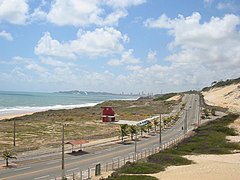
Natal Beach
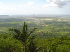
Sertão in the interior of Rio Grande do Norte

Traditional house in the Sertão


literature
- Sérgio Luiz Bezerra Trindade: História do Rio Grande do Norte. Editora do IFRN, Natal 2010, ISBN 978-85-89571-77-7 (PDF; 18.7 MB).
Web links
- Rio Grande do Norte government website (Brazilian Portuguese)
- Assembleia Legislativa do Estado do Rio Grande do Norte , Legislative Assembly website (Brazilian Portuguese)
Individual evidence
- ↑ a b c Instituto Brasileiro de Geografia e Estatística (IBGE): Estados @ Rio Grande do Norte: Panorama. Retrieved September 5, 2019 (Brazilian Portuguese).
- ↑ Fatima Bezerra 13 (Governadora). In: todapolitica.com. Eleições 2018, accessed September 5, 2019 (Brazilian Portuguese).
- ↑ SIDRA database of the IBGE
- ↑ IBGE : Cidades @ Rio Grande do Norte . Retrieved July 11, 2019 (Brazilian Portuguese, English, Spanish).
Acre | Alagoas | Amapá | Amazon | Bahia | Ceará | ( Distrito Federal do Brasil ) | Espírito Santo | Goiás | Maranhão | Mato Grosso | Mato Grosso do Sul | Minas Gerais | Pará | Paraíba | Paraná | Pernambuco | Piauí | Rio de Janeiro | Rio Grande do Norte | Rio Grande do Sul | Rondônia | Roraima | Santa Catarina | São Paulo | Sergipe | Tocantins