
Mato Grosso
| Mato Grosso | |||
|---|---|---|---|
  |
|||
| Symbols | |||
|
|||
| Basic data | |||
| Country | Brazil | ||
| Capital | Cuiabá | ||
| surface | 903,366.2 km² | ||
| Residents | 3,484,466 (estimate as of July 1, 2019) | ||
| density | 3.9 inhabitants per km² | ||
| ISO 3166-2 | BR-MT | ||
| politics | |||
| governor | Mauro Mendes ( DEM ) | ||
| economy | |||
| GDP | 101,235 million R $ 31,397 R $ per capita (2014) |
||


Coordinates: 13 ° S , 56 ° W

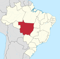
Mato Grosso , officially Portuguese Estado de Mato Grosso , is a federal state in the interior of Brazil . He belongs to the Região Centro-Oeste . Its capital is Cuiabá .
geography
Mato Grosso has a national border with Bolivia in the southwest . It also borders (starting clockwise from the west) with the Brazilian states of Rondônia , Amazonas , Pará , Tocantins , Goiás and Mato Grosso do Sul .
The capital is Cuiabá with an estimated population of 612,547 as of July 1, 2019. Other smaller towns in Mato Grosso are u. a. Várzea Grande, Rondonópolis, Cáceres and Sinop.
Mato Grosso has an area of around 903,207 km² (2018) only on July 1, 2019, an estimated 3.48 million inhabitants. The state is therefore one of the most sparsely populated regions in Brazil with a population density of only 3.5 people per square kilometer (2013).
The highest point in the state is the Serra Manto Cristo at 1,118 m. The most important rivers are Paraguai, Juruena, Teles Pires, Xingu, Araguaia, Piqueri, Cuiabá, São Lourenço das Mortes. In the southwest of Mato Grosso is the Pantanal wetland .
Cities
The largest cities with their estimated population as of July 1, 2019 are:
- Cuiabá - 612,547
- Várzea Grande - 284,971
- Rondonópolis - 232,491
- Sinop - 142,996
- Tangara da Serra - 103,750
- Cáceres - 94,376
- Sorriso - 90,313
- Primavera do Leste - 62.019
- Barra do Garças - 61.012
- Alta Floresta - 51,782
- Pontes e Lacerda - 45,436
- Juína - 40,997
- Guaranta do Norte - 35,816
- Juara - 34,974
- Barra do Bugres - 34,966
- Poconé - 32,843
Mato Grosso is administratively divided into 9 regions with 140 municipalities ( municípios ). It is inhabited u. a. by the Rio Pardo Indians .
History and culture
The southern part was separated from the territory of the federal state on January 1, 1979 and has since formed Mato Grosso do Sul .
politics
Mauro Mendes of the Democratas (DEM), who replaced his predecessor Pedro Taques , has been the governor since January 1, 2019 . In Brazil's 2018 gubernatorial elections , he received 840,094, or 58.69% of the valid votes. His lieutenant governor was Otaviano Pivetta des Partido Democrático Trabalhista (PDT)
The legislative power lies with the legislative assembly of Mato Grosso of 25 elected members.
economy
In 2004, agriculture had the largest share in economic output with 40.8%, followed by the service sector with 40.2%. The industrial sector contributed 19%. In 2012, Mato Grosso exported goods worth around US $ 16 billion, primarily soybeans (40.6%) and soybean meal (16.4%), as well as grain (17.7%) and cotton.
Web links
- - Governo do Estado Mato Grosso (Brazilian Portuguese)
Individual evidence
- ↑ a b Mato Grosso - Panorama. In: cidades.ibge.gov.br. IBGE , accessed September 3, 2019 (Brazilian Portuguese).
- ↑ Mauro Mendes (DEM) toma posse como governador de MT nesta terça-feira (1º). In: globo.com. G1, accessed September 3, 2019 (Brazilian Portuguese).
- ↑ IBGE: Notícias: Contas Regionais 2014: cinco estados responderam por quase dois terços do PIB do país. Retrieved March 7, 2017 (Portuguese).
- ↑ Cuiabá - Panorama. In: cidades.ibge.gov.br. IBGE , accessed September 3, 2019 (Brazilian Portuguese).
- ↑ Mauro Mendes 25 (DEM) Governador - Mato Grosso - Eleições 2018. In: com.br. Gazeta do Povo, November 13, 2018, accessed May 28, 2020 (Brazilian Portuguese).
- ↑ Exports of Mato Grosso (2012) ( Memento of the original from April 2, 2015 in the Internet Archive ) Info: The archive link was inserted automatically and has not yet been checked. Please check the original and archive link according to the instructions and then remove this notice. on DataViva, accessed March 3, 2015
Acre | Alagoas | Amapá | Amazon | Bahia | Ceará | ( Distrito Federal do Brasil ) | Espírito Santo | Goiás | Maranhão | Mato Grosso | Mato Grosso do Sul | Minas Gerais | Pará | Paraíba | Paraná | Pernambuco | Piauí | Rio de Janeiro | Rio Grande do Norte | Rio Grande do Sul | Rondônia | Roraima | Santa Catarina | São Paulo | Sergipe | Tocantins