
Administrative division of Brazil
The Federal Republic of Brazil is divided into 26 states and one federal district ( Distrito Federal do Brasil ). Below the states, the next highest independent administrative level is the municipalities . The federal district consists of a single municipality, the city of Brasília .
Federal units
| State | Capital | population 2017 |
Area in km² |
Communities | Abbreviation | region |
|---|---|---|---|---|---|---|
|
|
Porto Velho | 1,805,788 | 238,512.8 | 52 | BR-RO | north |
|
|
Rio Branco | 829.619 | 153,149.9 | 22nd | BR-AC | north |
|
|
Manaus | 4,063,614 | 1,577,820.2 | 62 | BR-AM | north |
|
|
Boa Vista | 522.636 | 225,116.2 | 15th | BR-RR | north |
|
|
Belém | 8,366,628 | 1,253,164.5 | 143 | BR-PA | north |
|
|
Macapá | 797.722 | 143,453.7 | 16 | BR-AP | north |
|
|
Palmas | 1,550,194 | 277,620.9 | 139 | BR-TO | north |
|
|
São Luís | 7,000,229 | 331,983.3 | 217 | BR-MA | Northeast |
|
|
Teresina | 3,219,257 | 252,378.6 | 224 | BR-PI | Northeast |
|
|
Fortaleza | 9,020,460 | 146,348.3 | 184 | BR-CE | Northeast |
|
|
natal | 3,507,003 | 53,806.8 | 167 | BR-RN | Northeast |
|
|
João Pessoa | 4,025,558 | 56,489.8 | 223 | BR-PB | Northeast |
|
|
Recife | 9,473,266 | 98,937.8 | 185 | BR-PE | Northeast |
|
|
Maceió | 3,375,823 | 27,767.7 | 102 | BR-AL | Northeast |
|
|
Aracaju | 2,288,116 | 22,050.3 | 75 | BR-SE | Northeast |
|
|
Salvador da Bahia | 15,344,447 | 567,295.5 | 417 | BR-BA | Northeast |
|
|
Belo Horizonte | 21,119,536 | 588,383.6 | 853 | BR-MG | southeast |
|
|
Vitória | 4,016,356 | 46,184.1 | 78 | BR-ES | southeast |
|
|
Rio de Janeiro | 16,718,956 | 43,909.7 | 92 | BR-RJ | southeast |
|
|
São Paulo | 45.094.866 | 248,808.8 | 645 | BR-SP | southeast |
|
|
Curitiba | 11,320,892 | 199,709.1 | 399 | BR-PR | south |
|
|
Florianópolis | 7.001.161 | 95,442.9 | 293 | BR-SC | south |
|
|
Porto Alegre | 11,322,895 | 281,370.0 | 496 | BR-RS | south |
|
|
Campo Grande | 2,713,147 | 358,158.7 | 78 | BR-MS | Midwest |
|
|
Cuiabá | 3,344,544 | 906,806.9 | 141 | BR-MT | Midwest |
|
|
Goiânia | 6,778,772 | 340,086.7 | 246 | BR-GO | Midwest |
|
|
Brasília | 3,039,444 | 5,789.2 | 1 | BR-DF | Midwest |
|
|
Brasília | 207.660.929 | 8,515,770 | 5,570 | BR |
Communities
The municipalities (in Portuguese Municípios ) take on the essential administrative tasks. There are a total of 5570 parishes (as of 2015) , which are usually headed by a prefect. There are no community-free areas . The state of Minas Gerais has the most parishes with 853.
The allocation as small , medium , large town etc. is based on the number of inhabitants according to the following table:
| Local name | meaning | Residents |
|---|---|---|
| Cidade pequena | Town | up to 100,000 |
| Cidade média-pequena | medium small town | > 50,000 to 100,000 |
| Cidade média | Mittelstadt | > 100,000 to 300,000 |
| Cidade média-grande | big middle town | > 300,000 to 500,000 |
| Metro (Cidade Maior) |
Big city, metropolis | > 500,000 |
Sub-prefectures
Particularly large cities, such as São Paulo and Rio de Janeiro , are divided into sub-prefectures ( Portuguese subprefeituras ). São Paulo has 32 sub-prefectures and Rio de Janeiro 8.
Administrative regions
Some major cities, such as B. Brasília and Rio de Janeiro , are divided into administrative regions ( Portuguese Regiões administrativas ). The 33 administrative regions of Rio de Janeiros represent sub-units of the sub-prefectures.
Historical development


_-_de_-_colored.svg)
Statistical breakdown
The areas formed for geostatistical reasons, the regions (including macroregions ), mesoregions and microregions do not belong to the administrative units . They are not local authorities .
Statistical regions
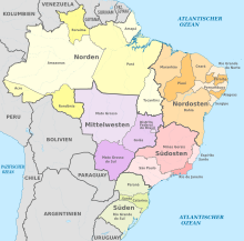
Today's five “regions” represent the largest statistical areas within Brazil.


North (Região Norte)

The Região Norte makes up 45.27% of the area of Brazil. At the same time, it is the region with the second lowest population, namely 15,864,454 in the 2010 census.
The west of the northern region is underdeveloped industrially and not very well developed. In return, it is home to the largest ecosystem on earth, the Amazon basin .
The North Region includes the states:
Northeast (Região Nordeste)

A good quarter of Brazilians, 53,081,950 inhabitants, live in the Nordeste region. The region is culturally very diverse. It is shaped by the Portuguese colonial rule, by the African culture of the former slaves and, last but not least, by Indian influences.
Midwest (Região Centro-Oeste)

With 14,058,094 inhabitants, the region with the poorest population owes its importance above all to its wealth of raw materials. Nevertheless, the Região Centro-Oeste is not particularly well developed. However, intensive efforts are being made to strengthen the region, including a. by moving the capital to Brasília.
Southeast (Região Sudeste)

The Região Sudeste is the second smallest region in Brazil. With over 80 million inhabitants, about 42% of Brazilians live in it, which is more than in any other South American country. With the metropolitan areas of São Paulo and Rio de Janeiro , this region is the country's economic engine.
South (Região Sul)

The Região Sul is the smallest region in Brazil. The climatic conditions correspond roughly to those of southern Europe. The region shows clear cultural influences from German and Italian immigrants, who preferred to settle in this area. About 85% of the 27,386,891 residents are white.
See also
Web links
- Brazilian communities on www.municipionline.com.br
swell
- ↑ Results of the census of August 1, 2010 (PDF; 74 kB) Instituto Brasileiro de Geografia e Estatística, accessed on September 22, 2013.
- ↑ Publication of the results of the census of August 1, 2010 (PDF; 55 kB) Instituto Brasileiro de Geografia e Estatística, accessed on September 22, 2013.
- ↑ ISO_3166-2: BR - codes for the 26 Brazilian states and the Federal District
Antigua and Barbuda | Argentina | Bahamas | Barbados | Belize | Bolivia | Brazil | Chile | Costa Rica | Dominica | Dominican Republic | Ecuador | El Salvador | Grenada | Guatemala | Guyana | Haiti | Honduras | Jamaica | Canada | Colombia | Cuba | Mexico | Nicaragua | Panama | Paraguay | Peru | St. Kitts and Nevis | St. Lucia | St. Vincent and the Grenadines | Suriname | Trinidad and Tobago | Uruguay | Venezuela | United States
Administrative division of the States of:
Africa |
Asia |
Australia and Oceania |
Europe |
North and South America