Macapá
| Macapá | ||
|---|---|---|
|
Coordinates: 0 ° 2 ′ S , 51 ° 3 ′ W Macapá on the map of Brazil
|
||
| Basic data | ||
| Country |
|
|
| State |
|
|
| City foundation | 1758 | |
| Residents | 397,913 (2010) | |
| City insignia | ||
| Detailed data | ||
| surface | 6502.105 | |
| Population density | 62 inhabitants / km 2 | |
| Post Code | 68900-000 | |
| prefix | (+55) 96 | |
| City Presidency |
City Prefect: Clécio Luis ( REDE ) (2017–2020) |
|
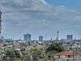
| View of the center of Macapá | ||
| Location of the municipality in the state of Amapá | ||
Macapá , officially Município de Macapá , is the capital of the Brazilian state of Amapá . It is located in the north of the country directly on the equator and the mouth of the Amazon , north of the island of Marajó . Macapá had 344,153 inhabitants (as of 2010, IBGE census ) on an area of around 6503 square kilometers (as of 2017). The population density is thus 62 inhabitants per square kilometer. The population was estimated by the IBGE on July 1, 2019 at 503,327 inhabitants, who are called Macapaenser. The city is the center of the Macapá metropolitan region .
history
In 1738 the fortification Fortaleza de São José de Macapá was built around which a settlement was formed. This was raised to the Vila de São José de Macapá on February 2, 1758 , which is considered the actual date of foundation. On September 6, 1856, the settlement received the status of a city under the name Cidade de Macapá and is now a Munizip .
Climate table
| Macapá | ||||||||||||||||||||||||||||||||||||||||||||||||
|---|---|---|---|---|---|---|---|---|---|---|---|---|---|---|---|---|---|---|---|---|---|---|---|---|---|---|---|---|---|---|---|---|---|---|---|---|---|---|---|---|---|---|---|---|---|---|---|---|
| Climate diagram | ||||||||||||||||||||||||||||||||||||||||||||||||
| ||||||||||||||||||||||||||||||||||||||||||||||||
|
Average monthly temperatures and rainfall for Macapá
Source: wetterkontor.de
|
|||||||||||||||||||||||||||||||||||||||||||||||||||||||||||||||||||||||||||||||||||||||||||||||||||||||||||||||||||||||||||||||||||||||||||||||||||||||||||||||||||||
Infrastructure
The Macapa Airport has a great importance for traffic. Macapá is not directly connected to the national highway network with other state capitals. The city is connected via the BR-156 and BR-210 .
Diocese of Macapá
Sports
The city is known for the local football stadium Estádio Milton Corrêa . This was laid out so that the equator should form the center line of the soccer field. It was completed in 1990. In fact, the equator runs through the south stand because of a measurement error; the playing field itself lies entirely in the northern hemisphere. The stadium is no longer in use.
Personalities
- Davi Alcolumbre (* 1977), politician
Web links
- City Prefecture website , Prefeitura Municipal Citizens' Portal (Brazilian Portuguese)
- City Council website , Câmara Municipal (Brazilian Portuguese)
Individual evidence
- ↑ a b IBGE : Macapá - Panorama. . Retrieved August 31, 2019 (Brazilian Portuguese).
- ↑ IBGE : Macapá - História. Retrieved January 26, 2019 (Brazilian Portuguese).


