Tartarugalzinho
| Município de Tartarugalzinho Tartarugalzinho |
|||
|---|---|---|---|
|
|
|||
| Coordinates | 0 ° 46 ′ N , 51 ° 57 ′ W | ||
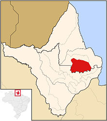
 Location of the municipality in the state of Amapá Location of the municipality in the state of Amapá
|
|||
| Symbols | |||
|
|||
| founding | 17th December 1987 (age 32) | ||
| Basic data | |||
| Country | Brazil | ||
| State | Amapá | ||
| ISO 3166-2 | BR-AP | ||
| height | 82 m | ||
| climate | tropical, Am | ||
| surface | 6,684.7 km² | ||
| Residents | 12,563 (2010) | ||
| density | 1.9 Ew. / km² | ||
| estimate | 17,315 (July 1, 2019) | ||
| Parish code | IBGE : 1600709 | ||
| Post Code | 68990-000 | ||
| Telephone code | (+55) 96 | ||
| Time zone | UTC −3 | ||
| Website | tartarugalzinho.ap (Brazilian Portuguese) | ||
| politics | |||
| City Prefect | Rildo Gomes de Oliveira (2017-2020) | ||
| Political party | MDB | ||
| economy | |||
| GDP | 187,177 thousand R $ 11,949 R $ per person (2016) |
||
| HDI | 0.592 (low) (2010) | ||
Tartarugalzinho , officially Portuguese Município de Tartarugalzinho , is a municipality in the Brazilian state of Amapá . The population was estimated as of July 1, 2019 at 17,315 inhabitants, who live on a community area of around 6684.7 km² and are called Tartarugalenses ( tartarugalenses ). It ranks 7th out of 16 municipalities in the state. The distance to the capital Macapá is around 230 km.
geography
Surrounding communities are Pracuúba in the north and northwest, Amapá in the northeast, Cutias in the southeast and Ferreira Gomes in the southwest.
The community has a tropical climate, Am according to the Köppen and Geiger climate classification . The average temperature is 26.4 ° C. The average rainfall is 2383 mm per year.
population
Of the 12,563 inhabitants according to the 2010 census, 6047, around 48%, lived in rural areas and 6516, around 52%, in urban areas. Mathematically, this results in a population density of 1.9 inhabitants per km². 41% of the population in 2010 were children and adolescents up to the age of 15.
| year | Residents |
| 1991 | 3,593 |
| 2000 | 7.121 |
| 2010 | 12,563 |
| 2019 | 17,315 |
 |
|
Ethnic composition
Ethnic groups according to the statistical classification of the IBGE (status 2010 with 12,563 inhabitants):
| group | Share (2010) | annotation |
|---|---|---|
| Brancos | 2,527 | Whites, descendants of Europeans |
| Pardos | 9,140 | Mixed races, mulattos , mestizos |
| Pretus | 769 | black |
| Amarelos | 121 | Asians |
| Indigenous people | 5 | indigenous population |
Web links
Individual evidence
- ↑ a b c Tartarugalzinho - Panorama. In: cidades.ibge.gov.br. IBGE , accessed October 23, 2019 (Brazilian Portuguese).
- ↑ Rildo Oliveira 15 (Prefeito). In: todapolitica.com. Eleições 2016, accessed October 23, 2019 (Brazilian Portuguese).
- ↑ Climate Tartarugalzinho: Weather, average temperature, weather forecast for Tartarugalzinho. In: de.climate-data.org. Retrieved October 23, 2019 .
- ^ Atlas do Desenvolvimento Humano do Brasil: Tartarugalzinho, AP. Retrieved October 23, 2019 (Brazilian Portuguese).
- ^ Sistema IBGE de Recuperação Automática - SIDRA: Tabela 2093. In: sidra.ibge.gov.br. IBGE , accessed October 23, 2019 (Brazilian Portuguese, database query, search terms Tartarugalzinho (AP) and Cor ou raça).


