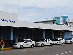
Macapá airport
| Macapá Aeroporto Internacional de Macapá Airport |
|
|---|---|

|
|
| Characteristics | |
| ICAO code | SBMQ |
| IATA code | MCP |
| Coordinates | |
| Height above MSL | 17 m (56 ft ) |
| Transport links | |
| Distance from the city center | 1 km northeast of Macapá |
| Street | BR-210 |
| Basic data | |
| operator | Infraero |
| Terminals | 1 |
| Passengers | 546,030 (2018) |
| Air freight | 3,561 t (2018) |
| Flight movements |
8,411 (2018) |
| Capacity ( PAX per year) |
2.1 million |
| Start-and runway | |
| 08/26 | 2100 m × 45 m asphalt |
The Macapa airport ( ICAO code : SBMQ , IATA code : MCP , Portuguese: Aeroporto Internacional de Macapá ) is the airport of the Brazilian city of Macapa . It is located about one kilometer northeast of the city center at an altitude of 17 meters AMSL .
Flight operations
The airport is approved for VFR as well as IFR flights. The regular opening times are from 11 am to 3 pm and 4 pm to 8 pm UTC , but night flights are also possible.
Airport facilities
The only runway runs in an east-west direction (08/26). It is 2100 meters long and has an asphalt surface. A PAPI system is available in landing direction 08 . A NDB and a VOR / DME serve as navigation aids .
There are no taxiways running parallel to the runway . In order to get to the apron south of the runway after landing , an aircraft must turn around after taxiing on the runway and roll back to one of the two taxiways branching off approximately in the middle of the runway ( backtrack ). A freight terminal and a passenger terminal are connected to the apron .
Traffic figures

| year | Passenger volume | Air freight ( tons ) (with airmail ) |
Flight movements | |||
|---|---|---|---|---|---|---|
| 2018 | 546.030 |
-5.25%
|
3,561 |
+ 10.36%
|
8,411 |
-7.44%
|
| 2017 | 576.257 |
+1.30%
|
3,227 |
+ 5.32%
|
9,087 |
-4.23%
|
| 2016 | 568,873 |
-14.74%
|
3,064 |
+0.66%
|
9,488 |
-9.71%
|
| 2015 | 667.230 |
-10.86%
|
3,044 |
-27.25%
|
10,508 |
-22.77%
|
| 2014 | 748.480 |
+ 12.80%
|
4.184 |
+ 10.42%
|
13,606 |
-2.28%
|
| 2013 | 663.524 |
+ 15.69%
|
3,789 |
+1.61%
|
13,924 |
+ 10.75%
|
| 2012 | 573,560 |
+ 2.36%
|
3,729 |
-6.80%
|
12,572 |
-1.41%
|
| 2011 | 560.317 |
+ 3.37%
|
4,001 |
+ 8.96%
|
12,752 |
-6.60%
|
| 2010 | 542.053 |
+ 15.37%
|
3,672 |
-4.55%
|
13,653 |
+ 13.22%
|
| 2009 | 469.836 |
-4.89%
|
3,847 |
+1.83%
|
12,059 |
-11.42%
|
| 2008 | 493.999 |
-6.19%
|
3,778 |
+ 2.00%
|
13,613 |
+ 6.18%
|
| 2007 | 526.570 |
+ 9.62%
|
3,704 |
-0.07%
|
12,821 |
-0.95%
|
| 2006 | 480,377 | 3,706 | 12,944 | |||
- ↑ From 2010, transit freight will also be taken into account.
Web links
- Official website (Portuguese)
- Official website of the operating company Infraero (Portuguese)
- Airport data on World Aero Data ( 2006 )
- Airport data in the Aviation Safety Network (English)
Individual evidence
- ↑ a b Características. Infraero.gov.br , accessed October 21, 2018 (Portuguese).
- ↑ a b c d e Estatísticas. Infraero.gov.br , accessed August 15, 2019 (Portuguese).
- ↑ a b c d e Departamento de Controle do Espaço Aéreo: AIP Brazil, AD 2 SBMQ 1–8 , as of July 28, 2011
- ↑ Database query on the official IATA website ( Memento of the original from July 21, 2011 in the Internet Archive ) Info: The archive link was inserted automatically and has not yet been checked. Please check the original and archive link according to the instructions and then remove this notice. , carried out on November 20, 2011
- ↑ Departamento de Controle do Espaço Aéreo: ADC-SBMQ (airport diagram ), as of September 22, 2011