Santana (Amapá)
| Município de Santana Santana |
|||
|---|---|---|---|
|
Porto de Santana, Amapá
|
|||
|
|
|||
| Coordinates | 0 ° 2 ′ S , 51 ° 11 ′ W | ||
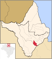
 Location of the municipality in the state of Amapá Location of the municipality in the state of Amapá
|
|||
| Symbols | |||
|
|||
| founding | February 4, 1758 (as Vila de São José de Macapá) December 17, 1987 (as the city of Santana) |
||
| Basic data | |||
| Country | Brazil | ||
| State | Amapá | ||
| ISO 3166-2 | BR-AP | ||
| Região intermediária | Macapá (since 2017) | ||
| Região imediata | Macapá (since 2017) | ||
| Metropolitan area | Macapá | ||
| structure | 6 districts (as of 2015) | ||
| height | 15 m | ||
| Waters | Rio Amazonas , Rio Matapi | ||
| climate | Af, equatorial | ||
| surface | 1,541.2 km² | ||
| Residents | 101,262 (2010) | ||
| density | 65.7 Ew. / km² | ||
| estimate | 121,364 (July 1, 2019) | ||
| Time zone | UTC −3 | ||
| Website | santana.portal.ap (Brazilian Portuguese) | ||
| politics | |||
| City Prefect | Ofirney Sadala (2017-2020) | ||
| Political party | Partido Social Democrata Cristão (PSDC) | ||
| HDI | 0.692 (2010) | ||
Santana , officially Município de Santana , is the second most populous city in the Brazilian state of Amapá in the Região Norte . It is 30 km from the capital Macapá . The population was estimated on July 1, 2019 at 121,364 inhabitants, called Santanese (Portuguese santanenses ), who live in an area of around 1541 km². The population density is 64 people per km².
Santana forms a conurbation with Macapá , the Macapá metropolitan area comprised around 600,000 inhabitants in 2016.
geography
The landscape is mixed with Brazilian Cerrado and Várzea with tropical and subtropical moist deciduous forests, the climate is according to the Köppen and Geiger Af climate classification . The average temperature is 28 ° C.
The town and municipality are under the influence of various large rivers and smaller watercourses (igarapé): Rio Amazonas , Rio Matapi , Rio Maruanum , Rio Tributário , Rio Piaçacá , Rio Vila Nova , Igarapé do Lago and Igarapé Fortaleza.
Surrounding places are Macapá (30 km away) and Mazagão to the south.
history
As early as February 4, 1758, the village of Vila de São José de Macapá , which was opposite the Ilha de Santana on the Amazon, was founded in the then Estado do Grão-Pará e Maranhão by Captain-General Francisco Xavier de Mendonça Furtado .
It was under the municipality of Macapá in the 19th and 20th centuries and was appointed to the District of Santana on August 31, 1981 with Francisco Correa Nobre as the first district agent.
By decree (No. 7639) of December 17, 1987, the district was spun off and raised to an independent Munizip, on July 1, 1988, the governor of Amapá, Jorge Nova da Costa, appointed Heitor de Azevedo Picanço as the first interim prefect. The first direct elections by the citizens took place on December 15, 1988, with Rosemiro Rocha Freires winning the mandate as city prefect.
City administration
Executive: In the municipal election in 2016 was Ofirney Sadala prefect (mayor) for the period 2017-2020, of the Partido Social Democrata Cristão came into office (PSDC). He has appointed two of his siblings to high offices in the city.
The legislature rests with a 16-member city council, the vereadores of the Câmara Municipal, and in 2017 the presidency was held by Helena Pereira de Lima, a member of the Partido Republicano Progressista (PRP).
Santanta is divided into six districts: Santana (seat), Anauerapucu, Igarapé do Lago, Ilha de Santana, Piaçacá and Pirativa.
Population development
Source: IBGE (2018 figures are only estimates). In 2010, 33% of the population were children and young people up to the age of 15. In 2010, 97.88% lived in urban areas and 2.12% in extensive rural areas. Santana is the smallest municipality in Amapá in terms of area. In 2010, the illiteracy rate among adults over the age of 25 was 13.55%. Since the last census in 2010, the population has grown by over 18,000.

Standard of living
The human development index for cities, abbreviated HDI (Portuguese: IDH-M ), was in 1991 at the low value of 0.426 in 2010 at the medium high value of 0.692.
economy
Santa owns the port of Porto de Santana , through which iron and manganese ores and wood are shipped from the hinterland. The goods used to be brought to Santana on the Estrada de Ferro Amapá railway line . From the port there is also passenger traffic up the Amazon inland.
Sports
The football club Santana EC (Santana Esporte Clube) has won the title at the Amapá State Championship seven times .
Web links
- City Prefecture website , Prefeitura Municipal (Brazilian Portuguese)
- City Council website , Câmara Municipal (Brazilian Portuguese)
Individual evidence
- ↑ a b c d Instituto Brasileiro de Geografia e Estatística (IBGE): Amapá: Santana> Panorama. Retrieved August 17, 2018 (Brazilian Portuguese).
- ↑ Ofirney Sadala. In: com.br. Eleições 2016, accessed January 26, 2018 (Portuguese).
- ↑ Prefeito de Santana, no AP, nomeia irmãos para ocupar secretarias . In: O Globo G1 . January 3, 2017 (Brazilian Portuguese, globo.com [accessed January 26, 2018]).
- ^ A b Atlas do Desenvolvimento Humano do Brasil: Santana - AP. Retrieved January 26, 2018 (Portuguese).


