
Oiapoque
| Município de Oiapoque "Capital do Norte Amapaense"
Oiapoque
"Princesa do Rio Oiapoque" |
|||
|---|---|---|---|
 Center of Oiapoque
|
|||
|
|||
| Coordinates | 3 ° 49 ′ N , 51 ° 49 ′ W | ||
 Location of the municipality in the state of Amapá Location of the municipality in the state of Amapá
|
|||
| Symbols | |||
|
|||
| founding | 23rd May 1945 (age 468) | ||
| Basic data | |||
| Country | Brazil | ||
| State | Amapá | ||
| ISO 3166-2 | BR-AP | ||
| structure | 3 districts since 1960: Oiapoque, Clevelândia do Norte, Vila Velha | ||
| height | 10 m | ||
| Waters | Rio Oiapoque | ||
| climate | tropical, Am | ||
| surface | 23,034.4 km² | ||
| Residents | 20,509 (2010) | ||
| density | 0.9 Ew. / km² | ||
| estimate | 27,270 (July 1, 2019) | ||
| Parish code | IBGE : 1600501 | ||
| Post Code | 68980-000 | ||
| Telephone code | (+55) 96 | ||
| Time zone | UTC −3 | ||
| Website | oiapoque.ap (Brazilian Portuguese) | ||
| politics | |||
| City Prefect | Maria Orlanda Marques Garcia (2017-2020) | ||
| Political party | PSDB | ||
| Culture | |||
| Patron saint | Mother of Jesus as Nossa Senhora das Graças | ||
| economy | |||
| GDP | 353,442 thousand R $ 14,199 R $ per person (2016) |
||
| HDI | 0.658 (medium) (2010) | ||
 Border bridge
|
|||


Oiapoque , officially Portuguese Município de Oiapoque , is a small town with a large municipality in the far north of Brazil in the state of Amapá . The population was estimated on July 1, 2019 at 27,270 inhabitants, the Oiapoquenser ( oiapoquenses ) are called and live in a municipality of around 23,034.4 km², the second largest area of the 16 municipalities of the state. It is economically important as a border town to French Guiana , from which the city is separated by the Oiapoque River . The distance to the capital Macapá is 550 km.
history
Although the region was visited by European sailors as early as the 16th century, until well into the 19th century it was practically only inhabited by the Waiãpi Indians, from whose language the name of the community comes. Not much is known about this period, except that the first village in the area was named Martinica after the first white settler Emile Martinic. In 1907, the Brazilian government established a penal colony for political prisoners, the Colônia Militar , in the municipality, which was later concentrated in the military base in the Clevelândia do Norte district that still exists today .
It was not until May 23, 1945 that the community was finally established and the previous zone was spun off from the Amapá municipality , which was the capital of the newly founded state at the time.
In the historical and geographical literature, the toponym experienced numerous spelling variants, including Guayapoco, Hiapoco, Iapoc, Iapoco, Japoc, Japoco, Oiapoc, Ojapoc, Ouarypoco, Ouayapoco, Oujapoc, Ouyapoc, Ouiyapok, Ouayapoco, Ouiyapoco, Ouayapoco, Ouyapok, Ouayapoco, Ouyapoko or Oyapok.
East of the main town and upstream are the Indian sanctuaries Terra Indígena Galibi and Terra Indígena Uaçá (I and II) with around 7,000 and 470,000 hectares, respectively, in which the mainland caribs Galibi de Oiapoque , Galibi-Marworno and Karipuna as well as the arawak-speaking Palikur live. In the east, the Cabo Orange National Park (Parque Nacional Cabo Orange) is also part of the municipality. The Tumucumaque National Park connects to the southwest . The biome is predominantly tropical lowland rainforest .
geography
Surrounding communities are Serra do Navio , Calçoene , Laranjal do Jari , Pedra Branca do Amapari and São Jorge do Oiapoque in French Guiana.
climate
The community has a tropical climate, Am according to the Köppen and Geiger climate classification . The average temperature is 25.9 ° C. The average rainfall is 3309 mm per year.
Average monthly temperatures and rainfall for Oiapoque
| Jan | Feb | Mar | Apr | May | Jun | Jul | Aug | Sep | Oct | Nov | Dec | |||
| Temperature ( ° C ) | 25.4 | 25.0 | 25.7 | 25.6 | 25.8 | 25.8 | 26.0 | 26.4 | 26.5 | 26.5 | 26.3 | 25.7 | O | 25.9 |
| Precipitation ( mm ) | 395 | 345 | 396 | 450 | 537 | 370 | 193 | 102 | 48 | 44 | 116 | 313 | Σ | 3309 |
Administrative division
The municipality is divided into the small urban main town of Oiapoque with an area of 2.43 km² and since 1960 in addition to the surrounding main district in two further districts: Clevelândia do Norte and Vila Velha. In comparison, this individual municipality is roughly the same size as the state of Mecklenburg-Western Pomerania .
From 1989 to 2017 it belonged to the geostatistical mesoregion of the Brazilian statistical office Norte de Amapá and to the microregion Oiapoque , to which the town of Calçoene also belonged.
City administration
Since the local elections in 2016, Maria Orlanda Marques Garcia of the Partido da Social Democracia Brasileira (PSDB), who replaced the predecessor Miguel Caetano de Almeida of the Partido Socialista Brasileiro (PSB), has been city prefect for the 2017 to 2020 term of office .
The legislature rests with an 11-member city council, and José Nazareno Rodrigues, known as Lobão , was elected President for 2017 .
population
Of the 20,509 inhabitants in 2010 according to the census, 8,857 lived in rural areas and 13,852, around 67.5%, in urban areas. Around 36.7% of the population in 2010 were children and adolescents up to the age of 15.
| year | Residents |
| 1991 | 7,555 |
| 2000 | 12,886 |
| 2010 | 20,509 |
| 2019 | 27,270 |
 |
|
Ethnic composition
Ethnic groups according to the statistical classification of the IBGE (status 2010 with 20,509 inhabitants):
| group | Share (2010) | annotation |
|---|---|---|
| Brancos | 3.114 | Whites, descendants of Europeans |
| Pardos | 10,490 | Mixed races, mulattos , mestizos |
| Pretus | 1,197 | black |
| Amarelos | 150 | Asians |
| Indigenous people | 5,557 | indigenous population |
Economy and Infrastructure
The city's economy is based on agriculture, especially the cultivation of tropical plants and livestock, the largely illegal gold mining and trade with French Guiana, which is part of the EU .
Oiapoque is connected to the Brazilian road network via the BR-156 , which, however, has not yet been completely paved. It can be reached from Saint-Georges-de-l'Oyapock on the French side of the river by boat and, since 2017, also with the bridge over the Oyapock .
Since prices are below those of French Guiana, especially after the opening of the road from Saint-Georges to Régina in 2004, the city became a shopping center for the residents of Cayenne and other cities of the French territory.
Bridge over the Rio Oiapoque
The first direct road link between France and Brazil has existed via a bridge since August 2011, although it was only opened to pedestrian and car traffic in March 2017. Before that, there was no traffic clearance due to work on the access road and a missing customs post, it either had to be crossed by ships or a detour via Suriname and Guyana was necessary. For French Guiana, the bridge has great development potential because the territory which so far has only small harbors so much better with the deep-water port of Santana will be connected, which in particular with the ESA -Weltraumbahnhof Guiana Space Center in Kourou related industry will benefit.
Since the completion of the bridge, there has been a road connection on the northeast coast of South America, interrupted by two ferries, to Guyana . In the Guyana National Development Strategy 2001-2010 , which was adopted in 2000, it was planned to extend this road to the west and connect Guyana and Venezuela by a bridge over the Cuyuní . Due to the border dispute between Guyana and Venezuela , this intention will not be realized in the foreseeable future.
Social situation
One of the problems of the city is the poorly developed infrastructure, especially the inadequate supply of electrical energy due to severe energy management problems in Amapá, which led to a long failure of the regular power supply in 2006/2007. Health care is also precarious. Another problem is illegal prostitution , including that of children and young people .
Average income and standard of living
The monthly average income in 2017 was a factor of 1.9 of the Brazilian minimum wage ( Salário mínimo ) of R $ 880.00 (converted for 2019: around € 360).
The gross national product per capita in 2016 was R $ 14,199.
The human development index for cities, abbreviated HDI (Portuguese: IDH-M ) was in 1991 at the low value of 0.388, in 2010 at the medium high value of 0.658. The lack of educational structure is decisive for the low value.
| HDI | ||||
|---|---|---|---|---|
| year | Points | |||
| 1991 | 0.388 | |||
| 2000 | 0.537 | |||
| 2010 | 0.658 | |||
Illiteracy rate
Oiapoque had an illiteracy rate of 28.2% in 1991 , which had already fallen to 12.25% in the 2010 census.
| Illiteracy rate | ||||
|---|---|---|---|---|
| year | percent | |||
| 1991 | 28.20 | |||
| 2000 | 22.00 | |||
| 2010 | 12.25 | |||
photos

Igreja Nossa Senora das Graças Church (2010)

Street view, on the right Igreja Nossa Senora das Graças (2006)
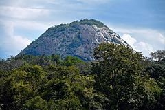
Monte Karupina in the Uaçá Indian sanctuary


literature
- Maria Irene de Conte: A ponte sobre o rio Oiapoque: uma ponte 'transoceânica' entre o Brasil ea França; o Mercosul ea União Européia? (PDF file; 2.1 MB), University of São Paulo, April 16, 2008.
Web links
- City Prefecture website , Prefeitura Municipal (Brazilian Portuguese)
- City Council website , Câmara Municipal (Brazilian Portuguese)
Individual evidence
- ↑ a b Climate Oiapoque: Weather, average temperature, weather forecast for Oiapoque. In: de.climate-data.org. Retrieved October 22, 2019 .
- ↑ a b c Oiapoque - Panorama. In: cidades.ibge.gov.br. IBGE , accessed October 22, 2019 (Brazilian Portuguese).
- ^ Amapá: Oiapoque: História. In: cidades.ibge.gov.br/brasil. IBGE , accessed October 22, 2019 (Brazilian Portuguese, brief city history).
- ↑ Terra Indígena Uaçá I e II. In: terrasindigenas.org.br. Terras Indígenas no Brasil, Instituto Socioambiental, accessed October 22, 2019 (Brazilian Portuguese).
- ↑ Maria 45 Orlanda (Prefeita). In: todapolitica.com. Eleições 2016, accessed October 22, 2019 (Brazilian Portuguese).
- ^ Lobão - Câmara Municipal de Oiapoque. In: www.oiapoque.ap.leg.br. Câmara Municipal, accessed October 22, 2019 (Brazilian Portuguese).
- ↑ a b c Atlas do Desenvolvimento Humano do Brasil: Oiapoque - AP. Retrieved October 22, 2019 (Brazilian Portuguese).
- ↑ Sistema IBGE de Recuperação Automática - SIDRA: Tabela 2093. In: https://sidra.ibge.gov.br . IBGE , accessed on October 22, 2019 (Brazilian Portuguese, database query, search terms Oiapoque (AP) and Cor ou raça).
- ↑ Génèse du projet de pont sur l'Oyapock - Historique du projet. ( Memento of the original from August 12, 2014 in the Internet Archive ) Info: The archive link was inserted automatically and has not yet been checked. Please check the original and archive link according to the instructions and then remove this notice. Direction Départementale de l'Equipement de la Guyane (French)
- ↑ First border bridge between the EU and South America opened. FAZ , March 18, 2017, accessed on March 18, 2017 .
- ↑ Graziela Miranda: Ponte de R $ 61 milhões aguarda inauguração há dois anos no Amapá. O Globo , June 7, 2013, accessed March 18, 2017 (Portuguese).
- ↑ Conte, p. 34 ff.
- ↑ National Development Strategy , Chapter 8: Transport , No. 8.IV.1.14 ( Memento of the original dated April 28, 2009 in the Internet Archive ) Info: The archive link was inserted automatically and has not yet been checked. Please check the original and archive link according to the instructions and then remove this notice. (English).
- ↑ Conte, p. 53 ff.
- ↑ Conte, p. 67 ff.
Região geográfica intermediária and Região geográfica imediata
|
Macapá code: 1601 |
|
|||||
|
Oiapoque-Porto Grande Code: 1602 |
|

| Mesoregion North Amapá |
Amapá microregion: Amapá | Pracuúba | Tartarugalzinho | Microregion Oiapoque: Calçoene | Oiapoque |
|
| South Amapá mesoregion |
Macapá microregion: Cutias | Ferreira Gomes | Itaubal | Macapá | Pedra Branca do Amapari | Porto Grande | Santana | Serra do Navio | Mazagão Microregion: Laranjal do Jari | Mazagão | Vitória do Jari |