
Mazagao (Amapá)
| Município de Mazagão Mazagão |
|||
|---|---|---|---|
|
|||
| Coordinates | 0 ° 7 ′ S , 51 ° 17 ′ W | ||

|
|||
| Symbols | |||
|
|||
| Basic data | |||
| Country | Brazil | ||
| State | Amapá | ||
| ISO 3166-2 | BR-AP | ||
| Região intermediária | Macapá (since 2017) | ||
| Região imediata | Macapá (since 2017) | ||
| Metropolitan area | Macapá | ||
| structure | 3 districts, 17 settlements | ||
| height | 60 m | ||
| Waters | Rio Amazonas , Rio Mutuacá | ||
| climate | Af, equatorial | ||
| surface | 13,294.8 km² | ||
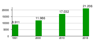
| Residents | 17,032 (2010) | ||
| density | 1.3 Ew. / km² | ||
| estimate | 21,206 (July 1, 2018 ) | ||
| Parish code | IBGE : 1600402 | ||
| Telephone code | (+) 55 (96) | ||
| Time zone | UTC −3 | ||
| Website | www.mazagao.ap.gov.br (Brazilian Portuguese) | ||
| politics | |||
| City Prefect | João da Silva Costa (2017-2020) | ||
| Political party | Partido Pátria Livre (PPL) | ||
| Culture | |||
| Patron saint | Nossa Senhora da Assunção | ||
| economy | |||
| GDP | 201,204 thousand R $ 10,281 R $ per capita (2015) |
||
| HDI | 0.592 (2010) | ||


Mazagão , officially Município de Mazagão , is the fifth most populous city in the Brazilian state of Amapá in the Região Norte . It is located on the left bank of the Amazon and is around 34 km from the capital Macapá . The population was estimated on July 1, 2018 at 21,206 inhabitants, called Mazanganese (Portuguese mazaganense or mazaganistas ), who live in an area of around 13,295 km². The population density was 1.3 in 2010 and 1.5 people per km² in 2017.
geography
The landscape is mixed with Brazilian Cerrado and Várzea with tropical and subtropical moist deciduous forests, the climate is tropical according to the climate classification according to Köppen and Geiger Am / Af . The average temperature is 27 ° C. There is a lot of precipitation and few dry spells.
At Mazagão the Amazon widens and forms several river islands, the largest at Mazagão is the Ilha do Pará . To the north, the Rio Vila Novo forms the border with Santana; to the south, the Rio Mazagão , via which one arrives at the founding place Mazagão Velho , flows into the Amazon. In the south, around 5017 square kilometers located Nutzreservat Reserva extrativista do Rio Cajari .
Surrounding places are Pedra Branca do Amapari , Porto Grande , Santana , Vitória do Jari and Laranjal do Jari .
In 2017, the Instituto Brasileiro de Geografia e Estatística changed the assignment to geostatistical regions and assigned the municipality to the Região geográfica imediata Macapá and the Região geográfica intermediária Macapá . With Santana and Macapá, Mazagão is part of the Macapá metropolitan area .
history
The city was founded in 1769 as Nova Mazagão by the Portuguese, whose hometown Mazagão (today: El Jadida ) in northwest Africa came into the possession of the Moors.
City administration
Executive: In the local elections in 2016, João da Silva Costa, known as Professor Dudão , became city prefect (mayor) for the term from 2017 to 2020, who ran for the Partido Pátria Livre (PPL).
The legislature rests with an 11-member city council, the vereadores of the Câmara Municipal.
Population development
Source: IBGE (2018 figures are only estimates). 41.39% of the population in 2010 were children and adolescents up to the age of 15. In 2010, 48.57% lived in urban areas and 51.43% in extensive rural areas. Mazagão is the fifth largest municipality in Amapá in terms of area. In 2010, the illiteracy rate among adults over the age of 25 was 29.3%.
Standard of living
The human development index for cities, abbreviated HDI (Portuguese: IDH-M ), was at the very low value of 0.319 in 1991, at the low value of 0.592 in 2010.
The monthly average income per person is given as R $ 353.61 , which corresponds to a value of 90.30 euros in 2018.
traffic
The AP-010 provincial road runs through Mazagão . The nearest airport is Aeroporto Internacional de Macapá Airport , 30.2 km away.
literature
- Augusto Ferreira do Amaral: Mazagão. A epopeia portuguesa in Morocco. Fundação Oriente e Comissão Portuguesa de História Militar, Lisboa 2007, ISBN 978-972-8799-56-4 .
Web links
- City Prefecture website , Prefeitura Municipal (Brazilian Portuguese)
- IBGE: Mazagão> Panorama , current statistics (Brazilian Portuguese)
- Governo do Estado do Amapá, Secretaria de Estado do Planejamento: Síntese de informações socioeconômicas do município Mazagão. SEPLAN, Amapá 2017 (Brazilian Portuguese)
Individual evidence
- ↑ a b IBGE : Amapá: Mazagão> Panorama. Retrieved September 20, 2018 (Brazilian Portuguese).
- ↑ a b Estimativas da população residente no Brasil e unidades da federação com data de referência em 1 ° de julho de 2018. (PDF; 2.6 MB) In: ibge.gov.br. IBGE , 2018, accessed September 20, 2018 (Brazilian Portuguese).
- ↑ Mazagão climate: average temperature, weather by month, Mazagão weather averages. In: climate-data.org. de.climate-data.org, accessed on January 28, 2018 .
- ↑ Instituto Brasileiro de Geografia e Estatística (IBGE): Divisão Regional do Brasil. 2017, accessed January 28, 2017 .
- ↑ population history . In: Richard Konetzke : South and Central America I. The Indian cultures of ancient America and the Spanish-Portuguese colonial rule (= Fischer Weltgeschichte . Volume 22). Fischer Taschenbuch, Frankfurt am Main 1965, p. 73.
- ↑ Professor Dudão. In: com.br. Eleições 2016, accessed January 28, 2018 (Brazilian Portuguese).
- ↑ a b c Atlas do Desenvolvimento Humano do Brasil: Mazagão - AP. Retrieved January 28, 2018 (Brazilian Portuguese).
Região geográfica intermediária and Região geográfica imediata
|
Macapá code: 1601 |
|
|||||
|
Oiapoque-Porto Grande Code: 1602 |
|
