Itaubal
| Município de Itaubal "Itaubal do Piririm"
Itaubal
|
|||
|---|---|---|---|
|
|
|||
| Coordinates | 0 ° 36 ′ N , 50 ° 40 ′ W | ||
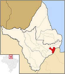
 Location of Itaubal in the state of Amapá Location of Itaubal in the state of Amapá
|
|||
| Symbols | |||
|
|||
| founding | May 1, 1992 | ||
| Basic data | |||
| Country | Brazil | ||
| State | Amapá | ||
| ISO 3166-2 | BR-AP | ||
| Região intermediária | Macapá (since 2017) | ||
| Região imediata | Macapá (since 2017) | ||
| height | 8 m | ||
| climate | Af, tropical | ||
| surface | 1,622.9 km² | ||
| Residents | 4265 (2010) | ||
| density | 2.6 Ew. / km² | ||
| estimate | 5503 (July 1, 2019) | ||
| Parish code | IBGE : 1600253 | ||
| Time zone | UTC −3 | ||
| Website | www.itaubal.ap.gov.br (Brazilian Portuguese) | ||
| politics | |||
| City Prefect | Victor Hugo Lopes Rodrigues (2017-2020) | ||
| Political party | Partido do Movimento Democrático Brasileiro (PMDB) | ||
| economy | |||
| GDP | 30,375 thousand R $ 8477 R $ per person (2008) |
||
| HDI | 0.576 (2010) | ||
Itaubal , officially Portuguese Município de Itaubal , is a small town in the Brazilian state of Amapá in the Região Norte . It is located on the Amazon delta and is around 80 km from the capital Macapá . The population was estimated on July 1, 2019 at 5503 inhabitants. The inhabitants who live in the approximately 1,623 km² area are called Itaubenses (Portuguese itaubenses ). The population density in 2010 was 2.6 people per km².
geography
The landscape and biome are predominantly shaped by the Amazon rainforest . In the south, the municipality is bounded by the Amazon Delta. The climate is tropical according to the Köppen and Geiger Am / Af climate classification . The average temperature is 27 ° C. There is a lot of precipitation and few dry spells.
history
In 1988 the settlement became a district of Macapá, in 1991 there was a referendum to become independent, which on May 1, 1992 led to the city being founded as a municipality .
In 2017, the Instituto Brasileiro de Geografia e Estatística changed the assignment to geostatistical regions and assigned the municipality to the Região geográfica imediata Macapá and the Região geográfica intermediária Macapá .
City administration
Executive: In the local elections in 2016, Victor Hugo Lopes Rodrigues became city prefect (mayor) for the term from 2017 to 2020, who ran for the Partido do Movimento Democrático Brasileiro (PMDB).
Standard of living
The human development index for cities, abbreviated HDI (Portuguese: IDH-M ), was at the very low value of 0.268 in 1991, at the low value of 0.415 in 2000 and at the low value of 0.576 in 2010.
Population development
| year | Residents | city | country |
|---|---|---|---|
| 1991 | 1.003 | 340 | 663 |
| 2000 | 2,894 | 1,156 | 1,738 |
| 2010 | 4,265 | 1,754 | 2,511 |
| 2019 | 5,503 | ? | ? |
 |
|||
Source: IBGE (2011)
Ethnic composition
Ethnic groups according to the statistical classification of the IBGE (status 2000 with 2894 inhabitants, status 2010 with 4265 inhabitants):
| group | Share 2000 |
Share 2010 |
annotation |
|---|---|---|---|
| Brancos | 420 | 748 | Whites, descendants of Europeans |
| Pardos | 1,556 | 3,144 | Mixed races, mulattos , mestizos |
| Pretus | 712 | 323 | black |
| Amarelos | 4th | 42 | Asians |
| Indigenous people | 23 | 7 | indigenous population |
| without specification | 179 | - |
Source: SIDRA
Web links
- City Prefecture website , Prefeitura Municipal (Brazilian Portuguese)
- Instituto Brasileiro de Geografia e Estatística (IBGE): Itaubal> Panorama , updated statistics (Brazilian Portuguese)
Individual evidence
- ↑ a b c d Instituto Brasileiro de Geografia e Estatística (IBGE): Amapá: Itaubal> Panorama. Retrieved September 1, 2019 (Brazilian Portuguese).
- ↑ a b Dr Victor 15. In: com.br. Eleições 2016, accessed April 5, 2018 (Brazilian Portuguese).
- ↑ Climate Itaubal: weather, climate table & climate diagram. In: climate-data.org. de.climate-data.org, accessed on April 5, 2018 .
- ↑ Instituto Brasileiro de Geografia e Estatística (IBGE): Divisão Regional do Brasil. 2017, accessed on January 28, 2017 (URL available via downloads in table format).
- ^ A b Atlas do desenvolvimento humano no Brasil - Itaubal . Retrieved April 1, 2020 (Brazilian Portuguese).
- ↑ IBGE : Sistema IBGE de Recuperação Automática - SIDRA: Tabela 2093. Retrieved on April 1, 2020 (Portuguese, database query, search terms Itaubal and Cor ou raça).


