Serra do Navio
| Município de Serra do Navio Serra do Navio |
|||
|---|---|---|---|
|
|
|||
| Coordinates | |||
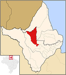
 Location of the municipality in the state of Amapá Location of the municipality in the state of Amapá
|
|||
| Symbols | |||
|
|||
| founding | 17th March 1992 (age 28) | ||
| Basic data | |||
| Country | Brazil | ||
| State | Amapá | ||
| ISO 3166-2 | BR-AP | ||
| height | 148 m | ||
| Waters | Rio Amapari | ||
| climate | tropical, Am | ||
| surface | 7713 km² | ||
| Residents | 4380 (2010) | ||
| density | 0.6 Ew. / km² | ||
| estimate | 5397 (July 1, 2019) | ||
| Parish code | IBGE : 1600154 | ||
| Post Code | 68948-000 | ||
| Telephone code | (+55) 96 | ||
| Time zone | UTC −3 | ||
| Website | serradonavio.ap (Brazilian Portuguese) | ||
| politics | |||
| City Prefect | Elson Belo Lobato (2017-2020) | ||
| Political party | PTdoB | ||
| economy | |||
| GDP | 64,649 thousand R $ 12,865 R $ per person (2016) |
||
| HDI | 0.709 (high) (2010) | ||
Serra do Navio , officially Portuguese Município de Serra do Navio , is a municipality in the Brazilian state of Amapá . The population was estimated on July 1, 2019 at 5397 inhabitants, who live on a municipal area of around 7713 km² and are called Serranavienser ( serranavienses ). It ranks 14th out of 16 municipalities in the state. The distance to the capital Macapá is around 141 km. It is known for its manganese findings .
geography
Surrounding communities are Oiapoque , Calçoene , Pracuúba , Pedra Branca do Amapari and Ferreira Gomes . The place Serra do Navio is located at the southern end of the municipality and on the left side of the Rio Amapari , which drains into the Atlantic. The biome is tropical rainforest .
The community has a tropical climate, Af according to the Köppen and Geiger climate classification . The average temperature is 26.1 ° C. The average rainfall is 2456 mm per year.
history
The place was initially called Água Branca do Amapari and was spun off from Macapá on March 17, 1992 as a separate municipality. The name was changed to Serra do Navio on June 22, 1993.
population
Of the 4380 inhabitants according to the 2010 census, 1805 lived in rural areas and 2575, around 59%, in urban areas. Mathematically, this results in a population density of 0.6 inhabitants per km². Around 36.6% of the population in 2010 were children and young people up to the age of 15.
| year | Residents |
| 1991 | 1,838 |
| 2000 | 3,293 |
| 2010 | 4,380 |
| 2019 | 5,397 |
 |
|
Ethnic composition
Ethnic groups according to the statistical classification of the IBGE (status 2010 with 4380 inhabitants):
| group | Share (2010) | annotation |
|---|---|---|
| Brancos | 1,089 | Whites, descendants of Europeans |
| Pardos | 3,093 | Mixed races, mulattos , mestizos |
| Pretus | 195 | black |
| Amarelos | 3 | Asians |
| Indigenous people | 0 | indigenous population |
In the 2000 census, 33 indigenous people were recorded.
sons and daughters of the town
- Fernanda Takai (* 1971), singer
Web links
Individual evidence
- ↑ a b c Serra do Navio - Panorama. In: cidades.ibge.gov.br. IBGE , accessed October 24, 2019 (Brazilian Portuguese).
- ↑ Elson 70 70 (Prefeito). In: todapolitica.com. Eleições 2016, accessed October 24, 2019 (Brazilian Portuguese).
- ↑ José Augusto Drummond, Mariângela de Araújo Pereira: O Amapá nos tempos do manganês. O estudo sobre o desenvolvimento de um estado amazônico - 1943-2000 . Garamond, Rio de Janeiro 2007, ISBN 978-85-7617-118-8 , pp. 381–459 (Brazilian Portuguese, limited preview in Google Book Search).
- ↑ Climate Serra do Navio: Weather, average temperature, weather forecast for Serra do Navio. In: de.climate-data.org. Retrieved October 24, 2019 .
- ↑ Serra do Navio - História. In: cidades.ibge.gov.br. IBGE , accessed October 24, 2019 (Brazilian Portuguese).
- ^ Atlas do Desenvolvimento Humano do Brasil: Pedra Branca do Amapari, AP. Retrieved October 24, 2019 (Brazilian Portuguese).
- ^ Sistema IBGE de Recuperação Automática - SIDRA: Tabela 2093. In: sidra.ibge.gov.br. IBGE , accessed October 23, 2019 (Brazilian Portuguese, database query, search terms Serra do Navio (AP) and Cor ou raça).


