Roraima
| Estado de Roraima Roraima |
|||
|---|---|---|---|
|
|
|||
| Coordinates | 2 ° N , 61 ° W | ||
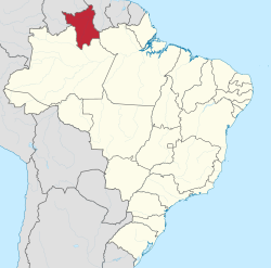
 Location of the state of Roraima in Brazil Location of the state of Roraima in Brazil
|
|||
| Symbols | |||
|
|||
| founding | 1988 (previously 1943–1988 Territorio Federal do Rio Branco) |
||
| Basic data | |||
| Country | Brazil | ||
| State | Roraima | ||
| Capital | Boa Vista | ||
| ISO 3166-2 | BR-RR | ||
| Região intermediária | 2 (since 2017) | ||
| Região imediata | 4 (since 2017) | ||
| structure | 15 municipalities | ||
| Waters | Rio Branco | ||
| climate | equatorial, Aw, Am | ||
| surface | 224,300.8 km² | ||
| Residents | 450,479 (2010, last census ) | ||
| density | 2 Ew. / km² | ||
| estimate | 605,761 Ew. (July 1, 2019) | ||
| Time zone | UTC −4 | ||
| Website | portal.rr.gov.br (Brazilian Portuguese) | ||
| politics | |||
| governor |
Antonio Denarium ( PSL ) Vice-Governor : Frutuoso Lins ( PTC ) National MEPs : 24 (January 1, 2019) |
||
| economy | |||
| GDP | 9,744 billion R $ 19,608 R $ per capita (2014) |
||
| HDI | 0.707 (2010) | ||
Roraima , officially Portuguese Estado de Roraima , is the least populous of the 27 states of Brazil and is located in the north of the greater Norte region . First as a federal territory set up by the central government in 1943 and subordinate to it ( Território Federal do Rio Branco ), Roraima was elevated to a federal state in 1988. The capital of Roraima is Boa Vista , it is the only Brazilian capital that is entirely in the northern hemisphere .
geography
Roraima borders the Brazilian states of Pará and Amazonas as well as Venezuela and Guyana .
Much of the state is covered in tropical rainforest . A small savannah area extends to the east . One of the highest mountains in Brazil and the namesake of the state, the Roraima-Tepui , is located in the Roraima National Park .
Demographics
According to the 2000 census of the Instituto Brasileiro de Geografia e Estatística (IBGE), Roraima had 324,397 inhabitants on an area of around 224,300 km². The population density was 1.45 inhabitants per km².
The last census of 2010 showed a population of 450,479 people on an area of around 224,301 km² and a population density of 2.09 inhabitants per km².
More recent estimates of the population were published by the IBGE on July 1, 2019.
2000 census |
2010 census |
Estimated July 1, 2019 |
Area 2018 km 2 |
More information |
|---|---|---|---|---|
| 324.397 | 450,479 | 605.761 | 224,273.831 |
Cities
Roraima has a total of 15 cities with large municipal areas that have the status of a município (Munizip) according to Brazilian municipal law.
The three largest cities are: Boa Vista as the only large city and the highest annual increase (2018 estimated: 375,374 inhabitants), Rorainópolis (2018 estimated: 29,533 inhabitants) and Caracaraí (2018 estimated: 21,564 inhabitants), which replaced Alto Alegre in the ranking .
Web links
- Roraima Government Portal (Brazilian Portuguese)
- Government Portal Transpârencia (Brazilian Portuguese)
Individual evidence
- ↑ a b c d IBGE : Roraima - Panorama . Retrieved September 5, 2019 (Brazilian Portuguese).
- ^ John Hemming: How Brazil Acquired Roraima. In: The Hispanic American Historical Review . 70.2 (1990) 295-325.


