
List of municipalities in Roraima
| Roraima | |||
|---|---|---|---|
  |
|||
| Symbols | |||
|
|||
| Basic data | |||
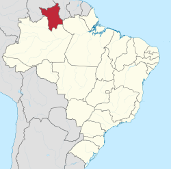
| Country | Brazil | ||
| Capital | Boa Vista | ||
| surface | 224,300.5 km² | ||
| Residents | 450,479 (2010) | ||
| density | 2 inhabitants per km² | ||
| ISO 3166-2 | BR-RR | ||
 |
|||


Coordinates: 2 ° N , 61 ° W
The list of parishes in Roraima includes all 15 parishes in the Brazilian state of Roraima that have the status of a município under Brazilian local law.
It contains the results of the 2010 census for Roraima as announced by the Instituto Brasileiro de Geografia e Estatística (IBGE). More recent estimates of the population were published by the IBGE on July 1, 2019. The next census is scheduled for 2020 every 10 years.
Communities
![]() Map with all the coordinates of the municipalities section : OSM
Map with all the coordinates of the municipalities section : OSM
The entries are primarily sorted alphabetically according to place names, they can also be sorted according to the number of inhabitants; column 1 shows the respective ranking according to the 2010 census . Further categories are: Area, after which the geostatistical classifications that have been in force since 2017, referred to as Região geográfica intermediária (indirect) and Região geográfica imediata (direct), are also listed.


photos

Center Boa Vista
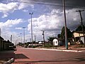
Ayrton Senna avenue in Rorainópolis


See also
Web links
- Instituto Brasileiro de Geografia e Estatística (IBGE): Cidades @ Roraima . See the location entries there.
- Governo de Roraima website (Portuguese)
- Portal RR - Governo do Estado de Roraima (Portuguese)
Individual evidence
- ↑ IBGE : Estados @: Roraima. Síntese 2010 . Retrieved August 21, 2015 (Portuguese).
- ↑ IBGE : Cidades @: Roraima. Retrieved August 21, 2015 (Portuguese).
- ↑ IBGE : Estimativas da população residente no Brasil e unidades da federação com data de referência em 1 ° de julho de 2019. (PDF) Retrieved on September 10, 2019 (Brazilian Portuguese).
Região geográfica intermediária and Região geográfica imediata
|
Boa Vista Code: 1401 |
|||||
|
Rorainópolis-Caracaraí Code: 1402 |
|
