
João Pessoa
| Município de João Pessoa João Pessoa |
|||
|---|---|---|---|
 Image montage of João Pessoa
|
|||
|
|||
| Coordinates | 7 ° 7 ′ S , 34 ° 53 ′ W | ||
 Location of the municipality in the state of Paraíba Location of the municipality in the state of Paraíba
|
|||
| Symbols | |||
|
|||
|
Motto "Intrepida ab origine (" Intrépida desde a origem ")" Undaunted from the start |
|||
| founding | August 5, 1585 | ||
| Basic data | |||
| Country | Brazil | ||
| State | Paraíba | ||
| ISO 3166-2 | BR-PB | ||
| Região intermediária | João Pessoa (since 2017) | ||
| Região imediata | João Pessoa (since 2017) | ||
| Metropolitan area | João Pessoa | ||
| height | 40 m | ||
| Waters | Atlantic , Rio Jaguaribe , Rio Sanhauá | ||
| climate | tropical, As | ||
| surface | 211.5 km² | ||
| Residents | 723,515 (2010) | ||
| density | 3,421.3 Ew. / km² | ||
| estimate | 809.015 (July 1, 2019) | ||
| Parish code | IBGE : 2507507 | ||
| Post Code | 58000-001 to 58099-999 | ||
| Time zone | UTC −3 | ||
| Website | [1] (Brazilian Portuguese) | ||
| politics | |||
| City Prefect | Luciano Cartaxo (2017-2020) | ||
| Political party | Green Party (PV) | ||
| Culture | |||
| Patron saint | Our Lady of the Snow | ||
| economy | |||
| GDP | 18,336,936 thousand R $ 23,169 R $ per person (2015) |
||
| HDI | 0.763 (2010) | ||


João Pessoa , officially Portuguese Município de João Pessoa , is the capital of the Brazilian state Paraíba . Until 1930 it was called Município de Paraíba , or Paraíba for short . It is the center of the metropolitan region of João Pessoa and has nicknames like “Jampa”, “Cidade Real de Nossa Senhora das Neves”, “Porta do Sol”, “Extremo Oriental”, “Jota Pê” and “Cidade Brasileira do Artesanato”.
geography
The city is located on the Atlantic coast and has an estimated 809,015 inhabitants as of July 1, 2019, the Pessoenses ( pessoenses ) are called and live on a community area of 211.5 km². It is the easternmost city in America and is also known as the "city where the sun rises first" because of its location. Nearby is the Ponta do Seixas , the most easterly point on the continent. Around 7 square kilometers of the city are green.
history
Before the arrival of the Europeans, the area of today's João Pessoa was already a popular settlement area for the Indians , especially the Caetés tribe who inhabited the banks of the Rio São Domingos .
The first Europeans to set foot on the area were French in search of Brazilian wood . Around 1585 they were expelled from their positions by the Portuguese, although they had allied themselves with the Indians. The city was founded at this time.
When Portugal was ruled by the Spanish king, the city was given the name "Filipéia".
From 1634 to 1654 today's João Pessoa was occupied by the Dutch and renamed "Fredriksstad". After the reconquest by the Portuguese, the city was given the name "Paraíba", which it carried until 1930.
In 1930 the Governor of Paraíba State, João Pessoa , was assassinated in Recife. The city population then decided in a vote to rename the city "João Pessoa". In the early 1930s, a small power station was built by AEG to supply energy ; it also served to supply the Atlantic port of Porto de Cabedelo
City administration
City prefect (mayor) has been Luciano Cartaxo since 2013 . He was re-elected in the local elections in Brazil in 2016 with around 60% of the vote for the 2017 to 2020 term and at the time was a member of the Partido Social Democrático (PSB), founded in 2011 , in order to become Partido Verde , the Brazilian Green Party , in March 2018 switch. The legislature lies with a 27-member city council made up of elected city councilors ( vereadores ).
religion
João Pessoa is the seat of the Paraíba Archdiocese .
One of the oldest and therefore most important churches in the city is the former Franciscan monastery of São Francisco ( Igreja da Ordem Terceira de São Francisco ) in the historical center of the city. Other Franciscan monasteries are São Pedro (also abandoned) and Nossa Senhora do Rosário in the Jaguaribe district. The latter is also a parish, which is still looked after by Franciscans today.
heritage Site
The old town with the Bairro Centro was declared a national cultural monument on December 6, 2007. It covers around 37 hectares with around 700 buildings since the city's early colonial history
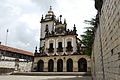
Igreja de Sao Francisco

Chapel interior with rich carvings

Detail of the sacristy ceiling


traffic
The place is on the BR-101 , one of the most important federal highways in Brazil, which follows a large part of the east coast of the country from north to south. The airport Presidente Castro Pinto International Airport ( IATA code : JPA, ICAO SBJP) is located in the neighboring municipality of Bayeux .
sons and daughters of the town
- Carlos Gouvêa Coelho (1907–1964), Roman Catholic clergyman, Archbishop of Olinda e Recife
- Eliseu Maria Gomes de Oliveira (1920–2002), Bishop of Itabuna
- Ariano Suassuna (1927-2014), writer
- Geraldo Vandré (* 1935), singer, guitarist and composer
- Hitler de Siqueira Campos Cantalice (1940-2000), judge
- Júnior (* 1954), 70-time Brazilian national soccer player
- Ariano Fernandes (* 1963), politician
- Fumaça (* 1973), Brazilian-Portuguese soccer player
- Basílio de Moraes (* 1982), Olympic track and field athlete
- Mayssa Pessoa (* 1984), handball player
- Paulo Henrique Carneiro Filho (* 1989), football player
- Vitor Gonçalves Felipe (* 1991), beach volleyball player
- Douglas Santos (* 1994), football player
- Otávio (born 1995), football player
- George Souto Maior Wanderley (* 1996), beach volleyball player
- Matheus Cunha (* 1999), soccer player
Web links
- City Prefecture Unofficial Website (Brazilian Portuguese)
- City Council website , Câmara Municipal (Brazilian Portuguese)
Individual evidence
- ↑ a b IBGE : João Pessoa - Panorama. Retrieved August 31, 2019 (Brazilian Portuguese).
- ^ German power plant in South America. In: HELIOS No. 44 of November 3, 1935.
- ^ João Pessoa - Patrimônio Nacional. Retrieved January 16, 2018 (Portuguese).