Cape Maisí: Difference between revisions
Content deleted Content added
not speediable. may be short, but is a valid geographical subject with the chance for expansion. if you want to argue that, please take it to WP:AFD. |
No edit summary |
||
| (15 intermediate revisions by 11 users not shown) | |||
| Line 1: | Line 1: | ||
{{Short description|Cape at the eastern extremity of Cuba}}{{redirect|Punta Maisí|the municipality|Maisí|the lighthouse|Punta Maisí Lighthouse}} |
|||
| ⚫ | |||
{{Infobox landform |
|||
| water = |
|||
| ⚫ | |||
| name = Cabo Maisí |
|||
| other_name = |
|||
| type = [[Cape (geography)|Cape]] |
|||
| photo = |
|||
| photo_width = |
|||
| photo_alt = |
|||
| photo_caption = |
|||
| map = Cuba |
|||
| map_width = 250px |
|||
| map_caption = Location of Cape Maisí in Cuba |
|||
| map_alt = |
|||
| relief = yes |
|||
| label = |
|||
| label_position = |
|||
| mark = |
|||
| marker_size = |
|||
| location =[[Guantanamo Province]] |
|||
| coordinates = {{Coord|20|14|38.1|N|74|8|34.7|W|type:landmark|display=inline,title}} |
|||
| coordinates_ref = |
|||
| range = |
|||
| part_of = |
|||
| water_bodies = [[Caribbean Sea]], [[Atlantic Ocean]] |
|||
| elevation_ft = <!-- or |elevation_m = --> |
|||
| elevation_ref = |
|||
| surface_elevation_ft = <!-- or |surface_elevation_m = --> |
|||
| surface_elevation_ref = |
|||
| highest_point = |
|||
| highest_elevation = |
|||
| highest_coords = |
|||
| length = |
|||
| width = |
|||
| area = <!-- {{Convert|NN|ha|acres}} --> |
|||
| depth = |
|||
| drop = |
|||
| formed_by = |
|||
| geology = <!-- or |type = --> |
|||
| age = |
|||
| topo = |
|||
}} |
|||
| ⚫ | |||
==See also== |
==See also== |
||
*[[Maisí |
* [[Punta Maisí Lighthouse]] |
||
* [[Cape San Antonio, Cuba|Cape San Antonio]] |
|||
==Notes== |
==Notes== |
||
| Line 10: | Line 51: | ||
==References== |
==References== |
||
*''Merriam-Webster's Geographical Dictionary, Third Edition''. Springfield, Massachusetts: Merriam-Webster, Incorporated, 1997. |
* ''Merriam-Webster's Geographical Dictionary, Third Edition''. Springfield, Massachusetts: [[Merriam-Webster]], Incorporated, 1997. |
||
{{DEFAULTSORT:Cape Maisi}} |
|||
[[Category:Landforms of Cuba]] |
|||
[[Category: |
[[Category:Headlands of Cuba|Maisi]] |
||
[[Category:Geography of Guantánamo Province]] |
|||
| ⚫ | |||
Latest revision as of 19:36, 19 May 2023
Cabo Maisí | |
|---|---|
| Coordinates: 20°14′38.1″N 74°8′34.7″W / 20.243917°N 74.142972°W | |
| Location | Guantanamo Province |
| Offshore water bodies | Caribbean Sea, Atlantic Ocean |
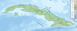
Cape Maisí or Cape Maysí is a cape at the eastern extremity of Cuba, projecting into the Windward Passage.[1] It lies in the municipality of Maisí, Guantánamo Province.
See also[edit]
Notes[edit]
- ^ Merriam-Webster's Geographical Dictionary, Third Edition, p. 691.
References[edit]
- Merriam-Webster's Geographical Dictionary, Third Edition. Springfield, Massachusetts: Merriam-Webster, Incorporated, 1997.

