
Consolação (district of São Paulo): Difference between revisions
→History: cn |
mNo edit summary |
||
| (23 intermediate revisions by 15 users not shown) | |||
Line 1:
{{short description|District of São Paulo, Brazil}}
{{redirect|Higienópolis}}
{{
{{Infobox settlement
|official_name = Consolação
Line 6 ⟶ 7:
|image_map = Consolação.png
|mapsize = 250px
|map_caption = District
|image_map1 =
|mapsize1 =
|map_caption1 =
|coordinates = {{coord|display=title,inline}}
<!-- Location -->
|subdivision_type = [[List of
|subdivision_name = [[Brazil]]
|subdivision_type1 = [[States of Brazil|State]]
Line 31 ⟶ 33:
<!-- Population -->
|population_as_of =
|population_total = 57,365
|population_density_km2 = 15,504
|blank_name = '''[[Human Development Index|HDI]]'''
|blank_info = 0.950 – <span style="color:#090">high</span>
|footnotes = <ref name="p"/>
|website = [http://
}}
==History==
Originally, the region of the city which comprises today's Consolação was inhabited by the [[Jesuits]]
==Consolação today==
===The region===
Today the district is still well known for the large upper class that lives in the area
There is currently a large number of Jewish and Jewish descendants living in the region,<ref name="SchmelzGlikson1973">{{cite book|author1=Usiel Oskar Schmelz|author2=Paul Glikson|author3=Sergio Della Pergola|title=הרצאות בדמוגרפיה של היהודים 1969: Proceedings of the Demographic Sessions Held at the 5th World Congress of Jewish Studies, Jerusalem, August 1969|url=https://books.google.com/books?id=wpMLAQAAIAAJ|year=1973|publisher=World Union of Jewish Studies}}</ref> and there are a number of synagogues and Jewish schools throughout Consolação.
==Gallery==
===Attractions and events===▼
<gallery>
The area features an array of tourist locations, local cuisine, hotels, art cinemas, many bars and nightclubs, shopping centers (Center3, Shopping Frei Caneca and Pátio Higienópolis) and the Municipal Stadium (Pacaembu Stadium) as well as being near to [[Paulista Avenue]]. Pátio Higienópolis, commonly known as Shopping Higienópolis, is located on Higienópolis Avenue, near the corner of Angélica Avenue.▼
File:Shopping Higienópolis 070912 REFON 3 PANO.JPG|Higienópolis mall
File:Higienópolis 070912 REFON 20.JPG|Streets of Higienópolis
File:Higienópolis SP building.JPG|Residential buildings
File:Entrega da nova estação Higienópolis-Mackenzie, da linha 4 (Amarela) do Metrô (24987110367).jpg|Metro Station
</gallery>
▲===Attractions and events===
▲The area features an array of tourist locations, local cuisine, hotels, art cinemas, many bars and nightclubs, shopping centers (Center3, Shopping Frei Caneca and Pátio Higienópolis) and the Municipal Stadium (Pacaembu Stadium) as well as being near to [[Paulista Avenue]]
Buenos Aires Park is a small region of the neighborhood where one can see a large variety of tropical plants and trees, if only to get away from the noise and pollution of the streets.
Line 61 ⟶ 69:
===Transportation===
The main Street of the district is called [[Consolação Street|Rua da Consolação]], which connects São Paulo's downtown to Rebouças, Paulista and Doutor Arnaldo Avenues, and has a bus corridor serving mainly North and Southbound buses across São Paulo. The district is served by
==References==
{{reflist|2|refs=
<ref name="e">{{cite web | url = http://www.encontraconsolacao.com.br/consolacao/ | title = Sobre a Consolação |
<ref name="p">{{cite web | url = http://www.prefeitura.sp.gov.br/cidade/secretarias/upload/saude/arquivos/infambiental/TxCrescimentoDensDemogrDA-SubPref_1980-2010.xls | title = População Recenseada, Taxas de Crescimento Populacional e Densidade Demográfica | year = 2011 | publisher = Prefeitura Municipal de São Paulo | format = XLS | location = São Paulo, Brazil |
}}
==External links==
* [http://se.prefeitura.sp.gov.br Subprefecture of Sé]
* [http://www.patiohigienopolis.com.br/site/ Patio Higienópolis-Home Page]
* [http://www.encontrahigienopolis.com.br/higienopolis/ Encontra Higienópolis - Find everything about Higienópolis]
| |||
Latest revision as of 13:24, 24 April 2024
This article needs additional citations for verification. (January 2017) |
Consolação | |
|---|---|
 District within the city of São Paulo | |
 | |
| Coordinates: 23°32′53″S 46°39′40″W / 23.548134°S 46.661058°W | |
| Country | Brazil |
| State | São Paulo |
| District | Consolação (district of São Paulo) |
| Government | |
| • Type | Subprefecture |
| • Subprefect | Amauri Luiz Pastorello |
| Area | |
| • Total | 3.7 km2 (1.4 sq mi) |
| Population (2007) | |
| • Total | 57,365 |
| • Density | 15,504/km2 (40,160/sq mi) |
| HDI | 0.950 – high |
| Website | Subprefecture of Sé |
| [1] | |
Consolação (Portuguese pronunciation: [kõsolaˈsɐ̃w]) is a district in the Central Zone of the city of São Paulo, Brazil. It belongs to the subprefecture of Sé. The district is largely residential, and contains many large apartment buildings and condominiums. It is also known for its prominent cultural institutions. The region has been populated since the 16th century, and is known for its buildings in the style of São Paulo Modern Architecture.[specify][2]
History[edit]
Originally, the region of the city which comprises today's Consolação was inhabited by the Jesuits and was called Sesmaria do Pacaembu. It remained thus until the beginning of the 20th century, when it was converted into a residential neighbourhood for São Paolo's upper class. It was attractive due to its high elevation, wide open streets and an array of woody plants. Also, being far from the Luz train station and out of the old city center, it was much quieter and cleaner, giving it the name Higienópolis, 'City of Hygiene', also the name of an avenue in the district.[citation needed]
Consolação today[edit]
The region[edit]
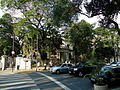
Today the district is still well known for the large upper class that lives in the area. Higienópolis contains numerous large apartment buildings, and very few, if any, houses with permanent residency.[3]
There is currently a large number of Jewish and Jewish descendants living in the region,[4] and there are a number of synagogues and Jewish schools throughout Consolação.
Gallery[edit]
-
 Higienópolis mall
 -
 Streets of Higienópolis
 -
 Residential buildings
 -
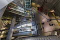 Metro Station


_do_Metr%C3%B4_(24987110367).jpg)
Attractions and events[edit]
The area features an array of tourist locations, local cuisine, hotels, art cinemas, many bars and nightclubs, shopping centers (Center3, Shopping Frei Caneca and Pátio Higienópolis) and the Municipal Stadium (Pacaembu Stadium) as well as being near to Paulista Avenue.
Buenos Aires Park is a small region of the neighborhood where one can see a large variety of tropical plants and trees, if only to get away from the noise and pollution of the streets.
Culture and education[edit]
Consolação, being in the central area of the São Paulo Metropolis, is home to numerous cultural institutions. These include Fundação Armando Alvares Penteado (FAAP), Mackenzie Presbyterian University, the São Paulo Foundation School of Sociology and Politics, Cultura Inglesa (an English language and culture school), the French Alliance, and the Central University of Maria Antonia. The Roman Catholic Colégio Sion is located on Higienópolis Avenue, right across from the Colégio Rio Branco.[2]
Transportation[edit]
The main Street of the district is called Rua da Consolação, which connects São Paulo's downtown to Rebouças, Paulista and Doutor Arnaldo Avenues, and has a bus corridor serving mainly North and Southbound buses across São Paulo. The district is served by 3 subway stations, Consolação (São Paulo Metro), Paulista (São Paulo Metro) and Higienópolis-Mackenzie (São Paulo Metro) and 1 future station: Angélica-Pacaembu (São Paulo Metro).
References[edit]
- ^ "População Recenseada, Taxas de Crescimento Populacional e Densidade Demográfica" (XLS) (in Portuguese). São Paulo, Brazil: Prefeitura Municipal de São Paulo. 2011. Retrieved 2015-02-06.
- ^ a b "Sobre a Consolação" [About Consolação] (in Portuguese). São Paulo, Brazil: Encontra São Paulo. 2015. Retrieved 2015-02-03.
- ^ Michael Sommers (28 April 2015). Moon Spotlight São Paulo: Including Iguacu Falls. Avalon Publishing. pp. 14–. ISBN 978-1-61238-938-7.
- ^ Usiel Oskar Schmelz; Paul Glikson; Sergio Della Pergola (1973). הרצאות בדמוגרפיה של היהודים 1969: Proceedings of the Demographic Sessions Held at the 5th World Congress of Jewish Studies, Jerusalem, August 1969. World Union of Jewish Studies.
External links[edit]
- Subprefecture of Sé
- Patio Higienópolis-Home Page
- Encontra Higienópolis - Find everything about Higienópolis
