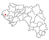
Sangarédi: Difference between revisions
Content deleted Content added
JustAMuggle (talk | contribs) Copy edit. |
No edit summary |
||
| (2 intermediate revisions by one other user not shown) | |||
| Line 83: | Line 83: | ||
|area_blank1_sq_mi = |
|area_blank1_sq_mi = |
||
<!-- Population -----------------------> |
<!-- Population -----------------------> |
||
|population_as_of = |
|population_as_of =2016 |
||
|population_footnotes = |
|population_footnotes = |
||
|population_note = |
|population_note = |
||
|population_total = |
|population_total = 81,736 |
||
|population_density_km2 = |
|population_density_km2 = |
||
|population_density_sq_mi = |
|population_density_sq_mi = |
||
| Line 122: | Line 122: | ||
}} |
}} |
||
'''Sangarédi''' is a mining town and [[sub-prefectures of Guinea|sub-prefecture]] in western [[Guinea]], where [[bauxite]] is mined. The ore is shipped by a railway to the port of [[Kamsar]]. As of |
'''Sangarédi''' is a mining town and [[sub-prefectures of Guinea|sub-prefecture]] in western [[Guinea]], where [[bauxite]] is mined. The ore is shipped by a railway to the Atlantic coast port of [[Kamsar]], 135km to the west. As of 2016, Sangarédi had a population of 81,736 people, an increase of around 5% in just two years from 2014<ref>{{cite web|url=http://www.geohive.com/cntry/guinea.aspx|title=Guinea|publisher= Institut National de la Statistique, Guinea, accessed via Geohive|accessdate=27 August 2014}}</ref> due to the expansion of the area's three bauxite mines and refinery by CBG (the Compagnie des bauxites de Guinée) which currently produces around 14,000,000 tonnes per year from Sangarédi.<ref>[http://www.cbg-guinee.com/ CBG website]</ref> |
||
In April 2010, an expansion of the mine and its refinery was proposed. |
|||
== Transport == |
== Transport == |
||
| Line 137: | Line 135: | ||
{{DEFAULTSORT:Sangaredi}} |
{{DEFAULTSORT:Sangaredi}} |
||
[[Category:Sub-prefectures of |
[[Category:Sub-prefectures of the Boké Region]] |
||
[[Category:Populated places in the Boké Region]] |
|||
{{guinea-geo-stub}} |
{{guinea-geo-stub}} |
||
Latest revision as of 17:54, 2 January 2021
Sangarédi | |
|---|---|
Sub-prefecture and town | |
| Coordinates: 11°06′N 13°46′W / 11.100°N 13.767°W | |
| Country | |
| Region | Boke Region |
| Elevation | 456 ft (139 m) |
| Population (2016) | |
| • Total | 81,736 |
Sangarédi is a mining town and sub-prefecture in western Guinea, where bauxite is mined. The ore is shipped by a railway to the Atlantic coast port of Kamsar, 135km to the west. As of 2016, Sangarédi had a population of 81,736 people, an increase of around 5% in just two years from 2014[1] due to the expansion of the area's three bauxite mines and refinery by CBG (the Compagnie des bauxites de Guinée) which currently produces around 14,000,000 tonnes per year from Sangarédi.[2]
Transport[edit]
The town is served by Sangarédi Airport.
References[edit]
- ^ "Guinea". Institut National de la Statistique, Guinea, accessed via Geohive. Retrieved 27 August 2014.
- ^ CBG website


