
Galičnik: Difference between revisions
m Sort Template:Expand language by topic |
|||
| (151 intermediate revisions by 67 users not shown) | |||
| Line 1: | Line 1: | ||
{{Expand Macedonian|topic=geo|Галичник|date=January 2022}} |
|||
[[Image:Galicka kukja.jpg|thumb|240px|Hillside building in Galičnik.]]'''Galičnik''' ([[Macedonian language|Macedonian]]: ''Галичник'') is a mountain [[village]] in the [[Republic of Macedonia]]. It is located on the [[slope]]s of the [[Bistra mountain]], in the heart of the region of the [[Mijaci tribe]], about 10 km from the artificial lake of [[Mavrovo]] and the [[winter resort]] of [[Zare Lazareski]]. It is famous for the "[[Galichnik Wedding Festival|Galička Svadba]]", a traditional and public summer wedding, held annually on the day of the village feast of the [[Patron Saint]] – [[Petrovden]] ([[St. Peter]]'s day). During the wedding, local men will dance the "Teškoto"[http://www.soros.org.mk/konkurs/076/angver/Teskoto.html] (the ''"hard"'' or ''"heavy"'') - a dance that is meant to symbolize the overcoming of difficulties in life ([http://www.soros.org.mk/konkurs/076/makver/Teskoto.wav .wav sound file]). |
|||
{{Infobox settlement |
|||
<!--See Template:Infobox Settlement for additional fields that may be available--> |
|||
<!--See the Table at Infobox Settlement for all fields and descriptions of usage--> |
|||
<!-- Basic info ----------------> |
|||
|name = Galičnik <!-- at least one of the first two fields must be filled in --> |
|||
|official_name = |
|||
|other_name = |
|||
|native_name =Галичник <!-- if different from the English name --> |
|||
|nickname = |
|||
|settlement_type =Village |
|||
|total_type = <!-- to set a non-standard label for total area and population rows --> |
|||
|motto = |
|||
<!-- images and maps -----------> |
|||
|image_skyline = Galichnik-View-Northern-Slope.jpg |
|||
|imagesize = |
|||
|image_caption = |
|||
|image_flag = |
|||
|flag_size = |
|||
|image_seal = |
|||
|seal_size = |
|||
|image_shield = |
|||
|shield_size = |
|||
|image_blank_emblem = |
|||
|blank_emblem_type = |
|||
|blank_emblem_size = |
|||
|image_map = |
|||
|mapsize = |
|||
|map_caption = |
|||
|image_map1 = |
|||
|mapsize1 = |
|||
|map_caption1 = |
|||
|image_dot_map = |
|||
|dot_mapsize = |
|||
|dot_map_caption = |
|||
|dot_x = |dot_y = |
|||
|pushpin_map = North Macedonia |
|||
|pushpin_label_position = <!-- the position of the pushpin label: left, right, top, bottom, none --> |
|||
|pushpin_map_caption = Location within North Macedonia |
|||
|pushpin_mapsize = |
|||
<!-- Location ------------------> |
|||
|subdivision_type = [[List of sovereign states|Country]] |
|||
|subdivision_name = {{NMK}} |
|||
|subdivision_type1 = [[Statistical Regions of North Macedonia|Region]] |
|||
|subdivision_name1 = [[File:Logo of Polog Region.svg|13px]] [[Polog Statistical Region|Polog]] |
|||
|subdivision_type2 = [[Municipalities of North Macedonia|Municipality]] |
|||
|subdivision_name2 = [[File:Coat of arms of Mavrovo and Rostuša Municipality.svg|15px]] [[Mavrovo and Rostuša Municipality|Mavrovo and Rostuša]] |
|||
<!-- Smaller parts (e.g. boroughs of a city) and seat of government --> |
|||
|seat_type = |
|||
|seat = |
|||
|parts_type = |
|||
|parts_style = <!-- =list (for list), coll (for collapsed list), para (for paragraph format) |
|||
Default is list if up to 5 items, coll if more than 5--> |
|||
|parts = <!-- parts text, or header for parts list --> |
|||
|p1 = |
|||
|p2 = <!-- etc. up to p50: for separate parts to be listed--> |
|||
<!-- Politics -----------------> |
|||
|government_footnotes = |
|||
|government_type = |
|||
|leader_title = |
|||
|leader_name = |
|||
|leader_title1 = <!-- for places with, say, both a mayor and a city manager --> |
|||
|leader_name1 = |
|||
|established_title = <!-- Settled --> |
|||
|established_date = |
|||
<!-- Area ---------------------> |
|||
|area_magnitude = |
|||
|unit_pref = <!--Enter: Imperial, to display imperial before metric--> |
|||
|area_footnotes = |
|||
|area_total_km2 = <!-- ALL fields with measurements are subject to automatic unit conversion--> |
|||
|area_land_km2 = <!--See table @ Template:Infobox Settlement for details on unit conversion--> |
|||
|area_water_km2 = |
|||
|area_total_sq_mi = |
|||
|area_land_sq_mi = |
|||
|area_water_sq_mi = |
|||
|area_water_percent = |
|||
<!-- Elevation --------------------------> |
|||
|elevation_footnotes = <!--for references: use <ref> tags--> |
|||
|elevation_m = |
|||
|elevation_ft = |
|||
|elevation_max_m = 1500 |
|||
|elevation_max_ft = |
|||
|elevation_min_ft = |
|||
<!-- Population -----------------------> |
|||
|population_as_of =2021 |
|||
|population_footnotes = |
|||
|population_note = |
|||
|population_total =48 |
|||
|population_density_km2 = <!--For automatic calculation, any density field may contain: auto --> |
|||
|population_density_sq_mi = |
|||
<!-- General information ---------------> |
|||
|timezone = [[Central European Time|CET]] |
|||
|utc_offset = +1 |
|||
|timezone_DST = [[Central European Summer Time|CEST]] |
|||
|utc_offset_DST = +2 |
|||
|coor_type = <!-- can be used to specify what the coordinates refer to --> |
|||
|coordinates = {{coord|41|35|39|N|20|39|11|E|region:MK|display=inline,title}} |
|||
<!-- Area/postal codes & others --------> |
|||
|postal_code_type = Postal code |
|||
|postal_code = |
|||
|area_code = |
|||
|website = |
|||
|blank_name =[[Vehicle registration plates of North Macedonia|Car plates]] |
|||
|blank_info =GV |
|||
|blank1_name = |
|||
|blank1_info = |
|||
|footnotes = |
|||
}} |
|||
'''Galičnik''' ({{lang-mk|Галичник}}) is a mountain [[village]] in [[North Macedonia]] and along with [[Lazaropole]] is one of the two biggest and oldest [[Mijaks|Mijak]] villages in the region. Galičnik has well-preserved traditional [[architecture]], including an amphitheater in the village square, and is famous for its surrounding countryside and nature reserve. |
|||
In the past, the economy of Galičnik relied on the [[sheep]] [[trade]], while many families sent the men on a "pečalba" - abroad to work and bring home some fortune. Today, Galičnik is but only a destination of [[tourism]] and [[leisure]] for the long departed locals, many of whom return to renovate and restore old family houses and use them as a holiday refuge away from the summer heat in the capital [[Skopje]]. |
|||
==History== |
|||
People from Galičnik and northwestern Macedonia appreciate its mature yellow cheese "[[kaškaval]]" as well as the local salt brine white cheese "belo [[sirenje]]". Galičnik is also famous for its local traditional [[architecture]], including an amphitheatre in the village square, its [[summer Galičnik Art Colony]] and its countryside and nature reserve. |
|||
The village is located in the ethnographic region of "[[Mijačija]]", named after the [[Mijaks]] (Мијаци/Mijaci), the tribe historically inhabiting this mountainous region. This region has plentiful rich pastures for livestock grazing and this feature attracted [[Vlachs]], shepherds, who established settlements based on cattle-breeding and shepherding.<ref name="Welters1999">{{cite book|author=Linda Welters|title=Folk Dress in Europe and Anatolia: Beliefs about Protection and Fertility|url=https://books.google.com/books?id=35oIbNIIn-8C&pg=PA100|date=1 November 1999|publisher=Bloomsbury Academic|isbn=978-1-85973-287-8|pages=100–}}</ref> |
|||
==Events== |
|||
The most important event in the village is the [[Galichnik Wedding Festival|Galička Svadba]], a traditional wedding custom held annually in summer (in July), on the day of the village feast of the [[Patron Saint]] – ''Petrovden'' ([[St. Peter]]'s day). During the wedding, local men will dance the "Teškoto" (the ''"hard"'' or ''"heavy"'') - a dance that is meant to symbolize the overcoming of difficulties in life.<ref>{{cite web |
|||
|url=http://www.soros.org.mk/konkurs/076/angver/Teskoto.html |
|||
|title=Teskoto |
|||
|publisher=www.soros.org.mk |
|||
|accessdate=2008-10-19 |
|||
|last= |
|||
|first= |
|||
|archive-url=https://web.archive.org/web/20080724210155/http://www.soros.org.mk/konkurs/076/angver/Teskoto.html |
|||
|archive-date=2008-07-24 |
|||
|url-status=dead |
|||
}}</ref> |
|||
== Culture == |
|||
The regional art, dress and music are rich in detail and original in character. While sharing characteristics of regional culture dating back centuries. |
|||
The traditional dress and costume adorned during ceremonial events is highly detailed and unique. Examples can be seen at museums.<ref>{{cite web |
|||
|url=http://britishmuseum.org/collection/term/x58364 |
|||
|title=Galičnik Items |
|||
|publisher=British Museum}}</ref> |
|||
The village is built based on traditional housing standards used for centuries in the region. Stone wall construction, supported by wooden beams, compact earth insulation and using stone slate roofing.<ref> |
|||
{{cite book |
|||
|last=Slavko Brezoski |
|||
|first= |
|||
|author-link=www.slavkobrezoski.com |
|||
|date=1993 |
|||
|title=Rekanska Kuќa, Arhitektonsko Nasledstvo vo Makedonija |
|||
|url= |
|||
|location=University of Skopje, Architecture |
|||
|publisher=Bigoss |
|||
|page= |
|||
|isbn= |
|||
}}</ref> |
|||
[[File:Galicnik 1908.jpg|Galicnik 1908|300px]] |
|||
==Notable people from Galičnik== |
==Notable people from Galičnik== |
||
* [[Slavko Brezoski]] (1921-2017) |
|||
* [[Georgi Pulevski|George Pulevski]] (1838 - 1895) - Macedonian Revolutionary |
|||
* [[ |
* [[Lazar Ličenoski]] (1901-1964) |
||
* [[ |
* [[Doksim Mihailović]] (1883–1912) |
||
* [[ |
* [[Risto Ognjanovikj-Lonoski]] (1870-1941) |
||
* [[Georgi Pulevski]] (1817–1895) |
|||
* [[Aleksandar Sarievski]] (1922–2002) |
|||
* [[Partenij Zografski]] (1818–1876) |
|||
<gallery widths="200px" heights="200px"> |
|||
Image:20090714_Galicnik_Debar_panoramic.jpg | Galičnik, Skudrinje and Debar lake. |
|||
Image:Galichnik-St-Peter&Paul-Church.jpg|Church of St. Peter and Paul. |
|||
Image:Galichnik-cheshma.jpg | Old postcard from Galičnik - 1903-1908. |
|||
Image:Galičnik_04.jpg | Architecture in Galičnik. |
|||
File:Molba za dozvola za kupuvanje, Galicnik, 1917.JPG|Request with a stamp from Kipro Mitrev, from village Sushica, Galichnik area, asking to get permission to buy sheep. (18 March 1917) |
|||
File:Broj na ziteli po narodnost, Galicnik, 1917.JPG|Population by nationality in ten municipalities of the city's municipal government of the City Galichnik 1917. |
|||
</gallery> |
|||
==References== |
|||
{{Reflist}} |
|||
==External links== |
==External links== |
||
*[https://archive.today/20130111215112/http://www.galichnik-official.mk/ Official web site of Galichnik] |
|||
*[http://www.galicnik.com/index_en.htm Website of Galičnik] |
|||
*[https://web.archive.org/web/20050323025455/http://www.culture.in.mk/story.asp?id=3446 Penultimate Phase of Procedure for Entrance of Galicnik Wedding in UNESCO List - Custom with More than 30 Rites] |
|||
*[http://www.fallingrain.com/world/MK/0/Galicnik.html Location of Galichnik] |
|||
*[https://www.youtube.com/watch?v=ThslSSNLGEo Galicnik Macedonia, Kinoteka na Makedonija 1939-40 from filmarchivesonline] |
|||
*[http://www.culture.in.mk/story.asp?id=3446 Penultimate Phase of Procedure for Entrance of Galicnik Wedding in UNSECO List - Custom with More than 30 Rites] |
|||
*[https://web.archive.org/web/20110722215421/http://www.galichnik-official.mk/GalichnikJ/index.php?option=com_morfeoshow&task=view&gallery=8&Itemid=56&lang=en Images from Galičnik] |
|||
*[http://www.culture.org.mk/egalicnik-image%20gallery.htm Images from Galičnik] |
|||
*[http://www.balkanfolk.com/gallery.php?id=77&picid=621 Photos from Galichnik Wedding] |
|||
*[http://faq.macedonia.org/travel/mountains/mavrovo.html Mavrovo National Park] |
|||
* [http://strumski.com/biblioteka/?id=1807 "Narodne pesme bugarske (iz Galečnika)"], folk songs from Galichnik, published in the Croatian magazine "Kolo; Članci za Literaturu, Umetnost; Narodni Život", knjiga IV/V, Zagreb, in 1847. |
|||
{{Commons category|Galičnik}} |
|||
== References == |
|||
<div class="references-small"><references /></div> |
|||
{{Mavrovo and Rostuša Municipality}} |
|||
[[Category:Villages in the Republic of Macedonia]] |
|||
{{Authority control}} |
|||
{{DEFAULTSORT:Galicnik}} |
|||
[[bg:Галичник]] |
|||
[[Category:Villages in Mavrovo and Rostuša Municipality]] |
|||
[[mk:Галичник]] |
|||
[[sr:Галичник]] |
|||
Latest revision as of 00:19, 1 June 2024
You can help expand this article with text translated from the corresponding article in Macedonian. (January 2022) Click [show] for important translation instructions.
|
Galičnik
Галичник | |
|---|---|
Village | |
 | |
 Galičnik Location within North Macedonia | |
| Coordinates: 41°35′39″N 20°39′11″E / 41.59417°N 20.65306°E | |
| Country | |
| Region | |
| Municipality | |
| Highest elevation | 1,500 m (4,900 ft) |
| Population (2021) | |
| • Total | 48 |
| Time zone | UTC+1 (CET) |
| • Summer (DST) | UTC+2 (CEST) |
| Car plates | GV |
Galičnik (Macedonian: Галичник) is a mountain village in North Macedonia and along with Lazaropole is one of the two biggest and oldest Mijak villages in the region. Galičnik has well-preserved traditional architecture, including an amphitheater in the village square, and is famous for its surrounding countryside and nature reserve.
History[edit]
The village is located in the ethnographic region of "Mijačija", named after the Mijaks (Мијаци/Mijaci), the tribe historically inhabiting this mountainous region. This region has plentiful rich pastures for livestock grazing and this feature attracted Vlachs, shepherds, who established settlements based on cattle-breeding and shepherding.[1]
Events[edit]
The most important event in the village is the Galička Svadba, a traditional wedding custom held annually in summer (in July), on the day of the village feast of the Patron Saint – Petrovden (St. Peter's day). During the wedding, local men will dance the "Teškoto" (the "hard" or "heavy") - a dance that is meant to symbolize the overcoming of difficulties in life.[2]
Culture[edit]
The regional art, dress and music are rich in detail and original in character. While sharing characteristics of regional culture dating back centuries.
The traditional dress and costume adorned during ceremonial events is highly detailed and unique. Examples can be seen at museums.[3]
The village is built based on traditional housing standards used for centuries in the region. Stone wall construction, supported by wooden beams, compact earth insulation and using stone slate roofing.[4]

Notable people from Galičnik[edit]
- Slavko Brezoski (1921-2017)
- Lazar Ličenoski (1901-1964)
- Doksim Mihailović (1883–1912)
- Risto Ognjanovikj-Lonoski (1870-1941)
- Georgi Pulevski (1817–1895)
- Aleksandar Sarievski (1922–2002)
- Partenij Zografski (1818–1876)
-
 Galičnik, Skudrinje and Debar lake.
 -
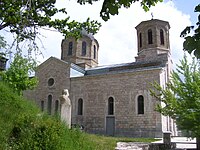 Church of St. Peter and Paul.
 -
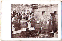 Old postcard from Galičnik - 1903-1908.
 -
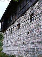 Architecture in Galičnik.
 -
 Request with a stamp from Kipro Mitrev, from village Sushica, Galichnik area, asking to get permission to buy sheep. (18 March 1917)
 -
 Population by nationality in ten municipalities of the city's municipal government of the City Galichnik 1917.


References[edit]
- ^ Linda Welters (1 November 1999). Folk Dress in Europe and Anatolia: Beliefs about Protection and Fertility. Bloomsbury Academic. pp. 100–. ISBN 978-1-85973-287-8.
- ^ "Teskoto". www.soros.org.mk. Archived from the original on 2008-07-24. Retrieved 2008-10-19.
- ^ "Galičnik Items". British Museum.
- ^ Slavko Brezoski (1993). Rekanska Kuќa, Arhitektonsko Nasledstvo vo Makedonija. University of Skopje, Architecture: Bigoss.
External links[edit]
- Official web site of Galichnik
- Penultimate Phase of Procedure for Entrance of Galicnik Wedding in UNESCO List - Custom with More than 30 Rites
- Galicnik Macedonia, Kinoteka na Makedonija 1939-40 from filmarchivesonline
- Images from Galičnik
- Photos from Galichnik Wedding
- "Narodne pesme bugarske (iz Galečnika)", folk songs from Galichnik, published in the Croatian magazine "Kolo; Članci za Literaturu, Umetnost; Narodni Život", knjiga IV/V, Zagreb, in 1847.
| International | |
|---|---|
| National | |