Sagnarigu Municipal District: Difference between revisions
m Added an interlink Tags: Visual edit Mobile edit Mobile web edit Advanced mobile edit |
m Added an interlink Tags: Visual edit Mobile edit Mobile web edit Advanced mobile edit |
||
| Line 59: | Line 59: | ||
[[Gurugu]] |
[[Gurugu]] |
||
Katariga |
[[Katariga]] |
||
Malishegu |
Malishegu |
||
Revision as of 08:00, 14 December 2021
Sagnarigu Municipal District | |
|---|---|
Municipal District | |
 Districts of Northern Region | |
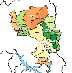
Location of Sagnarigu Municipal District within Northern | |
| Coordinates: 9°25′21.72″N 0°53′26.88″W / 9.4227000°N 0.8908000°W | |
| Country | |
| Region | Northern |
| Capital | Sagnarigu |
| Population (2021) | |
| • Total | 341,711[1] |
| Time zone | UTC+0 (GMT) |
| ISO 3166 code | GH-NP-SG |
Sagnarigu Municipal District is one of the sixteen districts in Northern Region, Ghana.[2][3][4][5] Originally it was formerly part of the then-larger Tamale Municipal District in 1988, which was created from the former West Dagomba District Council, until a small northern part of the district was split off to create Sagnarigu District on 24 June 2012; thus the remaining part has been retained as Tamale Metropolitan District (which it was elevated to metropolitan district assembly status on August 2004). However on 15 March 2018, it was elevated to municipal district assembly status to become Sagnarigu Municipal District. The municipality is located in the northwest part of Northern Region and has Sagnarigu as its capital city (which is also the capital city of the Northern Region).
Communities
The communities includes:
Sagnarigu main
sanarigu Kukuo
Malishegu
References
- ^ Ghana: Administrative Division
- ^ Edmond Gyebi (2 October 2013). "Sagnarigu Cries For Municipal Status". Thechronicle. Tamale. Retrieved April 10, 2015.
- ^ Naatogmah, Abdul Karim (2 March 2015). "Sagnarigu Assembly builds complex". citifmonline. Tamale. Retrieved April 10, 2015.
- ^ Samuel Duodu (23 March 2015). "Calm returns to Malshegu and Gumo in the Sagnarigu and Kumbungu districts". Graphic.com. Sagnarigu. Retrieved April 10, 2015.
- ^ "Northern » Sagnarigu (New)". Ghanadistricts. Archived from the original on October 16, 2012. Retrieved April 10, 2015.

