Bottelare: Difference between revisions
Content deleted Content added
DagneyGirl (talk | contribs) spelling |
KittenKlub (talk | contribs) infobox |
||
| Line 1: | Line 1: | ||
{{Infobox settlement |
|||
| name = Bottelare |
|||
| other_name = |
|||
| settlement_type = Village |
|||
| image_skyline = File:Kasteel van Bottelare.jpg |
|||
| imagesize = |
|||
| image_alt = |
|||
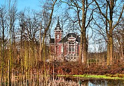
| image_caption = Castle of Bottelare |
|||
| image_shield = |
|||
| image_flag = |
|||
| pushpin_map = Belgium |
|||
| pushpin_label_position = left |
|||
| pushpin_map_caption = Location in Belgium |
|||
| pushpin_mapsize = 250 |
|||
| mapsize = |
|||
| map_alt = |
|||
| map_caption = |
|||
| subdivision_type = Country |
|||
| subdivision_name = [[Belgium]] |
|||
| subdivision_type1 = [[Provinces of Belgium|Province]] |
|||
| subdivision_name1 = [[East Flanders]] |
|||
| subdivision_type2 = [[Municipalities of Belgium|Municipality]] |
|||
| subdivision_name2 = [[Merelbeke]] |
|||
| elevation_m = |
|||
| area_footnotes = <ref name="stat"/> |
|||
| area_total_km2 = 3.01 |
|||
| population_footnotes = <ref name="stat">{{cite web|url=https://statbel.fgov.be/sites/default/files/files/opendata/bevolking/sectoren/OPENDATA_SECTOREN_2021.xlsx |title=Bevolking per statistische sector - Sector 44043B |website=Statistics Belgium |access-date=7 May 2022 }}</ref> |
|||
| population_as_of = 2021 |
|||
| population_total = 1,860 |
|||
| population_density_km2 = auto |
|||
| postal_code_type = [[Postal code]] |
|||
| postal_code = |
|||
| area_code_type = [[Telephone numbering plan|Area code]] |
|||
| area_code = |
|||
| timezone = [[Central European Time|CET]] |
|||
| utc_offset = |
|||
| website = |
|||
| footnotes = |
|||
| ⚫ | |||
}} |
|||
'''Bottelare''' is a village in the province of [[East Flanders]], [[Belgium]], at the edge of the [[Flemish Ardennes]]. It is now part of the municipality of [[Merelbeke]]. |
'''Bottelare''' is a village in the province of [[East Flanders]], [[Belgium]], at the edge of the [[Flemish Ardennes]]. It is now part of the municipality of [[Merelbeke]]. |
||
| Line 14: | Line 54: | ||
== External links == |
== External links == |
||
* [https://web.archive.org/web/20120926042654/http://www.reocities.com/belgiumtowns/bottelarekerk.html Webpage at Reocities] |
* [https://web.archive.org/web/20120926042654/http://www.reocities.com/belgiumtowns/bottelarekerk.html Webpage at Reocities] |
||
| ⚫ | |||
[[Category:Populated places in East Flanders]] |
[[Category:Populated places in East Flanders]] |
||
Revision as of 06:53, 8 May 2022
Bottelare | |
|---|---|
Village | |
 Castle of Bottelare | |
| Coordinates: 50°58′N 3°45′E / 50.967°N 3.750°E | |
| Country | Belgium |
| Province | East Flanders |
| Municipality | Merelbeke |
| Area | |
| • Total | 3.01 km2 (1.16 sq mi) |
| Population (2021)[1] | |
| • Total | 1,860 |
| • Density | 620/km2 (1,600/sq mi) |
| Time zone | CET |
Bottelare is a village in the province of East Flanders, Belgium, at the edge of the Flemish Ardennes. It is now part of the municipality of Merelbeke.
During the 17th century, Bottelare became a famous pilgrimage place, dedicated to Saint Anne.[2] Its gorgeous hall church, a large statue of Saint Anne and the Saint Anne Chapel in the village centre are witnesses of this.
Places of interest
-
Church of Bottelare (2007)
-
Saint Anne Chapel of Bottelare (2007)
References
- ^ a b "Bevolking per statistische sector - Sector 44043B". Statistics Belgium. Retrieved 7 May 2022.
- ^ Koenraad DE WOLF, Architectuurgids Zuid-Oost-Vlaanderen. Barok, Rococo & Classicisme (1625-1800), 1998, pp. 76-78 and p. 127.


