Chylonia: Difference between revisions
Content deleted Content added
Marcin 303 (talk | contribs) No edit summary |
Added tags to the page using Page Curation (stub) |
||
| Line 38: | Line 38: | ||
[[Category:Districts of Gdynia]] |
[[Category:Districts of Gdynia]] |
||
{{stub}} |
|||
Revision as of 20:03, 25 February 2023
Chylonia | |
|---|---|
District of Gdynia | |
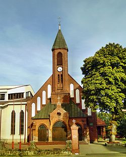
 Saint Nicholas church | |
 Location of Chylonia within Gdynia | |
| Coordinates: 54°32′32″N 18°27′56″E / 54.54222°N 18.46556°E | |
| Country | |
| Voivodeship | Pomeranian |
| County/City | Gdynia |
| Within city limits | 1930 |
| Area | |
| • Total | 3.84 km2 (1.48 sq mi) |
| Population (2022[1]) | |
| • Total | 20,450 |
| • Density | 5,300/km2 (14,000/sq mi) |
| Time zone | UTC+1 (CET) |
| • Summer (DST) | UTC+2 (CEST) |
| Vehicle registration | GA |
Chylonia is a district of Gdynia, Poland,[2] located in the northern part of the city.
Chylonia was a royal village of the Kingdom of Poland, administratively located in the Puck County in the Pomeranian Voivodeship.[3]
Transport
The Gdynia Chylonia and Gdynia Leszczynki railway stations are located in Chylonia.
References
- ^ a b "Dzielnice". BIP UM Gdynia (in Polish). Retrieved 25 February 2023.
- ^ Rozporządzenie Ministra Administracji i Cyfryzacji z dnia 13 grudnia 2012 r. w sprawie wykazu urzędowych nazw miejscowości i ich części, Dz. U. z 2013 r. poz. 200
- ^ Biskup, Marian; Tomczak, Andrzej (1955). Mapy województwa pomorskiego w drugiej połowie XVI w. (in Polish). Toruń. p. 100.
{{cite book}}: CS1 maint: location missing publisher (link)

