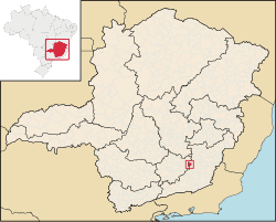
Brás Pires: Difference between revisions
Content deleted Content added
m robot Adding: nl:Brás Pires |
Luckas-bot (talk | contribs) m r2.7.1) (robot Adding: es:Brás Pires |
||
| Line 13: | Line 13: | ||
[[Category:Populated places in Minas Gerais|Brás Pires]] |
[[Category:Populated places in Minas Gerais|Brás Pires]] |
||
[[es:Brás Pires]] |
|||
[[eo:Brás Pires]] |
[[eo:Brás Pires]] |
||
[[bpy:ব্রাস পিরেস]] |
[[bpy:ব্রাস পিরেস]] |
||
Revision as of 14:08, 30 January 2011

Brás Pires is a Brazilian municipality located in the state of Minas Gerais. The city belongs to the mesoregion of Zona da Mata and to the microregion of Viçosa.
